Latrigg and Lonscale Fell (Lake District)
At the beginning of November we made our final trip of the year to the Lake District. Before winter set in and all our Christmas preparations began we had decided to spend a couple of nights in Keswick, regardless of what the weather may have in store for us. The plan was primarily to enjoy the shops and pubs and then, if we did manage to fit in a climb or a walk, that would be a bonus. It was something of a last-minute decision, but even so I was a little surprised to find that accommodation in Keswick was hard to come by so late in the year. After an hour or so of internet searching I was finally able to book a couple of nights in a guesthouse on the edge of town, overlooking the River Greta. I must admit it wouldn't have been my first choice, but it actually turned out to be pleasant, convenient and very reasonably priced.
We left home early on a blustery and wet Friday morning, with the intention of arriving in Keswick by late morning and having lunch and a walk around the shops before checking in to our accommodation. Thirty miles into our journey, however, I was suddenly struck by the disturbing thought that I may have left one of our bags at home. I pulled the car over into the next lay-by and hesitantly opened the boot, a string of expletives confirming to anyone within earshot that my hunch had been correct. The bag containing our toiletries, phone chargers and maps was nowhere to be seen. I could picture it clearly in my mind now. I'd left it on the bedroom floor. We sat for a few minutes doing a spot of mental arithmetic and it quickly became obvious that, even assuming we could purchase the correct phone chargers, the cost of purchasing all of the forgotten items in Keswick would be far greater than the cost of the petrol consumed in returning home. There then followed a tedious journey home again in the thickest of the school run traffic. Two hours after first setting off, and at about the time we should have been travelling westwards along the A66, we were home again, drinking coffee.
Thankfully, our second attempt at the journey was uneventful and we eventually arrived in Keswick in time for a very late lunch, my frustration at my silly oversight quickly soothed away by a welcome glass of Snecklifter. Over dinner that evening we selected our route for the following day, deciding to walk directly from the guesthouse for a climb of Latrigg, Lonscale Fell and, time permitting, another ascent of Skiddaw.
The morning was overcast and a little breezy, but not too cold, as we set off along the banks of the Greta, heading for Spooneygreen Lane and the start of our first ascent of the day. After a short distance I turned back to look in the direction of our guesthouse which looked very pretty behind a foreground of the river and autumn foliage and set against a backdrop of cloud-topped mountains.
Walking a little further along the lane gave us a clear view of Latrigg, our first climb of the day. Standing at 1,207 feet (368m), Latrigg is one of the lowest of the Lakeland Fells and perhaps the most accessible of all the Wainwrights. Although we were going to walk from Keswick, many people prefer to drive to the car park which isn't very far from the top of Latrigg and from where there are wheelchair accessible paths all the way to the summit. The most surprising fact, for me, about Latrigg is that in all the times I have visited Keswick, this was to be the first time I had ventured up there.

As we climbed along Spooneygreen Lane and skirted around the base of Latrigg, the sun periodically broke through the clouds, illuminating the slopes of Skiddaw and highlighting the thickness of the cloud cover on top. The landscape was cloaked in autumn tones and we stopped for a while, just to drink in the beauty of our surroundings. Skiddaw is a mountain I am always happy to look upon, whatever the time of year.

One of the beauties of Latrigg is that it offers the visitor a wonderful view over Keswick, Derwentwater and the mountains beyond. Although we were denied a clear view of most of the mountains, it was a delight to see Keswick, bathed in a patch of sunlight which was doing its best to break through the thick, glowering clouds. Even at this height it was a lot colder than it had been on the lower ground and so we didn't hang around for long, resolving to return to this point in the summer with the hope of a clearer view.

From the summit of Latrigg we struck off in an easterly direction, heading towards the lower slopes of Lonscale Fell. Our route took us through a field of sheep, clearly so used to human traffic that they didn't even look up from their grazing as we passed. In the background the top of Blencathra was just visible beneath a wispy band of cloud.

Before we could begin our next ascent it was necessary to descend from Latrigg, passing through the car park to where the main tourist path to Skiddaw begins, and then turning onto the route of the Cumbrian Way. This path took us down to a crossing of Whit Beck which was flowing swiftly along the col between the lower slopes of Skiddaw Little Man and Lonscale Fell.

Studying my copy of Wainwright had presented us with several options for a climb of Lonscale Fell. Perhaps the most straightforward route would have been to follow the Skiddaw tourist path as far as Jenkin Hill before taking a right turn, at which point most of the hard work would have been done, leaving us with an easy final ascent. There were also, apparently, a couple of indistinct paths through the bracken after crossing Whit Beck, but as I looked over in that direction all I could see was a sea of autumn-bronzed bracken and a cyclist slowly ascending along the route of the Cumbrian Way. Our fourth option was to follow the same route as the cyclist until the path turned the corner above the Glenderaterra Beck from where we could begin a steep ascent up the side of Lonscale Crags. I took my OS map out of my rucksack and studied the contours for this climb. It was going to be a steep one, but I felt up for the challenge, particularly as I had recently shed just over a stone and a half in weight.

We left the route of the Cumbrian Way after passing through a gate, and immediately our climb began, following the course of a fence in a steep ascent above the rocky face of Lonscale Crags. We had not ascended far before the cloud cover enveloped us, robbing us of a view over the edge of the Crags and concealing the summit from our sight. It was a strenuous climb and the density of the murky clouds meant that as we climbed we had no way of telling how far we may be from the summit.

Along the way we passed the rotting carcass of a sheep at which point I discovered that it was rather hard to climb and hold your breath at the same time. The need to escape the stench propelled me uphill a little faster until I could go no further and had to stop to gasp in a lungful of uncontaminated air. As I did so a sudden gust of wind lifted the cloud around me and I turned to look down upon Blease Fell and the land below Blencathra lit by sunlight, with the fells above Threlkeld disappearing in the cloud.

Once the cloud had descended in earnest the visibility was very poor all the way to the summit, where the wind was gusting strongly bringing with it sheets of icy rain. It wasn't a place to hang around and I paused, almost rigid with cold, for a quick snapshot by the summit above East Peak before we hurried on to find our ridge route across to Little Man.

According to my copy of the Lakeland Fellranger Guide for Lonscale Fell, a hurdle gate in a corner of the fence we had followed to the summit should have led us onto a path towards Jenkin Hill and then onwards to Little Man and the summit of Skiddaw. In the thick cloud cover, however, no such gate was visible and I stopped frequently to consult my map and GPS. Suddenly the path we were following descended very steeply ahead of us and I was now certain that we were heading the wrong way. We were walking in a northerly direction, whilst the summit of Little Man was to the west, and yet all the while a fence barred our way. At this point the cloud cover was so dense that all we could see was the fence to our left and a few feet ahead. The path was very steep and slippery and more than once I lost my footing, sitting down heavily to prevent a downhill roll. It was whilst I was thus seated, recovering from a heavy landing, that the clouds suddenly parted, almost as if accompanied by someone singing "Ta-daaa", at which point a spectacular and very welcome sight was revealed. I remained seated for a little while, reaching for my camera before the cloud descended once more. What I could see was a splendid view of the waters of Roughton Gill cascading down the side of Blease Fell from Blencathra to meet the Glenderaterra Beck. This confirmed that we were now sitting on a crest known as Burnt Horse, this name being a corruption of "Burnt Hause" or "heather-burn pass". From here, I realised, we could descend to meet up with the Cumbrian Way again, just below Skiddaw House.

It wasn't long before our path levelled out to a more comfortable descent. As we left the cloud cover of the higher ground we caught our first glimpse of the Youth Hostel at Skiddaw House, surrounded by sheltering trees.

Now we were back on the Cumbrian Way again, having re-joined it to the north of Lonscale Fell. From here we were presented with something of a dilemma. I really wanted to visit the summit of Skiddaw again but, as far as I knew, the best route from this point would be to follow the Cumbrian Way northwards as far as Whitewater Dash and then ascend Birkett Edge to Bakestall and on to the top of Skiddaw, descending via the tourist route back to Keswick. It was approaching 3 p.m. and British Summertime had ended a week ago, meaning we would lose light at around 5 p.m. As neither of us had torches with us, the only sensible thing to do was to return to Keswick by following the Cumbrian Way back to where we had started.
As an illustration, I have included below a photo taken in July 2014, approaching from the north and showing the peak of Lonscale Fell with the crest of Burnt Horse just above Skiddaw House. On this image I have marked the route by which we had just descended.

Our route now followed the rocky path which curves its way around the foot of Lonscale Fell, above the Glenderaterra Beck. Ahead of us the clouds were obscuring a view down the valley of St John's in the Vale, but even so it was a beautiful sight and a joy to be walking along this, one of my favourite paths in Lakeland.

As Tom walked on ahead of me I took a photograph to compare with one I had taken the last time we followed this route, in July 2014 (on my birthday!). It was nice to contrast the seasonal differences of this wonderful view.

Before we walked around the corner of Lonscale Fell to head back towards Latrigg, I turned to take one last photo of the Glenderaterra Beck rushing along below.

A flock of sheep had gathered at the foot of Latrigg as the daylight began to fade. I was struck by the red dye marking their fleeces which almost made them look pink in the late afternoon light. I had recently read that sheep in Lakeland are sometimes given red markings, not to denote ownership but as part of a local practice known as "rudding", an ancient superstition with no known practical purpose (reference Counting Sheep by Phillip Walling).

Our walk concluded with a further ascent of Latrigg before we descended along Spooneygreen Lane, calling in for a very welcome pint at the Pheasant Inn before our return to Keswick.
I was pleased to have been able to tick another two Wainwrights off my list, but still a bit disappointed not to have managed another ascent of Skiddaw, and also a little sad to think that it would be a few months before we'd be able to visit Keswick again. As we returned to our guesthouse later that evening I could see the pinpoints of light emitted from the head torches of those brave enough to climb Skiddaw in the dark. Before we set off home the next day I paid a visit to George Fisher's where I bought myself a Petzl head torch, determined to try a little night walking during the coming winter months and then perhaps next year I too would be able to climb Skiddaw in the dark. Watch this space!

Coming soon...After a busy festive season, with time for just a few short local walks, we undertake our first proper walk of 2015 with a ten mile circuit following the Pocklington Canal in East Yorkshire.
We left home early on a blustery and wet Friday morning, with the intention of arriving in Keswick by late morning and having lunch and a walk around the shops before checking in to our accommodation. Thirty miles into our journey, however, I was suddenly struck by the disturbing thought that I may have left one of our bags at home. I pulled the car over into the next lay-by and hesitantly opened the boot, a string of expletives confirming to anyone within earshot that my hunch had been correct. The bag containing our toiletries, phone chargers and maps was nowhere to be seen. I could picture it clearly in my mind now. I'd left it on the bedroom floor. We sat for a few minutes doing a spot of mental arithmetic and it quickly became obvious that, even assuming we could purchase the correct phone chargers, the cost of purchasing all of the forgotten items in Keswick would be far greater than the cost of the petrol consumed in returning home. There then followed a tedious journey home again in the thickest of the school run traffic. Two hours after first setting off, and at about the time we should have been travelling westwards along the A66, we were home again, drinking coffee.
Thankfully, our second attempt at the journey was uneventful and we eventually arrived in Keswick in time for a very late lunch, my frustration at my silly oversight quickly soothed away by a welcome glass of Snecklifter. Over dinner that evening we selected our route for the following day, deciding to walk directly from the guesthouse for a climb of Latrigg, Lonscale Fell and, time permitting, another ascent of Skiddaw.
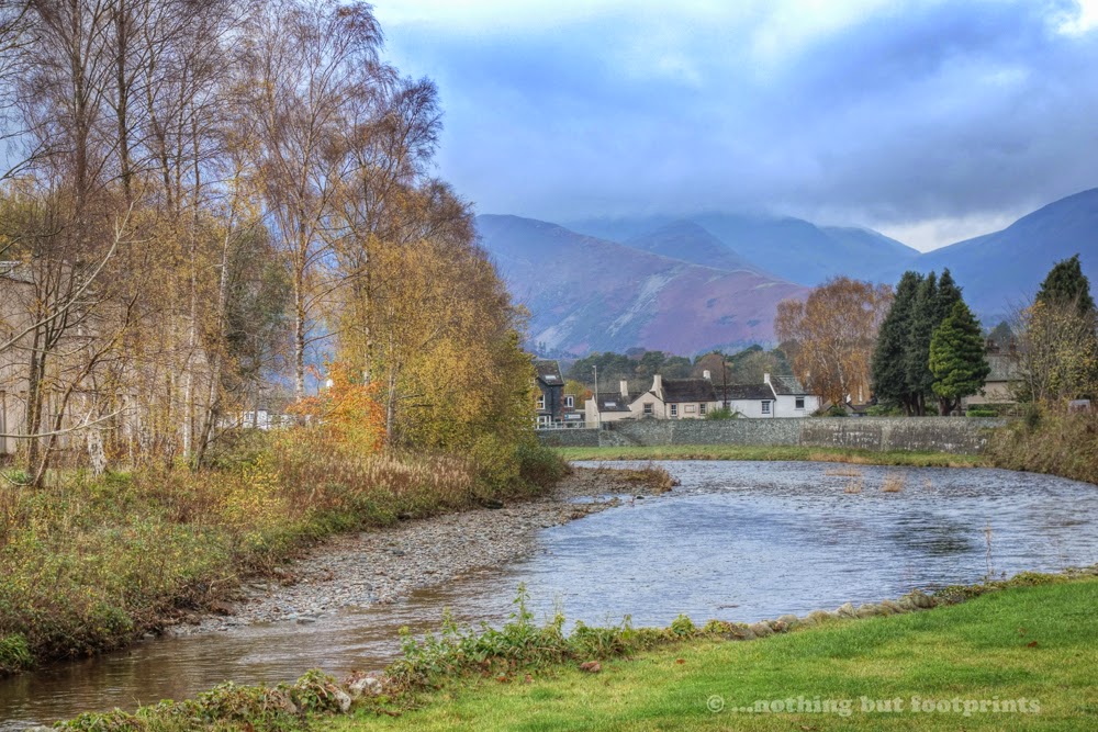
The morning was overcast and a little breezy, but not too cold, as we set off along the banks of the Greta, heading for Spooneygreen Lane and the start of our first ascent of the day. After a short distance I turned back to look in the direction of our guesthouse which looked very pretty behind a foreground of the river and autumn foliage and set against a backdrop of cloud-topped mountains.
Looking back to our accommodation
Walking a little further along the lane gave us a clear view of Latrigg, our first climb of the day. Standing at 1,207 feet (368m), Latrigg is one of the lowest of the Lakeland Fells and perhaps the most accessible of all the Wainwrights. Although we were going to walk from Keswick, many people prefer to drive to the car park which isn't very far from the top of Latrigg and from where there are wheelchair accessible paths all the way to the summit. The most surprising fact, for me, about Latrigg is that in all the times I have visited Keswick, this was to be the first time I had ventured up there.
Latrigg
As we climbed along Spooneygreen Lane and skirted around the base of Latrigg, the sun periodically broke through the clouds, illuminating the slopes of Skiddaw and highlighting the thickness of the cloud cover on top. The landscape was cloaked in autumn tones and we stopped for a while, just to drink in the beauty of our surroundings. Skiddaw is a mountain I am always happy to look upon, whatever the time of year.
Autumn Skiddaw
One of the beauties of Latrigg is that it offers the visitor a wonderful view over Keswick, Derwentwater and the mountains beyond. Although we were denied a clear view of most of the mountains, it was a delight to see Keswick, bathed in a patch of sunlight which was doing its best to break through the thick, glowering clouds. Even at this height it was a lot colder than it had been on the lower ground and so we didn't hang around for long, resolving to return to this point in the summer with the hope of a clearer view.
The view from Latrigg
From the summit of Latrigg we struck off in an easterly direction, heading towards the lower slopes of Lonscale Fell. Our route took us through a field of sheep, clearly so used to human traffic that they didn't even look up from their grazing as we passed. In the background the top of Blencathra was just visible beneath a wispy band of cloud.
Looking towards Lonscale Fell and Blencathra
Before we could begin our next ascent it was necessary to descend from Latrigg, passing through the car park to where the main tourist path to Skiddaw begins, and then turning onto the route of the Cumbrian Way. This path took us down to a crossing of Whit Beck which was flowing swiftly along the col between the lower slopes of Skiddaw Little Man and Lonscale Fell.
Whit Beck
Studying my copy of Wainwright had presented us with several options for a climb of Lonscale Fell. Perhaps the most straightforward route would have been to follow the Skiddaw tourist path as far as Jenkin Hill before taking a right turn, at which point most of the hard work would have been done, leaving us with an easy final ascent. There were also, apparently, a couple of indistinct paths through the bracken after crossing Whit Beck, but as I looked over in that direction all I could see was a sea of autumn-bronzed bracken and a cyclist slowly ascending along the route of the Cumbrian Way. Our fourth option was to follow the same route as the cyclist until the path turned the corner above the Glenderaterra Beck from where we could begin a steep ascent up the side of Lonscale Crags. I took my OS map out of my rucksack and studied the contours for this climb. It was going to be a steep one, but I felt up for the challenge, particularly as I had recently shed just over a stone and a half in weight.
The path below Lonscale Fell (spot the cyclist)
We left the route of the Cumbrian Way after passing through a gate, and immediately our climb began, following the course of a fence in a steep ascent above the rocky face of Lonscale Crags. We had not ascended far before the cloud cover enveloped us, robbing us of a view over the edge of the Crags and concealing the summit from our sight. It was a strenuous climb and the density of the murky clouds meant that as we climbed we had no way of telling how far we may be from the summit.
Into the clouds
Along the way we passed the rotting carcass of a sheep at which point I discovered that it was rather hard to climb and hold your breath at the same time. The need to escape the stench propelled me uphill a little faster until I could go no further and had to stop to gasp in a lungful of uncontaminated air. As I did so a sudden gust of wind lifted the cloud around me and I turned to look down upon Blease Fell and the land below Blencathra lit by sunlight, with the fells above Threlkeld disappearing in the cloud.
A sudden view of Blease Fell
Once the cloud had descended in earnest the visibility was very poor all the way to the summit, where the wind was gusting strongly bringing with it sheets of icy rain. It wasn't a place to hang around and I paused, almost rigid with cold, for a quick snapshot by the summit above East Peak before we hurried on to find our ridge route across to Little Man.
A very cold summit
According to my copy of the Lakeland Fellranger Guide for Lonscale Fell, a hurdle gate in a corner of the fence we had followed to the summit should have led us onto a path towards Jenkin Hill and then onwards to Little Man and the summit of Skiddaw. In the thick cloud cover, however, no such gate was visible and I stopped frequently to consult my map and GPS. Suddenly the path we were following descended very steeply ahead of us and I was now certain that we were heading the wrong way. We were walking in a northerly direction, whilst the summit of Little Man was to the west, and yet all the while a fence barred our way. At this point the cloud cover was so dense that all we could see was the fence to our left and a few feet ahead. The path was very steep and slippery and more than once I lost my footing, sitting down heavily to prevent a downhill roll. It was whilst I was thus seated, recovering from a heavy landing, that the clouds suddenly parted, almost as if accompanied by someone singing "Ta-daaa", at which point a spectacular and very welcome sight was revealed. I remained seated for a little while, reaching for my camera before the cloud descended once more. What I could see was a splendid view of the waters of Roughton Gill cascading down the side of Blease Fell from Blencathra to meet the Glenderaterra Beck. This confirmed that we were now sitting on a crest known as Burnt Horse, this name being a corruption of "Burnt Hause" or "heather-burn pass". From here, I realised, we could descend to meet up with the Cumbrian Way again, just below Skiddaw House.
Ta-daaaa
It wasn't long before our path levelled out to a more comfortable descent. As we left the cloud cover of the higher ground we caught our first glimpse of the Youth Hostel at Skiddaw House, surrounded by sheltering trees.
Heading towards Skiddaw House
Now we were back on the Cumbrian Way again, having re-joined it to the north of Lonscale Fell. From here we were presented with something of a dilemma. I really wanted to visit the summit of Skiddaw again but, as far as I knew, the best route from this point would be to follow the Cumbrian Way northwards as far as Whitewater Dash and then ascend Birkett Edge to Bakestall and on to the top of Skiddaw, descending via the tourist route back to Keswick. It was approaching 3 p.m. and British Summertime had ended a week ago, meaning we would lose light at around 5 p.m. As neither of us had torches with us, the only sensible thing to do was to return to Keswick by following the Cumbrian Way back to where we had started.
As an illustration, I have included below a photo taken in July 2014, approaching from the north and showing the peak of Lonscale Fell with the crest of Burnt Horse just above Skiddaw House. On this image I have marked the route by which we had just descended.
The route of our descent from Lonscale Fell
Our route now followed the rocky path which curves its way around the foot of Lonscale Fell, above the Glenderaterra Beck. Ahead of us the clouds were obscuring a view down the valley of St John's in the Vale, but even so it was a beautiful sight and a joy to be walking along this, one of my favourite paths in Lakeland.
The Cumbrian Way below Lonscale Fell
As Tom walked on ahead of me I took a photograph to compare with one I had taken the last time we followed this route, in July 2014 (on my birthday!). It was nice to contrast the seasonal differences of this wonderful view.
What a difference a day makes (this shot taken in July 2014)
Before we walked around the corner of Lonscale Fell to head back towards Latrigg, I turned to take one last photo of the Glenderaterra Beck rushing along below.
Glenderaterra Beck
A flock of sheep had gathered at the foot of Latrigg as the daylight began to fade. I was struck by the red dye marking their fleeces which almost made them look pink in the late afternoon light. I had recently read that sheep in Lakeland are sometimes given red markings, not to denote ownership but as part of a local practice known as "rudding", an ancient superstition with no known practical purpose (reference Counting Sheep by Phillip Walling).
Night approaches
Our walk concluded with a further ascent of Latrigg before we descended along Spooneygreen Lane, calling in for a very welcome pint at the Pheasant Inn before our return to Keswick.
I was pleased to have been able to tick another two Wainwrights off my list, but still a bit disappointed not to have managed another ascent of Skiddaw, and also a little sad to think that it would be a few months before we'd be able to visit Keswick again. As we returned to our guesthouse later that evening I could see the pinpoints of light emitted from the head torches of those brave enough to climb Skiddaw in the dark. Before we set off home the next day I paid a visit to George Fisher's where I bought myself a Petzl head torch, determined to try a little night walking during the coming winter months and then perhaps next year I too would be able to climb Skiddaw in the dark. Watch this space!
Our route
Coming soon...After a busy festive season, with time for just a few short local walks, we undertake our first proper walk of 2015 with a ten mile circuit following the Pocklington Canal in East Yorkshire.


Comments
Post a Comment