Egton Bridge & Glaisdale Rigg (North York Moors)
Sometimes I have no clue where I would like to go for a walk. As our favoured walking day is Sunday, I usually spend at least an hour on a Saturday evening pouring over my maps and browsing walking sites on the web, searching for inspiration. But sometimes that inspiration just doesn't come. This was the case one Sunday morning in April, when I got up to make breakfast without a single idea where we would be heading. And then I discovered we were out of honey. The decision was made! We would go to Egton Bridge, on the northern edge of the North York Moors, because there, from a little cottage by the river, can be found the finest heather honey money can buy.
Over breakfast I plotted out a circular route from the centre of the village which would take us along the banks of the River Esk to the neighbouring village of Glaisdale, along the high moorland at Glaisdale Rigg and back over Egton High Moor.
It was a lovely spring morning. The sun was shining brightly and it was unseasonably warm, which made a nice change from the rather murky weather we'd been experiencing. It was therefore something of a surprise to find that there were very few people about and we were easily able to find a parking space by the side of the river at Egton Bridge.

We started our walk by crossing the river via two sets of stepping stones which can be found at a point where the river divides. I sometimes find stepping stones a bit unnerving. Even if they're evenly spaced with a flat surface, the fact that there's a river below makes me step very cautiously from one to another, knowing full well all the while that if they were simply rocks placed on a grassy surface then I would bound across them in a much more carefree manner. It's psychological! And, as it turned out, one of the stones right in the middle was particularly slippery, so my caution was not misplaced on this occasion.

Having made it to the other side without a dunking, we followed the course of the Esk Valley Walk along a quiet country lane in the direction of Glaisdale, enjoying the sight of new born lambs in the warm Spring sunshine.

After about half a mile or so we turned to follow a path through East Arncliff Wood, still following the Esk Valley Walk, a long distance path of 37 miles which follows the course of the River Esk from its source on the moors above Castleton to where it flows into the North Sea at Whitby. To begin with the path through the trees was very wet and boggy in places.

A little further into the woods and the walk became much cleaner and easier, thanks to a series of ancient paving slabs, known as "trods". This ancient form of paving can be found in several places across the North York Moors and the oldest examples date from medieval times. The slabs in East Arncliff Wood are known as the "Monks' Trod" and are believed to have led to the former St Hilda's Church which was dismantled in 1871.

The path through the trees gradually descended until it reached the banks of the River Esk, where the still waters were lined with occasional clumps of daffodils, looking very pretty indeed in the Spring sunshine.
The River Esk is a very clean and healthy river, supporting a large variety of wildlife. It is also the only river in Yorkshire where both salmon and sea trout thrive. It also supports the last surviving, but dwindling, population of freshwater pearl mussels in Yorkshire.

As we walked along the riverbank a sudden movement on the path caught my eye and I stopped in my tracks, just in time to avoid stepping on a Common Toad. He was sitting right in the middle of the path, partially camouflaged by mud and so we carefully picked him up and set him down in a much safer place. He was quite a handsome chap and didn't seem at all fazed by this sudden interruption to his previously peaceful Sunday morning.

The path left the wood via a series of stone steps, emerging at a ford over a tributary stream, which was conveniently placed for rinsing some of the mud which had inevitably accumulated on our boots. Judging by the depth gauge at the side of the ford, sometimes it may be necessary to swim over, but on this occasion it was shallow enough to easily wade across.

Just beyond the ford we passed the legendary Beggar's Bridge, arguably the most romantic place in the whole of the North York Moors. A stone on the crest of the bridge's parapet is inscribed with the initials 'TF' and the date '1619'. The initials are those of the "beggar" in question, one Thomas Ferries, the impoverished son of a moorland sheep farmer, and the date of 1619 was the year in which he had this bridge built. Legend has it that Thomas met Agnes Richardson, the daughter of a wealthy Glaisdale farmer, at an annual fair in Whitby. The couple fell in love, but Agnes' father said that he would not permit his daughter to marry a mere beggar. Undeterred, Thomas persuaded Mr Richardson to consent to the marriage on the condition that he would go to sea and return a wealthy man. In 1586 Thomas set sail from Whitby in a ship which joined the English fleet that conquered the Spanish Armada, earning Thomas the praise of none other than Sir Francis Drake. He then went on to sail with Drake to the West Indies where he earned his fortune as a pirate, returning to Glaisdale in 1592 having acquired enough wealth to enable him to marry Agnes. Thomas is supposed to have commissioned the building of this bridge to mark the spot where he had previously had to swim across the river to meet Agnes in secret, their story commemorated in an old poem:
The rover came back from a far distant land,
And claimed from the maiden her long-promised hand.
But he built ere he won her the bridge of his vow,
And the lovers of Egton pass over it now.

Our route didn't continue over the bridge, but I walked out into the middle and spared a thought for Thomas and Agnes before continuing back along the road and into the village of Glaisdale.
The sun was shining brightly as we climbed away from the village and the light cloud cover from earlier in the day had all but dispersed. As we gradually ascended towards the higher moorland we had a clear view all the way across to a distant Robin Hood's Bay and the sea beyond. There was hardly a breath of wind and the temperature began to grow unseasonably warm.

Looking over to the north we also had an excellent view across Glaisdale Moor.

As we began to follow a track higher up onto the open moors we passed a small area of wetland teeming with frogs. They seemed to be everywhere - sitting on the path, basking in the sunshine or swimming in the little ponds by the side of the track. It was fascinating to watch them and some of them looked quite comical as they skimmed straddle-legged across the surface of the water.

After passing through a gate we emerged on to Glaisdale Rigg, a stony track which traverses the top of Glaisdale Moor and forms one of the final sections of the Coast to Coast Walk (for those walking west to east, that is).

Along the way we passed some of the standing stones which can be found across the North York Moors, serving as boundary markers or milestones. From this vantage point we also had an excellent view down into the valley of Glaisdale and across to Egton High Moor, which we would later be passing over on our return route to Egton Bridge.

Sometimes the moorland milestones have crude yet decipherable writing still visible, despite the weathering of passing centuries, and further along the rigg we came across one such stone on which it was just possible to make out the inscription "Whitby Road". I really like these old stones. They always make me pause to think of all the packhorses, drovers, stagecoaches and long-dead people who have passed this way before me, in the days when a track such as this would have been the "motorway" of its time.

We walked for a couple of miles along Glaisdale Rigg, occasionally passing way-markers of a more modern origin, directing walkers to various public footpaths leading away from the track. As we neared the end of the rigg I turned to look back along the route we had taken and to the sea on the distant horizon. It was the perfect kind of day to be out on the moorland and, remarkably, there wasn't another soul in sight.

As we approached the end of the track we passed a direction sign for the Coast to Coast Walk. With just a few miles to go to the traditional finishing point at Robin Hood's Bay, this must be a sometimes welcome, sometimes sad point for the many hundreds of people who follow this 192 mile long route from west coast to east. We thought the sign looked rather lonely and couldn't resist the urge to liven it up a bit, if only for just one photo.

At the end of Glaisdale Rigg we turned to follow a grassy path downhill, into the valley of Glaisdale. From this point we could already see the path we would be taking up out of the valley, which lay to the right of the two wooded areas on the hillside across the valley.

Below us lay the green, fertile valley of Glaisdale, a scene typical of the rigg and dale landscape of the North York Moors.

At the foot of the hill we walked along a quiet country lane, lined with daffodils. It was such a lovely day and the temperature was beginning to soar, yet still we hadn't seen anyone else. No people, cars or even cyclists. I couldn't imagine such a day in other national parks, like the Lake District for instance, being so blissfully silent, save for the occasional honking of a pheasant or bleating of sheep.

We followed a narrow lane for a mile or so, heading in the direction of Glaisdale Head from where we began our climb onto Egton High Moor. Along the way we passed a field of lambs - I counted 14 of them, but curiously only two adult sheep were visible. Was this a day nursery for lambs, I wondered, or was I looking at two particularly prolific ewes? They all looked very relaxed anyway, basking in the Spring sunshine.

Our route up the side of Wintergill Plantation was rather steep and hot work in the blazing afternoon sunshine, but the lovely views back down Glaisdale provided me with a good enough excuse to stop every few paces. Even so I seemed to be disproportionately out of breath by the time I reached the top and found myself a large rock on which to sit and take a short break.

After a short section of road walking we turned to follow a track which led across Egton High Moor, an area of approximately 4,900 acres of heather moorland which is designated as a Site of Special Scientific Interest.

The track led us over an area known for its peat bogs which were in evidence at both sides of the track. As we walked along we passed areas known as Pike Hill Moss and Mirk Mire Moor, both seeming to fittingly describe this boggy area of upper moorland.

Once we had crossed Egton High Moor and its boggy pools, we turned onto a muddy farm track which led downhill back in the direction of Egton Bridge.

The track took us through a farmyard where a group of cows peered out at us from behind the iron bars of their barn. They were the cleanest cows I've ever seen and they eyed me curiously as I edged closer to take a photo.

Shortly after the farm with the very clean cows we emerged back onto the lane into Egton Bridge, crossing the stepping stones again which led us to Mill Cottage, the source of the best heather honey in Yorkshire. I was relieved to see that the "Honey for sale" sign was out by the roadside and shortly afterwards we were driving home again, stocked up with several jars of the richest, tastiest honey that you are ever likely to find. We enjoy eating this honey every day, so it won't last us long. All the more reason to plan another walk in this lovely, peaceful corner of the North York Moors.


Coming soon.... Even though I've got several walks to write blogs about from April and May, I'm going to interrupt the flow of things and jump forwards to June for my next blog. This is because we have just completed the Dales Way - 82 miles from Ilkley in West Yorkshire to Bowness-on-Windermere. It was a truly amazing walk and I can't wait to share it. Once I've written a day-by-day account of this wonderful long distance walk, then I'll return to writing about the lovely walks we undertook in April and May. In the meantime, I regularly share mini updates and photos on my Facebook page.
Over breakfast I plotted out a circular route from the centre of the village which would take us along the banks of the River Esk to the neighbouring village of Glaisdale, along the high moorland at Glaisdale Rigg and back over Egton High Moor.
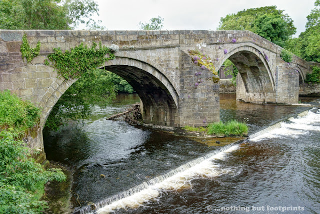
It was a lovely spring morning. The sun was shining brightly and it was unseasonably warm, which made a nice change from the rather murky weather we'd been experiencing. It was therefore something of a surprise to find that there were very few people about and we were easily able to find a parking space by the side of the river at Egton Bridge.

The River Esk at Egton Bridge
We started our walk by crossing the river via two sets of stepping stones which can be found at a point where the river divides. I sometimes find stepping stones a bit unnerving. Even if they're evenly spaced with a flat surface, the fact that there's a river below makes me step very cautiously from one to another, knowing full well all the while that if they were simply rocks placed on a grassy surface then I would bound across them in a much more carefree manner. It's psychological! And, as it turned out, one of the stones right in the middle was particularly slippery, so my caution was not misplaced on this occasion.

Egton Bridge Stepping Stones
Having made it to the other side without a dunking, we followed the course of the Esk Valley Walk along a quiet country lane in the direction of Glaisdale, enjoying the sight of new born lambs in the warm Spring sunshine.

View from the roadside
After about half a mile or so we turned to follow a path through East Arncliff Wood, still following the Esk Valley Walk, a long distance path of 37 miles which follows the course of the River Esk from its source on the moors above Castleton to where it flows into the North Sea at Whitby. To begin with the path through the trees was very wet and boggy in places.

Muddy path in East Arncliff Wood
A little further into the woods and the walk became much cleaner and easier, thanks to a series of ancient paving slabs, known as "trods". This ancient form of paving can be found in several places across the North York Moors and the oldest examples date from medieval times. The slabs in East Arncliff Wood are known as the "Monks' Trod" and are believed to have led to the former St Hilda's Church which was dismantled in 1871.

The Monks' Trod
The path through the trees gradually descended until it reached the banks of the River Esk, where the still waters were lined with occasional clumps of daffodils, looking very pretty indeed in the Spring sunshine.
The River Esk is a very clean and healthy river, supporting a large variety of wildlife. It is also the only river in Yorkshire where both salmon and sea trout thrive. It also supports the last surviving, but dwindling, population of freshwater pearl mussels in Yorkshire.

Springtime by the River Esk
As we walked along the riverbank a sudden movement on the path caught my eye and I stopped in my tracks, just in time to avoid stepping on a Common Toad. He was sitting right in the middle of the path, partially camouflaged by mud and so we carefully picked him up and set him down in a much safer place. He was quite a handsome chap and didn't seem at all fazed by this sudden interruption to his previously peaceful Sunday morning.

Common Toad
The path left the wood via a series of stone steps, emerging at a ford over a tributary stream, which was conveniently placed for rinsing some of the mud which had inevitably accumulated on our boots. Judging by the depth gauge at the side of the ford, sometimes it may be necessary to swim over, but on this occasion it was shallow enough to easily wade across.

A shallow ford
Just beyond the ford we passed the legendary Beggar's Bridge, arguably the most romantic place in the whole of the North York Moors. A stone on the crest of the bridge's parapet is inscribed with the initials 'TF' and the date '1619'. The initials are those of the "beggar" in question, one Thomas Ferries, the impoverished son of a moorland sheep farmer, and the date of 1619 was the year in which he had this bridge built. Legend has it that Thomas met Agnes Richardson, the daughter of a wealthy Glaisdale farmer, at an annual fair in Whitby. The couple fell in love, but Agnes' father said that he would not permit his daughter to marry a mere beggar. Undeterred, Thomas persuaded Mr Richardson to consent to the marriage on the condition that he would go to sea and return a wealthy man. In 1586 Thomas set sail from Whitby in a ship which joined the English fleet that conquered the Spanish Armada, earning Thomas the praise of none other than Sir Francis Drake. He then went on to sail with Drake to the West Indies where he earned his fortune as a pirate, returning to Glaisdale in 1592 having acquired enough wealth to enable him to marry Agnes. Thomas is supposed to have commissioned the building of this bridge to mark the spot where he had previously had to swim across the river to meet Agnes in secret, their story commemorated in an old poem:
The rover came back from a far distant land,
And claimed from the maiden her long-promised hand.
But he built ere he won her the bridge of his vow,
And the lovers of Egton pass over it now.

Beggar's Bridge
Our route didn't continue over the bridge, but I walked out into the middle and spared a thought for Thomas and Agnes before continuing back along the road and into the village of Glaisdale.
The sun was shining brightly as we climbed away from the village and the light cloud cover from earlier in the day had all but dispersed. As we gradually ascended towards the higher moorland we had a clear view all the way across to a distant Robin Hood's Bay and the sea beyond. There was hardly a breath of wind and the temperature began to grow unseasonably warm.

A view to the sea
Looking over to the north we also had an excellent view across Glaisdale Moor.

Glaisdale Moor
As we began to follow a track higher up onto the open moors we passed a small area of wetland teeming with frogs. They seemed to be everywhere - sitting on the path, basking in the sunshine or swimming in the little ponds by the side of the track. It was fascinating to watch them and some of them looked quite comical as they skimmed straddle-legged across the surface of the water.

Swimming frog
After passing through a gate we emerged on to Glaisdale Rigg, a stony track which traverses the top of Glaisdale Moor and forms one of the final sections of the Coast to Coast Walk (for those walking west to east, that is).

On Glaisdale Rigg
Along the way we passed some of the standing stones which can be found across the North York Moors, serving as boundary markers or milestones. From this vantage point we also had an excellent view down into the valley of Glaisdale and across to Egton High Moor, which we would later be passing over on our return route to Egton Bridge.

Moorland stone on Glaisdale Rigg
Sometimes the moorland milestones have crude yet decipherable writing still visible, despite the weathering of passing centuries, and further along the rigg we came across one such stone on which it was just possible to make out the inscription "Whitby Road". I really like these old stones. They always make me pause to think of all the packhorses, drovers, stagecoaches and long-dead people who have passed this way before me, in the days when a track such as this would have been the "motorway" of its time.

Whitby Road milestone
We walked for a couple of miles along Glaisdale Rigg, occasionally passing way-markers of a more modern origin, directing walkers to various public footpaths leading away from the track. As we neared the end of the rigg I turned to look back along the route we had taken and to the sea on the distant horizon. It was the perfect kind of day to be out on the moorland and, remarkably, there wasn't another soul in sight.

Looking back down Glaisdale Rigg
As we approached the end of the track we passed a direction sign for the Coast to Coast Walk. With just a few miles to go to the traditional finishing point at Robin Hood's Bay, this must be a sometimes welcome, sometimes sad point for the many hundreds of people who follow this 192 mile long route from west coast to east. We thought the sign looked rather lonely and couldn't resist the urge to liven it up a bit, if only for just one photo.

On the Coast to Coast route
At the end of Glaisdale Rigg we turned to follow a grassy path downhill, into the valley of Glaisdale. From this point we could already see the path we would be taking up out of the valley, which lay to the right of the two wooded areas on the hillside across the valley.

The path down from Glaisdale Rigg
Below us lay the green, fertile valley of Glaisdale, a scene typical of the rigg and dale landscape of the North York Moors.

The Glaisdale valley
At the foot of the hill we walked along a quiet country lane, lined with daffodils. It was such a lovely day and the temperature was beginning to soar, yet still we hadn't seen anyone else. No people, cars or even cyclists. I couldn't imagine such a day in other national parks, like the Lake District for instance, being so blissfully silent, save for the occasional honking of a pheasant or bleating of sheep.

A peaceful lane
We followed a narrow lane for a mile or so, heading in the direction of Glaisdale Head from where we began our climb onto Egton High Moor. Along the way we passed a field of lambs - I counted 14 of them, but curiously only two adult sheep were visible. Was this a day nursery for lambs, I wondered, or was I looking at two particularly prolific ewes? They all looked very relaxed anyway, basking in the Spring sunshine.

So many lambs, so few ewes
Our route up the side of Wintergill Plantation was rather steep and hot work in the blazing afternoon sunshine, but the lovely views back down Glaisdale provided me with a good enough excuse to stop every few paces. Even so I seemed to be disproportionately out of breath by the time I reached the top and found myself a large rock on which to sit and take a short break.

View from Wintergill Plantation
After a short section of road walking we turned to follow a track which led across Egton High Moor, an area of approximately 4,900 acres of heather moorland which is designated as a Site of Special Scientific Interest.

Crossing Egton High Moor
The track led us over an area known for its peat bogs which were in evidence at both sides of the track. As we walked along we passed areas known as Pike Hill Moss and Mirk Mire Moor, both seeming to fittingly describe this boggy area of upper moorland.

Peat bogs
Once we had crossed Egton High Moor and its boggy pools, we turned onto a muddy farm track which led downhill back in the direction of Egton Bridge.

Muddy track downhill
The track took us through a farmyard where a group of cows peered out at us from behind the iron bars of their barn. They were the cleanest cows I've ever seen and they eyed me curiously as I edged closer to take a photo.

Very clean cows
Shortly after the farm with the very clean cows we emerged back onto the lane into Egton Bridge, crossing the stepping stones again which led us to Mill Cottage, the source of the best heather honey in Yorkshire. I was relieved to see that the "Honey for sale" sign was out by the roadside and shortly afterwards we were driving home again, stocked up with several jars of the richest, tastiest honey that you are ever likely to find. We enjoy eating this honey every day, so it won't last us long. All the more reason to plan another walk in this lovely, peaceful corner of the North York Moors.

Yum!
Total distance walked - 13 miles.

Coming soon.... Even though I've got several walks to write blogs about from April and May, I'm going to interrupt the flow of things and jump forwards to June for my next blog. This is because we have just completed the Dales Way - 82 miles from Ilkley in West Yorkshire to Bowness-on-Windermere. It was a truly amazing walk and I can't wait to share it. Once I've written a day-by-day account of this wonderful long distance walk, then I'll return to writing about the lovely walks we undertook in April and May. In the meantime, I regularly share mini updates and photos on my Facebook page.

Comments
Post a Comment