Posts

Showing posts from December, 2013

Whernside (Yorkshire Three Peaks)
Image
As 2013 drew to a close I realised I had unfinished business in the Yorkshire Dales.   There was one of Yorkshire's Three Peaks which I had yet to climb.   The highest of the three - Whernside. The idea of climbing all three in the same year appealed to me and so I decided to waste no further time.   As the weather forecast for the second weekend in November seemed reasonably favourable, we headed west again, initially to the Wensleydale village of Hawes.   Although we could have easily driven directly to Whernside, climbed the mountain and driven home again in the same day, the chance to spend a little longer in the Yorkshire Dales is one we’d seldom pass by.   And Hawes is home to two of our favourite places to visit in the Dales – the Wensleydale Creamery and the Wensleydale Pantry.   The “Pantry” is a little restaurant in Hawes which offers the most comprehensive menu I’ve ever seen, from cooked breakfasts to curries, steak dinners, pasta, cakes, pastries – just about anyt

The Bridestones (North York Moors)

Image
The main focus for our first walk in November was the group of rock formations known as the Bridestones which are in the North York Moors National Park on the edge of Dalby Forest.   Setting off from the car park at the Hole of Horcum, our walk was a circuit of nine miles which started by following an ancient track known as the Old Wife’s Way.   Today this is a popular cycle track across the moors, but the origins of the name probably refer to ancient fertility rites associated with an earth mother or goddess known as “the old wife”, and the track actually leads to a group of ancient standing stones.   On this particular windy November day, however, we only followed it for a short distance before turning off towards the forest. Dalby Forest covers a total of 8,000 acres and is known as the Great Yorkshire Forest.   In the care of the Forestry Commission, it’s a popular place with a visitor centre, cycle tracks, footpaths, adventure playgrounds and lots of public events thr

Grisedale Pike (Lake District)

Image
Day two of our short stay in the Lake District started with a dilemma.   I had set out on our weekend break with the intention of climbing one of the larger mountains for which the Lake District is famous.   My preferred mountain of choice was Great Gable (2,949 feet), with the intention of ascending from Seathwaite in Borrowdale.   However, as our accommodation for the weekend was located in the village of Braithwaite, at the foot of Grisedale Pike, this slightly smaller mountain was held in reserve. As it turned out, day two dawned with overcast skies and looking down towards the direction of Great Gable, through Borrowdale and beyond, we could see the clouds were hanging heavily over the mountain tops, meaning the majority of any climb would be undertaken in damp conditions with poor visibility.     Whilst I didn’t mind this so much, I remembered our recent ascent of Skiddaw in similar conditions.   Although this climb had been highly enjoyable, it was nevertheless a bit disa

Helm Crag (Lake District)

Image
I have wanted to climb a Lake District mountain for as long as I can remember.   Until September this year, however, it had been one of those ambitions I just hadn’t worked hard enough to achieve.   There was always an excuse.   I wasn’t fit enough.   I didn’t have time to prepare.   The weather in the Lake District is too unpredictable (it is a bit of a watershed).   Other holiday destinations took precedence.   Excuse after excuse!   I mention this to highlight just how much my climb of Skiddaw meant to me.   It was hard work and it was wonderful.   And it left me wanting more.   Which is why, just three weeks later, I found myself on the road at 6 a.m., driving westwards towards the Lake District again. This time I had several peaks in mind.   I didn’t intend climbing all of them, but had decided to leave my final decision as to which of them I would tackle until we arrived in Lakeland.   The weather forecast was promising, but I realised that where the Lake District is conc

Sutton Bank (North York Moors)

Image
Sutton Bank marks the western edge of the North York Moors.   Also known as Roulston Scar, its 1 in 4 (25%) gradient and hairpin bends make it a formidable hazard for motor vehicles.   Lorries frequently become stuck and caravans are prohibited from using this section of the A170.     However, Sutton Bank also provides what many believe to be the finest view in the whole of Yorkshire, looking over Hood Hill and Lake Gormire, across the Vale of York and the Vale of Mowbray to the distant Pennines.   It is one of our very favourite places. The view of Lake Gormire and Hood Hill from Sutton Bank On the first Sunday in October we left our car at the National Park Visitor Centre at the top of Sutton Bank and headed off on a circular walk of 12 miles, beginning with a very pleasant stroll through Hambleton Plantation where I was delighted to find an abundance of Amanita Mushrooms, commonly known as Fly Agaric, the quintessential toadstool.   I had never actually seen these before e

A weighty problem

Image
I love my camera.   It doesn't quite go everywhere with me, but if I'm going on a walk I definitely want to take it along.   This isn't just so that I can take images to use in my blog, although since I began blogging earlier in the year I have been taking even more photos than usual.   The main reason I want my camera along though is because I make a portion of my income from the sale of stock images and so it's important that I never miss a shot.     As a semi-professional photographer I have a good DSLR camera with an excellent set of lenses.   My camera body is the Canon EOS 5D Mark II and my main "walk-about" lens of choice is the 24-105 L series.   This might not mean anything to any non-photographer readers of my blog, but to put it simply it's a bit of a beast, weighing in at approximately 4lbs.   When that's added to everything else I carry in my rucksack (drinks, waterproofs, etc) it makes for quite a heavy load.   I've certainly f

Bransdale & Rudland Rigg (North York Moors)

Image
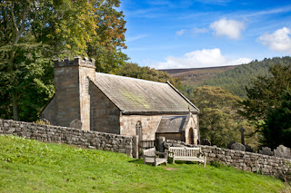
The last weekend of September found us walking a little closer to home, in the North York Moors National Park at Bransdale, which is considered to be the most isolated of the moorland valleys.   We began our nine mile circular walk from the hamlet of Cockayne, parking by the   little church of St Nicholas.   Although there has been a church on this site since the late 13th century, the present building was erected in 1886 and was extended in 1934.   It's what's known as a chapel of ease, which means that it's a small church built within the parish of a larger church for the "ease" of those who are unable to travel to the main church.   In this case the main parish church is All Saints, Kirbymoorside, a distance of some nine miles away, across isolated moorland.   St Nicholas Church, Cockayne From the church we walked along the road and across a field to Bransdale Mill, an 18th century watermill currently in the ownership of the National Trust and us