Bransdale & Rudland Rigg (North York Moors)
The last weekend of September found us walking a little
closer to home, in the North York Moors National Park at Bransdale, which is
considered to be the most isolated of the moorland valleys.
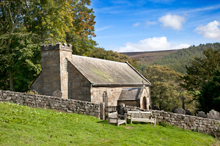


We began our nine mile circular walk from the hamlet of
Cockayne, parking by the little church
of St Nicholas. Although there has been
a church on this site since the late 13th century, the present building was
erected in 1886 and was extended in 1934.
It's what's known as a chapel of ease, which means that it's a small
church built within the parish of a larger church for the "ease" of
those who are unable to travel to the main church. In this case the main parish church is All
Saints, Kirbymoorside, a distance of some nine miles away, across isolated
moorland.

St Nicholas Church, Cockayne
From the church we walked along the road and across a field
to Bransdale Mill, an 18th century watermill currently in the ownership of the
National Trust and used today as a bunkhouse.
In the early 19th century the mill was owned by a William Strickland of
Farndale whose initials W.S. are displayed in iron lettering along with an
inscription to the effect that he rebuilt the mill in 1812.

Bransdale Mill
A short distance from the buildings, in a field overlooking
the mill, I discovered a sundial bearing the inscription "Time and life
move swiftly". I took a few
photographs of the mill and the sundial with the intention of trying to find
out more upon my return home.
Disappointingly, I haven't been able to find out very much at all about
the Stricklands of Bransdale. All I've
discovered so far is that William Strickland's son Emmanuel, who for a short time was the
Curate at Ingleby Greenhow, was responsible for a number of inscriptions at
Bransdale Mill. And a little further on
the walk another curious inscription turned up...more on this later!

Sundial, Bransdale Mill
From Bransdale Mill our walk returned us to the road and
then onto the high moorland between Bransdale and Farndale. Here the road between the heather climbed
steadily over Shaw Ridge, past lines of grouse butts and eventually onto
Rudland Rigg. Here we turned onto the
old coaching road known as the Waingate, which leads from Kirbymoorside to
Stokesley. I was keen to photograph one
of the old stone waymarkers which were erected to guide travellers across this
isolated section of moorland. This one
is inscribed "Kirby Rode" on one side (road to Kirbymoorside) and, less
distinctly on the other side "Stoxle Rode" (meaning Stokesley
road). 
Waymarker on the Waingate, Rudland Rigg
The name "Waingate" derives from the Anglo-Saxon
name for wagons, the wain (as in "haywain" or "wainwright")
and on this ancient isolated track it was easy to imagine packhorses, wagons
and stagecoaches transporting food, wool, timber and passengers. Rudland Rigg would have been the motorway of
its day!
A mile or so further along the Waingate sits the Cammon
Stone ("common" stone), a single standing stone dating from the
Bronze Age. The stone stands at
approximately 1.6 meters high, has a cleft down the centre and is inscribed
with curious lettering which translates from Hebrew to the word "hallelujah
".
This, like the inscriptions at Bransdale Mill, is believed to be the
work of Emmanuel Strickland and, looking at the wonderful views over Farndale,
it's easy to see why this particular word sprang to mind.
The Cammon Stone

Hebrew "Hallelujah" inscribed on Cammon Stone
We continued along our route until the national trail the
Cleveland Way crossed the Waingate at Bloworth Crossing. Here the Rosedale Ironstone Railway crossed
the Waingate as it headed towards Ingleby Incline above Ingleby Greenhow (home
to Emmanuel Strickland). Ingleby
Incline is 1430 yards long and ascends to an altitude of 1370ft at the top
starting at 1 in 11 gradient steepening to 1 in 5 by the top. Little wonder then that there was once a rope
shed at Bloworth, where ropes were stored to pull the engines. Today the only evidence of the railway are
the remains of some sleepers at the crossing point. From here the Cleveland Way follows the track
of the former railway line, heading off to the left on my photo below, whilst the Waingate continues winding its way over the moors towards Stokesley.

Bloworth Crossing
We retraced our steps back along Rudland Rigg for a short
while before taking a track down into Bloworth Woods. The woods here are owned by the Forestry
Commission and although the track is not a public right of way it's what's known
as a permissive footpath which enabled us to cut back towards Cockayne, passing
signs of intensive forestry work.

Forestry work in Bloworth Wood
This was my first every visit to Bransdale. After the busy footpaths and hills of the
Lake District it was pleasant to walk in such a peaceful and isolated area, and I'm sure we will
return here again before too long.


If you read one of Herbert Read's autobiographies "The innocent eye" "Annals of innocence and experience" "The contrary experience" you'll find that the Bransdale Mill (as well as the Howkeld Mill downstream on Hodge Beck) used to belong to relatives on his mother's side.
ReplyDelete