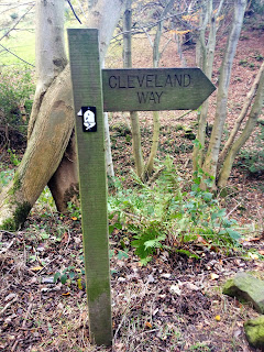
Cloughton to Robin Hood's Bay on the Cleveland Way
Here we are, two weeks into 2014 and I still have four walks
remaining from 2013 to write about before I'll be up to date. So, without further ado, there follows an
amalgamation of two walks into one, covering a section of the Cleveland Way in
North Yorkshire.


One of the problems with walking at this time of year is
that the ground underfoot can be very soggy, if not impassable in places, and
so towards the end of November I did a little research in an attempt to find a
route that might be relatively firm and dry.
It didn't take long to find the perfect spot, not too far from home,
being a section of the Cleveland Way from Cloughton (just north of Scarborough)
to Robin Hood's Bay.
The Cleveland Way is a National Trail of 110 miles which
begins in the North Yorkshire market town of Helmsley and ends on the coast at
Filey Brigg. It's very much a trail of
two halves, with the first section following the Cleveland Hills along the edge
of the North York Moors National Park before joining the coast for the second
half along the Heritage Coast from Saltburn in the north to Filey in the
south. We walked approximately 10 miles
of the coastal section over the course of two weekends, making each walk a
circular route (of 12 miles and 9 miles respectively) by also following a path known as the "Cinder
Track". This is the route of the
old Scarborough to Whitby railway which ran from 1885 until 1965 and today is
used as an off-road route by walkers, horse riders and cyclists. As the name suggests, the track was originally
covered in ballast made from cinders and, although there are occasional muddy
sections, mostly the walking conditions are very easy. Also, with it having once been a railway,
none of the inclines are particularly steep which makes for a pleasant and easy
walk.

The Cinder Track
Our first walk began at Cloughton which is a small village
situated four miles to the north of Scarborough. On this walk we began by following the Cinder
Track for just over five miles to the village of Ravenscar. Known locally as "the town that never
was", until the end of the 19th century Ravenscar was called Peak. The name was changed when a local
entrepreneur decided to turn the village into a seaside town to rival the likes
of nearby Scarborough and so a large hotel was opened in 1895, followed by a
golf course in 1898. And so Peak became Ravenscar so as not to confuse it with the already popular
Derbyshire Peak District. Roads and
sewers were built and plots of land sold to city dwellers for the construction
of holiday homes. However the plans were
all doomed to failure, mostly because of the precarious nature of the route to
the nearest beach and in 1913 the development company folded after only a few
houses had been built. Today Ravenscar
is a strange place, its wide roads, abandoned railway line and a few large houses
designed to be part of a town look oddly out of place on this remote and
beautiful stretch of coastline.

Former railway station on the Cinder Track
From Ravenscar we left the Cinder Track and joined the
Cleveland Way to return to Cloughton.
This stretch of coast was both beautiful and intriguing. Looking down from the clifftop we could see
what's known as an undercliff, which is to say the cliff below our feet dropped
away to a broad ledge of woodland with a further cliff below that, the overall effect
appearing positively Jurassic. This
section of coast is known as Beast Cliff and is a Site of Special Scientific
Interest, in the care of the National Trust.
From above it looked as if there may be paths through the woodland,
which is somewhere to possibly explore at a later date, but as the hours of
daylight are short at this time of year, we continued back towards Cloughton. The sun came out briefly, providing some much
needed light for a photo, but sadly it didn't stay out for long.

On the Cleveland Way between Ravenscar and Cloughton
Hayburn Wyke is a delightful secluded little bay surrounded
by woodland walks, with a waterfall cascading onto boulders just above the
beach. By the time we'd reached here the
sun was hidden behind clouds again and so we continued on our way towards
Cloughton, making a note to return in better conditions.

Hayburn Wyke
We left this stretch of the Cleveland Way at Cloughton Wyke
(in Yorkshire dialect "wyke" means small bay) just as the daylight
was beginning to fade.

Cloughton Wyke
As this had been such a pleasant and easy walk for this time
of year, we returned to Ravenscar the following weekend to walk in the opposite
direction, this time starting out on the Cleveland Way and walking for four
miles up to the beautiful little village of Robin Hood's Bay. It was very overcast and windy, so I took the
decision to leave my camera at home.
Consequently the only images I have were taken with my iphone.

Approaching Robin Hood's Bay
I've often wondered how Robin Hood's Bay came by its name,
seeing as it is over 100 miles away from Sherwood Forest and hardly likely to
have been a regular haunt of the legendary outlaw. There are various theories on the matter, the
most likely explanation being that the name derives from the legend of an
ancient tree spirit called Robin Goodfellow and over the centuries this has
been gradually transformed into the more widely known Robin Hood. It's all very vague, but one fact that's
known for certain about Robin Hood's Bay is that in the 18th century it had the
busiest smuggling community on the whole of the Yorkshire coast. As you wander round its narrow alleyways it's
not difficult to imagine the pitched battles that frequently took place between
the local smugglers and the excise men.

Alleyway in Robin Hood's Bay
Today this lovely little village is mostly busy with tourists, even in the winter, and it's also well known
for being the traditional finishing point of the Coast to Coast Walk. Not an official National Trail, the Coast to
Coast was created by Alfred Wainwright in 1973.
The 192 mile walk begins at St Bee's in Cumbria, crossing three National
Parks (the Lake District, the Yorkshire Dales and the North York Moors) before
finishing at Robin Hood's Bay. The
traditional way to finish the walk is to dip your feet in the North Sea, having
done so in the Irish Sea at the start of the walk, and then leave a pebble on
the beach which you picked up at St Bee's.
I'd like to bet that the next priority after this will be a visit to the
appropriately named Wainwright's Bar. It
would be for me!

Wainwright's Bar at the end of the Coast to Coast
Our walk back from Robin Hood's Bay to Ravenscar was along
the Cinder Track. As the wind gathered
strength I was grateful of the shelter the old railway embankment provided and
the five and a half miles were covered quite quickly and comfortably.
Both of my walks along this stretch of the Yorkshire coast
left me feeling I'd missed out on some excellent photographic
opportunities. The walks had been highly
enjoyable and so I've made a note to return in the spring or summer when the
days are longer and the light should be more favourable.


Comments
Post a Comment