Hadrian's Wall
As the Christmas holidays approached and the annual hint of
panic began to creep in (presents to buy, cards to write, cakes to bake and all
that stuff), I couldn't see how we could find the time to go off walking amidst
all the preparations. Then I had a
brainwave. Why not combine the two? A favourite walk AND a Christmas shopping
trip. Hadrian's Wall provided the ideal
solution - a walk along the wall followed by a night at my "hotel of the
year" (The Centre of Britain, Haltwhistle) combined with a trip to the
Metro Centre shopping mall at nearby Gateshead.
Perfect! And so that's just what
we did, setting off very early on the first Saturday morning in December,
arriving at a frosty Once Brewed Visitor Centre at around 10 a.m. From here we set off on an eight mile
circular route which we'd walked earlier in the year. I don't usually provide route directions (this
isn't, after all, just a blog about
walking) but here I'm going to break with that tradition because this is such a
great walk and so easy to follow. A map
isn't even really necessary, except perhaps for the latter part of the walk
which heads away from the wall.
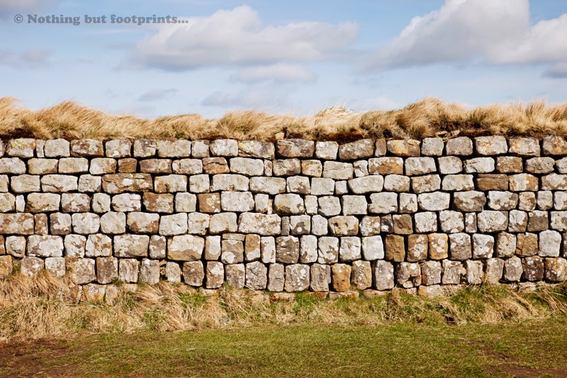


A section of Hadrian's Wall
The walk starts and ends at the Once Brewed National ParkVisitor Centre (car park, toilets and refreshments available) which is located
near Haltwhistle on the B6318. This is
known as the Military Road which, seeing as it runs for most of its length
along the wall, may instantly conjure up images of marching Roman legions. Not
so! It was actually constructed in 1746
by General Wade in the wake of the Jacobite Rebellion of 1745 and, sadly, a lot
of the hardcore for its foundations was taken from parts of the wall. There are some very long, straight sections
along which traffic tends to travel at high speeds, so great care is needed
when crossing from the Visitor Centre to a quiet, narrow lane that climbs
uphill to the wall path at Peel Bothy (a small holiday cottage owned by the
National Trust). From here our route heads
eastwards and at first simply follows the wall all the way to Housesteads fort.
The path is very well defined and paved in places, with
stone steps at some of the steeper parts.
And there are plenty of steep sections...it's something of a
rollercoaster of a walk! Much of Hadrian's
Wall is built along the Great Whin Sill - a rocky outcrop which is part of a
huge sheet of rock that starts at the Farne Islands in the east and runs under
the Pennines, formed by molten rock being pushed up from the earth's surface where
it cooled and crystallised.
Right at the start of this walk there's a bit of a climb up Peel
Crag, resulting in a fine view. I should
point out here that none of the images used to illustrate this walk was taken
on this particular visit. On this
occasion I'd left my camera at home and so all of my photographs are from previous
trips to the area. Looking down from the
top of Peel Crag you get an excellent view of Turret No. 39A and Peel Bothy,
back across to Once Brewed and the countryside beyond.
Turret 39A and Peel Bothy
This is perhaps a good point to provide a brief explanation
of the naming and numbering of turrets and milecastles.
The construction of Hadrian's Wall commenced in 122 AD,
during the rule of the Emperor Hadrian.
Originally measuring 80 Roman miles in length, it marked the northern
edge of the Roman Empire (although for a period of 20 years from 142 AD the northern
boundary was defined by the Antonine Wall which ran between the Firths of Forth
and Clyde). A milecastle was a small fort which acted as a
guardhouse and gateway, placed strategically every mile along the length of the
wall. These have subsequently been
numbered for identification purposes, beginning with Milecastle 1 in the east
to number 80 in the west, although of course not all of the remains of all 80 milecastles
and their associated turrets are visible today.
Two turrets were built at intervals of one third of a mile between each
milecastle and these structures have also been numbered. Each turret takes its number from the
milecastle to its east followed by the letters A and B. So the turret at Peel Crag is 39A - the first
turret to the west of Milecastle 39.
Looking back a little further along the route gives a lovely
view of Steel Rigg and up to Winshields which, at 1,130 feet, is the highest
point on the wall.
Steel Rigg and Whinshields
The next stop along this route is Milecastle 39. Archaeological excavations have taken place
here several times, in 1908, 1982 and 1987, revealing that the site appears to
have been occupied until the 4th century.
The undulating terrain on either side of Milecastle 39 makes it possible
to get some really nice pictures.
Milecastle 39 from the west
Milecastle 39 from the east
Continuing a little further westwards bring us to the famous
and highly photographed Sycamore Gap, perhaps best known for its appearance in
a scene from the Kevin Costner movie Robin
Hood: Prince of Thieves. (I won't
launch into my usual rant about all the geographical inaccuracies in that
film...but if you really want to know more, I'll just refer you back to my very
first blog entry!)
Sycamore Gap
The path now climbs above a small lake known as Crag Lough,
a beautiful place to stop and admire the view for a short while before
continuing on towards Housesteads.
Approaching Crag Lough
Looking down at Crag Lough
The path continues through a pine wood and then across a
farm road, passing farm buildings before climbing back up to the wall at
Hotbanks Crag and more spectacular views.
Hotbanks Crags
Just to the west of Housesteads fort the walk passes by
Milecastle 37, part of which has been reconstructed and is maintained by
English Heritage.
Milecastle 37
From Milecastle 37 it's just a short walk to the Roman fort
of Vercovicium, or Housesteads as it's more commonly known today. The walk passes outside the actual fort and
if you wish to visit it properly an admission charge is payable to English
Heritage who also run a small museum close by and a newly refurbished visitor
centre at the foot of the hill. I didn't
stop on this occasion as I've done so many times before, but I can certainly
highly recommend a visit.
The wall at Housesteads
Housteads Granary
Roman Soldier at Housesteads
From Housesteads our walk leaves the wall and follows a road
from the museum down to the Military Road.
Care is needed here to make sure you follow the correct route which
heads downhill to the right of the museum (not along the tourist's path to the
car park and visitor centre). The route
crosses the Military Road (taking care as the traffic travels at great speed on
this stretch) and over a stile into a field.
The path here is a little indistinct but looking ahead there's a col (a
dip) between two hills where towards the top the path becomes a little
clearer. From this point the public
footpath descends past a farm and then onto a farm road which leads to a
country lane. At the end of the farm
track turn right onto the country lane. A
short distance eastwards there's a sign to show that this route is National Cycle
Route No. 72 - Hadrian's Cycleway. As
you continue along this road it's worth making a little detour to see the
Crinkledykes Limekiln, which is just 100 yards along the first lane to the
right after the cycle route sign. This
19th century limekiln was one of several in the area used to produce quicklime
for use in agriculture and construction.
Crinkledykes Limekiln
The route continues back along the Hadrian's Cycleway to the
Roman fort of Vindolanda, turning right at the signboard and passing by the car
park, western entrance and perimeter of the fort. Like Housesteads, Vindolanda is definitely
worth a visit. Owned by the Vindolanda
Charitable Trust, the site has extensive remains of the Roman fort, excavations,
reconstructions, a museum, cafe and gift shop.
Looking down over Vindolanda
Perhaps most famously it is home to the Vindolanda Tablets, the oldest
surviving handwritten documents in Britain.
The tablets are thin, postcard sized pieces of wood which have been written
on with a carbon-based ink and they record all aspects of life in a military
fort in Roman times. Many of the tablets
are on view in the museum, along with transcriptions into English. They're absolutely fascinating. And for this reason alone I'd recommend
reserving at least half a day to visit Vindolanda, if you haven't been before.
Reconstruction of a temple at Vindolanda
The last part of our route leaves Vindolanda by following
the lane that leads to the fort's main entrance (this road can be busy at
times). This is actually a Roman military
road called the Stanegate (stone road in Old English) which ran from
Corstopitum (Corbridge) in the east to Luguvalium (Carlisle) in the west. It's not far back to the Once Brewed Visitor
Centre from here - just turn right at the end of the lane and walk along the
road for about half a mile or so.
As we were familiar with this route and didn't stop for too
long at any one particular place this time, we completed the eight mile route
in just over three hours, giving us plenty of time to drive into Haltwhistle
for a hot drink and a snack before checking in to the Centre of Britain.
This was a wonderful way to spend a crisp and blustery
Saturday in December. I've tried to
describe the route as clearly and simply as possible, but if any of my readers
want any further details or directions, I'd be only too pleased to provide
them.


Comments
Post a Comment