The Dales Way - Day Six - Sedbergh to Burneside
It's true what they say. When you're having fun time just flies by. Even though I'd made a conscious effort to stay mindful of the present moment (and thereby, I hoped, slow time down), all too soon I found myself sitting down to breakfast on the penultimate day of our Dales Way journey. It couldn't possibly be day six already. Could it?
After checking out of the Dalesman Country Inn we made our way along the side of the main road to Kendal, calling in at the local Spar shop to buy sandwiches, crisps and chocolate. Once again this would be another day without any pubs or shops along the way. As we left the shop it began to rain, just a gentle drizzle but enough to send us dashing across to a nearby bus shelter to put on our waterproofs. These were quickly removed though when, after we had only walked for another hundred yards or so, the rain stopped as quickly as it had started.
We met up with the Dales Way again by the banks of the River Rawthey at Birks Mill, a former water powered cotton mill. Here we also met up with the group of four walkers we'd previously encountered at Hubberholme and Ribblehead and we chatted to them briefly as we all puzzled over our maps in search of the correct path. For a short while it had felt as if we'd been walking in the wrong direction as the path followed a loop in the river. Once we had all been reassured by the map, we left the other four behind and strode off along the banks of the Rawthey.
The path continued to follow the Rawthey to the point where it converged with the River Dee, the meeting of the two rivers just visible to us through a gap in the trees.

A short distance beyond the merging rivers we passed under the old Rawthey Rail Bridge, which once carried the Ingleton Branch Line, a railway which had been dismantled in 1967.

The path continued along the banks of the Rawthey and we strode out at quite a fast pace so that we had soon left the other four walkers behind us. This was the third consecutive day we had tried to avoid them and I hope they didn't take it personally. It's just that we really do prefer to walk alone and out of earshot of others, if at all possible. I'm pretty sure the majority of long distance walkers feel the same way.
A couple of fieldside paths later and we had reached the road from Sedbergh to Kirkby Lonsdale. I turned to look back, relieved to see that the others were now nowhere in sight. We could relax our pace a little, following the road for a couple of hundred yards or so before turning into a field and heading towards the River Lune and the very beautiful Lincoln's Inn Bridge. This charming 17th century bridge, named after an inn which no longer exists, once marked the boundary between Yorkshire and the former county of Westmorland.

After clambering over a stile at the side of the bridge we crossed the road and walked along the edge of a delightful wildflower meadow by the side of the River Lune, the landscape undulating gently towards the distant Howgill Fells. The entire section of the Dales Way between Sedbergh and our evening's destination at Burneside was completely new to me and something of a pleasant surprise, particularly at this point, as we entered the very beautiful Lune Valley.

All of a sudden, it seemed, the magnificent Lune Viaduct appeared before us; a beautifully preserved piece of Victorian engineering which had once carried the Ingleton Branch Line railway over the River Lune and onwards to Tebay. As we approached we spotted a couple we had passed leaving the Spar shop that morning and we stopped to chat to them for a while, discovering that they too were heading to Burneside and the same bed and breakfast establishment as us. They were taking a break for a snack and to capture some images of the viaduct and so we left them in peace and passed under the viaduct's tall arches before climbing steeply up the bank on the other side. At the top of the hill I looked back and was rewarded with a truly splendid view of the viaduct's full span.

For a little way beyond the viaduct the path became indistinct and, after checking my GPS device to ensure we were still on course, I suddenly spotted a very helpful prompt, painted in white letters on the side of a tree. Clearly it would be easy to stray from the route over these lush, green pastures where there was no obvious path, and the farmer may well have got a bit fed up of people wandering about his land. We passed a few of these little improvised signs on this section and found them to be most helpful in moments of uncertainty.

As we walked along the side of the Lune Valley from time to time I glanced over my shoulder. There were now at least six other Dales Way walkers behind us, but I could see no signs of their approach. Except for the occasional bleating of sheep it was blissfully peaceful. And so amazingly green! I breathed in deeply as I walked and the air was almost intoxicating.

The path had now climbed gently above the River Lune, crossing open farmland and passing through a field of grazing cows. Sometimes walking through cattle can be a little intimidating, but these ladies were clearly more interested in the lush grass than two humans slowly tramping by. Only one of them seemed mildly curious as I paused to take a photograph. In the background the Howgill Fells looked every bit like the "sleeping elephants" they had once been likened to by Wainwright.

The route gradually descended again, taking us back to the banks of the Lune and a bend in the river where we paused for a few minutes, enjoying the tranquil scene and a splash about in the shallow water. Remarkably, we still had the place all to ourselves, there being no sign of any of the other walkers gaining on us, or anyone else for that matter.

Beyond the river bend a well defined path led us through a meadow thickly carpeted with yellow flowers - buttercups and possibly water irises (plant identification is not my strong point!).

As we left the meadow to walk through a short section of woodland a little terrier suddenly sprang out of the undergrowth by our side, barking excitedly before scurrying off to join its owner, who we could now see walking along the path ahead of us. It was clear that this old gentleman was unaware of our approach and so I started to chatter away to Tom, hoping the sound of my voice would prevent him from being startled. It didn't.
"Good morning", I said cheerily as I passed him by at which point he almost jumped out of his skin.
"I ought to be used to all you Dales Way walkers by now," he chuckled, once he'd recovered.
We walked along with the old gentleman for the rest of this short section, chatting about salmon fishing in the Lune and the problems caused by the rising population of Goosanders in the area. I had never heard of this predatory, saw-billed duck before and was fascinated to learn of the impact its increase has had on fish stocks in the area.
"Keep a look out for them when you get to the Crook of Lune Bridge," the old gentleman told us before he continued along the side of the riverbank, leaving us to follow the path steeply uphill and down again towards the bridge.
The Crook of Lune bridge was possibly the most beautiful of all the bridges we crossed along the Dales Way. Believed to be medieval in origin, it was once a packhorse or drovers' bridge, predominantly used to drive cattle southwards to market. As we paused for a few moments to take in the beauty of this place a car pulled up at our side, driven by the old gentleman we had just been chatting to.
"You can get a smashing bacon butty at a house just up the road from here," he told us. "If they're open they'll have a sign out."
We thanked him and he waved as he drove off, leaving me with a sudden craving for a crispy bacon roll.

We spent a while by the Crook of Lune Bridge, trying to see if we could identify a Goosander among the different kinds of wildfowl swimming about in the river's margins. I walked down to the water's edge and spotted a salmon fisherman in the distance, the backdrop of the Howgills creating a picture of tranquility.

Soon we were joined by the couple we'd met up with at the Lune Viaduct and after chatting with them briefly we set off on our way again, leaving them to enjoy this beautiful place for themselves. A short section of road walking followed, passing by a decidedly Cumbrian looking stone cottage by the side of a tributary of the Lune.

Leaving the road briefly we followed a track which passed under the impressive arches of the Lowgill Viaduct. I have read that when this viaduct was built in 1861, the Lancaster and Carlisle Railway encountered problems recruiting experienced navvies, because they apparently found the area too dull. I find that a bit hard to believe, but then I suppose there is a distinct lack of pubs in this area.

Immediately after the viaduct we followed a lane uphill away from a crossroads, in search of the house offering bacon sandwiches. The old chap we'd met at Crook of Lune had said there would be a sign and, as we climbed the hill, it quickly became apparent that we were out luck. No sign and no telltale smell of frying bacon either! The view back in the direction of the viaduct and the distant Howgills was rather splendid though.

Something about our route didn't feel quite right as we continued to climb the hill away from Lowgill. Ahead of us I could hear the constant drone of traffic on the nearby M6 motorway, which I knew we had to eventually cross, and yet I was sure that at this point we should have been heading across a field in the direction of a footbridge. A quick comparison between the map and my GPS device soon revealed our error. While we had been hunting for a bacon sandwich, we should really have been looking for a footpath sign which would have pointed us in the right direction. By now we had walked for about a mile beyond the point where we should have turned. After further study of the map, however, we decided that we may as well follow the road, which would eventually meet up with the correct route anyway, just below the path to the footbridge.
As it turned out, although our unintentional diversion was a slightly longer route to the footbridge, I believe it may have been quicker, as walking along the road meant we avoided a few stiles and gates. After a mile or so we spotted a familiar Dales Way sign, pointing us across a field towards the concrete footbridge at Lambrigg Head. As we crossed over I paused to take a photo of Tom at the end of the bridge....

...who in turn was taking a photo of me at the other end...

...whilst below the traffic on the busy M6 motorway thundered by and I was very grateful for the presence of a bridge. I wouldn't fancy having to negotiate our way through that kind of traffic!

The view from the other side of the motorway was something of a stark contrast - a farmyard littered with a collection of old tyres and motorway signs beyond which, on the far horizon, we caught our first glimpse of the distant Lakeland fells. We were now much closer to the Lake District, something that always fills me with delight.

As we headed away from the cluttered farmyard the sun began to break through the cloud cover and this, combined with the view ahead of us, provided a boost to my energy levels. All of my life I have felt a compulsion to head westwards and now, with the distant mountains in view, it felt as if I was walking "home". The path we needed to follow was very well defined by the regular tramping of feet through the grass, something we nicknamed the "Dales snail trail". My guidebook had said that care with pathfinding was needed at this point because the local landowners hereabouts are not particularly walker-friendly. However, when signposts were lacking and we were in any doubt as to which direction to take, we'd simply look for the "snail trail" and it never let us down.

A short section of our route now took us through a wonderful little area of woodland adjacent to 17th century Moresdale Hall. This wooded area was in full flower with a profusion of rhododendrons, the sunlight filtering through the trees illuminating their blooms. It was now well past our usual time for lunch and I briefly considered breaking here to eat our sandwiches in this glorious setting. It just felt a bit too much like someone's private garden though, and so we continued on our way, keeping a watch out for a suitable place to sit for a while.

After we'd left the lovely flowering woodland behind, we crossed a field to follow the trail alongside the main west coast railway line. On 23rd February 2007 there had been a major train derailment along this section of track which had sadly resulted in the death of one lady passenger and injury to 88 others . A subsequent inquiry had revealed that faulty points were to blame and consequently Network Rail had been fined a total of £4 million. Virgin Trains operate the high-speed tilting Pendolino class train along this line, and I hoped that we may see one heading to or from Scotland as we walked along in search of the ideal spot for our lunch.

All was peaceful though as we left the fieldside path and crossed a stile onto a lane by the side of a bridge. Here we found a place to sit, on a metal barrier by the side of a lay-by. Not the most perfect place to eat lunch, but it was a relief to rid myself of the weight of my rucksack for a short while. And the sun was still shining. As we sat, perched on the metal barrier munching our sandwiches, the couple we had already met twice that morning arrived, shortly followed by another couple of walkers we hadn't seen before. The four of them stopped on the bridge for a chat, cameras at the ready, clearly hoping to snap a shot of a passing Pendolino. I fully anticipated we would soon be seeing the party of four walkers we'd left behind at the start of the day but, it turns out, that had been the last we were to see of them for the entirety of the walk.
The two couples were still leaning over the bridge, waiting for a train, as we set off on our way again, crossing the bridge and striding purposefully along the lane in the direction of Grayrigg. I expected to see them following us before long, and when they didn't I began to have a moment of doubt. We'd walked along the lane for about half a mile or so before I realised that we should have turned into a field directly on the other side of the bridge. By the time we got back to the bridge the others had left, much to my relief. The path was clearly marked at this point and I felt very foolish for having missed it.
Ahead of us stretched the now familiar "snail trail", leading us through rich pastureland with grazing cattle. In the distance the Lakeland fells continued to beckon us onwards.

It was now mid afternoon and, by my calculations, we had just over five miles left to walk to our evening's destination at Burneside. At our current, fairly slow, speed this would mean we should arrive a little after 5 p.m. We had walked just over 11 miles and, in spite of our recent break, I was beginning to tire a little. This day's section of the Dales Way had included considerably more stiles than the rest of the walk and I believe the cumulative effect of all that clambering up and down had contributed to my waning energy levels. Just when I needed it most, however, a very thoughtful local farmer had left a makeshift tuck shop by the side of his farmhouse wall, complete with honesty box. I love Kendal Mint Cake and the timing of its unexpected availability was perfect!

As the Dales Way continued to cross farmland I wondered if this area was a continuation of that mentioned in the guidebook, where the local landowners are not particularly walker-friendly. There was a noticeable lack of direction signs, and once again we were thankful for the "snail trail", showing us that we were still on the right track.

We left the fields for a while to walk along an access road past a beautiful colonial style mansion house, looking very grand indeed in the afternoon sunshine with a backdrop of the fells beyond.

Turning off the access road the route now took us through what looked like someone's personal driveway and garden. I paused for a while, feeling hesitant about entering, and checked both my map and GPS before doing so. It was very pretty indeed, but if definitely felt like we were trespassing at this point.

The path through the garden climbed steadily uphill and at the top I got the distinct impression we were about to pay the price for our unavoidable intrusion. The way ahead, whilst clearly marked as a footpath by virtue of a yellow arrow, was obstructed by a metal gate beyond which there lay a path dense with waist-high undergrowth, which appeared to be predominantly nettles. We were both wearing shorts. Once again I checked my map and GPS. This was definitely the way and, as far as I could tell, there was just a very short section of this path which would lead us out onto a road. There was no way round it. Taking a deep breath I clambered over the gate and ran for it, thrashing my way as best I could with the aid of my walking poles. I only got a couple of stings, which was remarkable given the density of the nettles. In a strange, masochistic way, it was kind of refreshing and once on the road I found that I had tapped into an extra reserve of energy.

Having crossed another couple of fields we eventually reached the lovely little Black Moss Tarn which, as my guidebook correctly pointed out, is more of a hill pond than an actual tarn, given that it isn't located on a mountain. Nevertheless, it was a very picturesque place and I quickly forgot about my smarting nettle stings.

We were getting ever closer to Burneside now and a short section of road walking confirmed this as we looked down upon the town of Kendal, nestling in the valley below. Originally I had booked our evening's accommodation in Kendal, until I had discovered that the Dales Way doesn't actually pass through the town but instead skirts around it to the east. Fortunately I had been able to cancel my original booking without incurring a charge and was lucky enough to secure a room at the very popular Lakeland Hills Bed and Breakfast in Burneside. As I was soon to discover, this turned out to be a very good move indeed.

We continued to follow the lane until it reached a junction with the A6 which we crossed and then followed the path which meandered over several fields before reaching the River Sprint and the charming Sprint Mill. This historic watermill was built in 1840 and today offers educational visits centred around the history of the mill, rural crafts and wildlife.

The final section of our walk into Burneside briefly entailed a section of walking alongside a narrow and very busy road. Thankfully a new path had recently been opened towards the end of this stretch and we were very grateful for it.
We were equally grateful to find a very warm welcome awaiting us at our evening's accommodation. The Lakeland Hills is owned by Tony and Caroline Hill and is advertised as being "run by walkers for walkers". Our stay there was absolutely wonderful! Tony, it turns out, is a former Lake District National Park Warden, an experienced mountaineer and all-round outdoors enthusiast. Our room, which was spacious, comfortable and extremely well-equipped also had its very own little honesty box tuck shop within the wardrobe. I was delighted to find several bottles of Wainwright ale in there and, having enjoyed a wonderfully powerful, hot shower, I helped myself to a couple of bottles. Evening meals aren't provided at the Lakeland Hills, but Tony very kindly drove us and the other couple (the pair we had met several times during the course of the day) out to a local pub and restaurant where we spent a highly enjoyable evening in their company. In spite of all my tactics to avoid having to walk in close proximity to others, I am actually quite a sociable person really. Honest!
Total distance walked: 16.5 miles
Total walking time: 8 hours 5 minutes (including several short breaks)
Next time...All too quickly our last day on the Dales Way was upon us. Leaving Burneside behind we had the relatively short distance of just over ten miles to take us to the finishing point at Bowness-on-Windermere.
After checking out of the Dalesman Country Inn we made our way along the side of the main road to Kendal, calling in at the local Spar shop to buy sandwiches, crisps and chocolate. Once again this would be another day without any pubs or shops along the way. As we left the shop it began to rain, just a gentle drizzle but enough to send us dashing across to a nearby bus shelter to put on our waterproofs. These were quickly removed though when, after we had only walked for another hundred yards or so, the rain stopped as quickly as it had started.
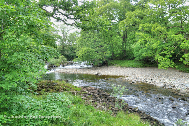
We met up with the Dales Way again by the banks of the River Rawthey at Birks Mill, a former water powered cotton mill. Here we also met up with the group of four walkers we'd previously encountered at Hubberholme and Ribblehead and we chatted to them briefly as we all puzzled over our maps in search of the correct path. For a short while it had felt as if we'd been walking in the wrong direction as the path followed a loop in the river. Once we had all been reassured by the map, we left the other four behind and strode off along the banks of the Rawthey.

The River Rawthey at Sedbergh
The path continued to follow the Rawthey to the point where it converged with the River Dee, the meeting of the two rivers just visible to us through a gap in the trees.

The meeting of the Dee and the Rawthey
A short distance beyond the merging rivers we passed under the old Rawthey Rail Bridge, which once carried the Ingleton Branch Line, a railway which had been dismantled in 1967.

The Rawthey Rail Bridge
The path continued along the banks of the Rawthey and we strode out at quite a fast pace so that we had soon left the other four walkers behind us. This was the third consecutive day we had tried to avoid them and I hope they didn't take it personally. It's just that we really do prefer to walk alone and out of earshot of others, if at all possible. I'm pretty sure the majority of long distance walkers feel the same way.
A couple of fieldside paths later and we had reached the road from Sedbergh to Kirkby Lonsdale. I turned to look back, relieved to see that the others were now nowhere in sight. We could relax our pace a little, following the road for a couple of hundred yards or so before turning into a field and heading towards the River Lune and the very beautiful Lincoln's Inn Bridge. This charming 17th century bridge, named after an inn which no longer exists, once marked the boundary between Yorkshire and the former county of Westmorland.

Lincoln's Inn Bridge
After clambering over a stile at the side of the bridge we crossed the road and walked along the edge of a delightful wildflower meadow by the side of the River Lune, the landscape undulating gently towards the distant Howgill Fells. The entire section of the Dales Way between Sedbergh and our evening's destination at Burneside was completely new to me and something of a pleasant surprise, particularly at this point, as we entered the very beautiful Lune Valley.

Wildflower meadow and the Howgill Fells
All of a sudden, it seemed, the magnificent Lune Viaduct appeared before us; a beautifully preserved piece of Victorian engineering which had once carried the Ingleton Branch Line railway over the River Lune and onwards to Tebay. As we approached we spotted a couple we had passed leaving the Spar shop that morning and we stopped to chat to them for a while, discovering that they too were heading to Burneside and the same bed and breakfast establishment as us. They were taking a break for a snack and to capture some images of the viaduct and so we left them in peace and passed under the viaduct's tall arches before climbing steeply up the bank on the other side. At the top of the hill I looked back and was rewarded with a truly splendid view of the viaduct's full span.

The Lune Viaduct
For a little way beyond the viaduct the path became indistinct and, after checking my GPS device to ensure we were still on course, I suddenly spotted a very helpful prompt, painted in white letters on the side of a tree. Clearly it would be easy to stray from the route over these lush, green pastures where there was no obvious path, and the farmer may well have got a bit fed up of people wandering about his land. We passed a few of these little improvised signs on this section and found them to be most helpful in moments of uncertainty.

A helpful tree
As we walked along the side of the Lune Valley from time to time I glanced over my shoulder. There were now at least six other Dales Way walkers behind us, but I could see no signs of their approach. Except for the occasional bleating of sheep it was blissfully peaceful. And so amazingly green! I breathed in deeply as I walked and the air was almost intoxicating.

50 Shades of Green
The path had now climbed gently above the River Lune, crossing open farmland and passing through a field of grazing cows. Sometimes walking through cattle can be a little intimidating, but these ladies were clearly more interested in the lush grass than two humans slowly tramping by. Only one of them seemed mildly curious as I paused to take a photograph. In the background the Howgill Fells looked every bit like the "sleeping elephants" they had once been likened to by Wainwright.

One curious cow
The route gradually descended again, taking us back to the banks of the Lune and a bend in the river where we paused for a few minutes, enjoying the tranquil scene and a splash about in the shallow water. Remarkably, we still had the place all to ourselves, there being no sign of any of the other walkers gaining on us, or anyone else for that matter.

The River Lune
Beyond the river bend a well defined path led us through a meadow thickly carpeted with yellow flowers - buttercups and possibly water irises (plant identification is not my strong point!).

Riverside meadow
As we left the meadow to walk through a short section of woodland a little terrier suddenly sprang out of the undergrowth by our side, barking excitedly before scurrying off to join its owner, who we could now see walking along the path ahead of us. It was clear that this old gentleman was unaware of our approach and so I started to chatter away to Tom, hoping the sound of my voice would prevent him from being startled. It didn't.
"Good morning", I said cheerily as I passed him by at which point he almost jumped out of his skin.
"I ought to be used to all you Dales Way walkers by now," he chuckled, once he'd recovered.
We walked along with the old gentleman for the rest of this short section, chatting about salmon fishing in the Lune and the problems caused by the rising population of Goosanders in the area. I had never heard of this predatory, saw-billed duck before and was fascinated to learn of the impact its increase has had on fish stocks in the area.
"Keep a look out for them when you get to the Crook of Lune Bridge," the old gentleman told us before he continued along the side of the riverbank, leaving us to follow the path steeply uphill and down again towards the bridge.
The Crook of Lune bridge was possibly the most beautiful of all the bridges we crossed along the Dales Way. Believed to be medieval in origin, it was once a packhorse or drovers' bridge, predominantly used to drive cattle southwards to market. As we paused for a few moments to take in the beauty of this place a car pulled up at our side, driven by the old gentleman we had just been chatting to.
"You can get a smashing bacon butty at a house just up the road from here," he told us. "If they're open they'll have a sign out."
We thanked him and he waved as he drove off, leaving me with a sudden craving for a crispy bacon roll.

Crook of Lune Bridge
We spent a while by the Crook of Lune Bridge, trying to see if we could identify a Goosander among the different kinds of wildfowl swimming about in the river's margins. I walked down to the water's edge and spotted a salmon fisherman in the distance, the backdrop of the Howgills creating a picture of tranquility.

Tranquil Crook of Lune
Soon we were joined by the couple we'd met up with at the Lune Viaduct and after chatting with them briefly we set off on our way again, leaving them to enjoy this beautiful place for themselves. A short section of road walking followed, passing by a decidedly Cumbrian looking stone cottage by the side of a tributary of the Lune.

Cottage by a Lune tributary
Leaving the road briefly we followed a track which passed under the impressive arches of the Lowgill Viaduct. I have read that when this viaduct was built in 1861, the Lancaster and Carlisle Railway encountered problems recruiting experienced navvies, because they apparently found the area too dull. I find that a bit hard to believe, but then I suppose there is a distinct lack of pubs in this area.

Lowgill Viaduct
Immediately after the viaduct we followed a lane uphill away from a crossroads, in search of the house offering bacon sandwiches. The old chap we'd met at Crook of Lune had said there would be a sign and, as we climbed the hill, it quickly became apparent that we were out luck. No sign and no telltale smell of frying bacon either! The view back in the direction of the viaduct and the distant Howgills was rather splendid though.

Above Lowgill
Something about our route didn't feel quite right as we continued to climb the hill away from Lowgill. Ahead of us I could hear the constant drone of traffic on the nearby M6 motorway, which I knew we had to eventually cross, and yet I was sure that at this point we should have been heading across a field in the direction of a footbridge. A quick comparison between the map and my GPS device soon revealed our error. While we had been hunting for a bacon sandwich, we should really have been looking for a footpath sign which would have pointed us in the right direction. By now we had walked for about a mile beyond the point where we should have turned. After further study of the map, however, we decided that we may as well follow the road, which would eventually meet up with the correct route anyway, just below the path to the footbridge.
As it turned out, although our unintentional diversion was a slightly longer route to the footbridge, I believe it may have been quicker, as walking along the road meant we avoided a few stiles and gates. After a mile or so we spotted a familiar Dales Way sign, pointing us across a field towards the concrete footbridge at Lambrigg Head. As we crossed over I paused to take a photo of Tom at the end of the bridge....

...who in turn was taking a photo of me at the other end...

...whilst below the traffic on the busy M6 motorway thundered by and I was very grateful for the presence of a bridge. I wouldn't fancy having to negotiate our way through that kind of traffic!

Crossing the M6
The view from the other side of the motorway was something of a stark contrast - a farmyard littered with a collection of old tyres and motorway signs beyond which, on the far horizon, we caught our first glimpse of the distant Lakeland fells. We were now much closer to the Lake District, something that always fills me with delight.

A contrasting scene
As we headed away from the cluttered farmyard the sun began to break through the cloud cover and this, combined with the view ahead of us, provided a boost to my energy levels. All of my life I have felt a compulsion to head westwards and now, with the distant mountains in view, it felt as if I was walking "home". The path we needed to follow was very well defined by the regular tramping of feet through the grass, something we nicknamed the "Dales snail trail". My guidebook had said that care with pathfinding was needed at this point because the local landowners hereabouts are not particularly walker-friendly. However, when signposts were lacking and we were in any doubt as to which direction to take, we'd simply look for the "snail trail" and it never let us down.

A clear path
A short section of our route now took us through a wonderful little area of woodland adjacent to 17th century Moresdale Hall. This wooded area was in full flower with a profusion of rhododendrons, the sunlight filtering through the trees illuminating their blooms. It was now well past our usual time for lunch and I briefly considered breaking here to eat our sandwiches in this glorious setting. It just felt a bit too much like someone's private garden though, and so we continued on our way, keeping a watch out for a suitable place to sit for a while.

Beautiful rhododendrons
After we'd left the lovely flowering woodland behind, we crossed a field to follow the trail alongside the main west coast railway line. On 23rd February 2007 there had been a major train derailment along this section of track which had sadly resulted in the death of one lady passenger and injury to 88 others . A subsequent inquiry had revealed that faulty points were to blame and consequently Network Rail had been fined a total of £4 million. Virgin Trains operate the high-speed tilting Pendolino class train along this line, and I hoped that we may see one heading to or from Scotland as we walked along in search of the ideal spot for our lunch.

The West Coast Main Line
All was peaceful though as we left the fieldside path and crossed a stile onto a lane by the side of a bridge. Here we found a place to sit, on a metal barrier by the side of a lay-by. Not the most perfect place to eat lunch, but it was a relief to rid myself of the weight of my rucksack for a short while. And the sun was still shining. As we sat, perched on the metal barrier munching our sandwiches, the couple we had already met twice that morning arrived, shortly followed by another couple of walkers we hadn't seen before. The four of them stopped on the bridge for a chat, cameras at the ready, clearly hoping to snap a shot of a passing Pendolino. I fully anticipated we would soon be seeing the party of four walkers we'd left behind at the start of the day but, it turns out, that had been the last we were to see of them for the entirety of the walk.
The two couples were still leaning over the bridge, waiting for a train, as we set off on our way again, crossing the bridge and striding purposefully along the lane in the direction of Grayrigg. I expected to see them following us before long, and when they didn't I began to have a moment of doubt. We'd walked along the lane for about half a mile or so before I realised that we should have turned into a field directly on the other side of the bridge. By the time we got back to the bridge the others had left, much to my relief. The path was clearly marked at this point and I felt very foolish for having missed it.
Ahead of us stretched the now familiar "snail trail", leading us through rich pastureland with grazing cattle. In the distance the Lakeland fells continued to beckon us onwards.

Back on the right path
It was now mid afternoon and, by my calculations, we had just over five miles left to walk to our evening's destination at Burneside. At our current, fairly slow, speed this would mean we should arrive a little after 5 p.m. We had walked just over 11 miles and, in spite of our recent break, I was beginning to tire a little. This day's section of the Dales Way had included considerably more stiles than the rest of the walk and I believe the cumulative effect of all that clambering up and down had contributed to my waning energy levels. Just when I needed it most, however, a very thoughtful local farmer had left a makeshift tuck shop by the side of his farmhouse wall, complete with honesty box. I love Kendal Mint Cake and the timing of its unexpected availability was perfect!

Impromptu Tuck Shop
As the Dales Way continued to cross farmland I wondered if this area was a continuation of that mentioned in the guidebook, where the local landowners are not particularly walker-friendly. There was a noticeable lack of direction signs, and once again we were thankful for the "snail trail", showing us that we were still on the right track.

The Dales Snail Trail
We left the fields for a while to walk along an access road past a beautiful colonial style mansion house, looking very grand indeed in the afternoon sunshine with a backdrop of the fells beyond.

I'd quite like to live here!
Turning off the access road the route now took us through what looked like someone's personal driveway and garden. I paused for a while, feeling hesitant about entering, and checked both my map and GPS before doing so. It was very pretty indeed, but if definitely felt like we were trespassing at this point.

This surely must be someone's garden
The path through the garden climbed steadily uphill and at the top I got the distinct impression we were about to pay the price for our unavoidable intrusion. The way ahead, whilst clearly marked as a footpath by virtue of a yellow arrow, was obstructed by a metal gate beyond which there lay a path dense with waist-high undergrowth, which appeared to be predominantly nettles. We were both wearing shorts. Once again I checked my map and GPS. This was definitely the way and, as far as I could tell, there was just a very short section of this path which would lead us out onto a road. There was no way round it. Taking a deep breath I clambered over the gate and ran for it, thrashing my way as best I could with the aid of my walking poles. I only got a couple of stings, which was remarkable given the density of the nettles. In a strange, masochistic way, it was kind of refreshing and once on the road I found that I had tapped into an extra reserve of energy.

From the sublime to the ridiculous
Having crossed another couple of fields we eventually reached the lovely little Black Moss Tarn which, as my guidebook correctly pointed out, is more of a hill pond than an actual tarn, given that it isn't located on a mountain. Nevertheless, it was a very picturesque place and I quickly forgot about my smarting nettle stings.

Black Moss Tarn
We were getting ever closer to Burneside now and a short section of road walking confirmed this as we looked down upon the town of Kendal, nestling in the valley below. Originally I had booked our evening's accommodation in Kendal, until I had discovered that the Dales Way doesn't actually pass through the town but instead skirts around it to the east. Fortunately I had been able to cancel my original booking without incurring a charge and was lucky enough to secure a room at the very popular Lakeland Hills Bed and Breakfast in Burneside. As I was soon to discover, this turned out to be a very good move indeed.

Above Kendal
We continued to follow the lane until it reached a junction with the A6 which we crossed and then followed the path which meandered over several fields before reaching the River Sprint and the charming Sprint Mill. This historic watermill was built in 1840 and today offers educational visits centred around the history of the mill, rural crafts and wildlife.

Sprint Mill
The final section of our walk into Burneside briefly entailed a section of walking alongside a narrow and very busy road. Thankfully a new path had recently been opened towards the end of this stretch and we were very grateful for it.
We were equally grateful to find a very warm welcome awaiting us at our evening's accommodation. The Lakeland Hills is owned by Tony and Caroline Hill and is advertised as being "run by walkers for walkers". Our stay there was absolutely wonderful! Tony, it turns out, is a former Lake District National Park Warden, an experienced mountaineer and all-round outdoors enthusiast. Our room, which was spacious, comfortable and extremely well-equipped also had its very own little honesty box tuck shop within the wardrobe. I was delighted to find several bottles of Wainwright ale in there and, having enjoyed a wonderfully powerful, hot shower, I helped myself to a couple of bottles. Evening meals aren't provided at the Lakeland Hills, but Tony very kindly drove us and the other couple (the pair we had met several times during the course of the day) out to a local pub and restaurant where we spent a highly enjoyable evening in their company. In spite of all my tactics to avoid having to walk in close proximity to others, I am actually quite a sociable person really. Honest!
Total distance walked: 16.5 miles
Total walking time: 8 hours 5 minutes (including several short breaks)
Next time...All too quickly our last day on the Dales Way was upon us. Leaving Burneside behind we had the relatively short distance of just over ten miles to take us to the finishing point at Bowness-on-Windermere.


Comments
Post a Comment