Spring in Farndale and Rosedale (North York Moors)
Spring had definitely sprung when we headed out once again into the North York Moors National Park for a superb circular walk of 12 miles which was to include daffodils, lambs and blossom in abundance. Everything you would associate with this, the most wonderful of seasons, including plenty of blue sky and warm sunshine. And, as if that wasn't enough springtime imagery for one walk, it was also Good Friday and I'd started the day with a breakfast of toasted hot cross buns!
Our walk began in the moorland valley of Farndale which is famous for its daffodils.
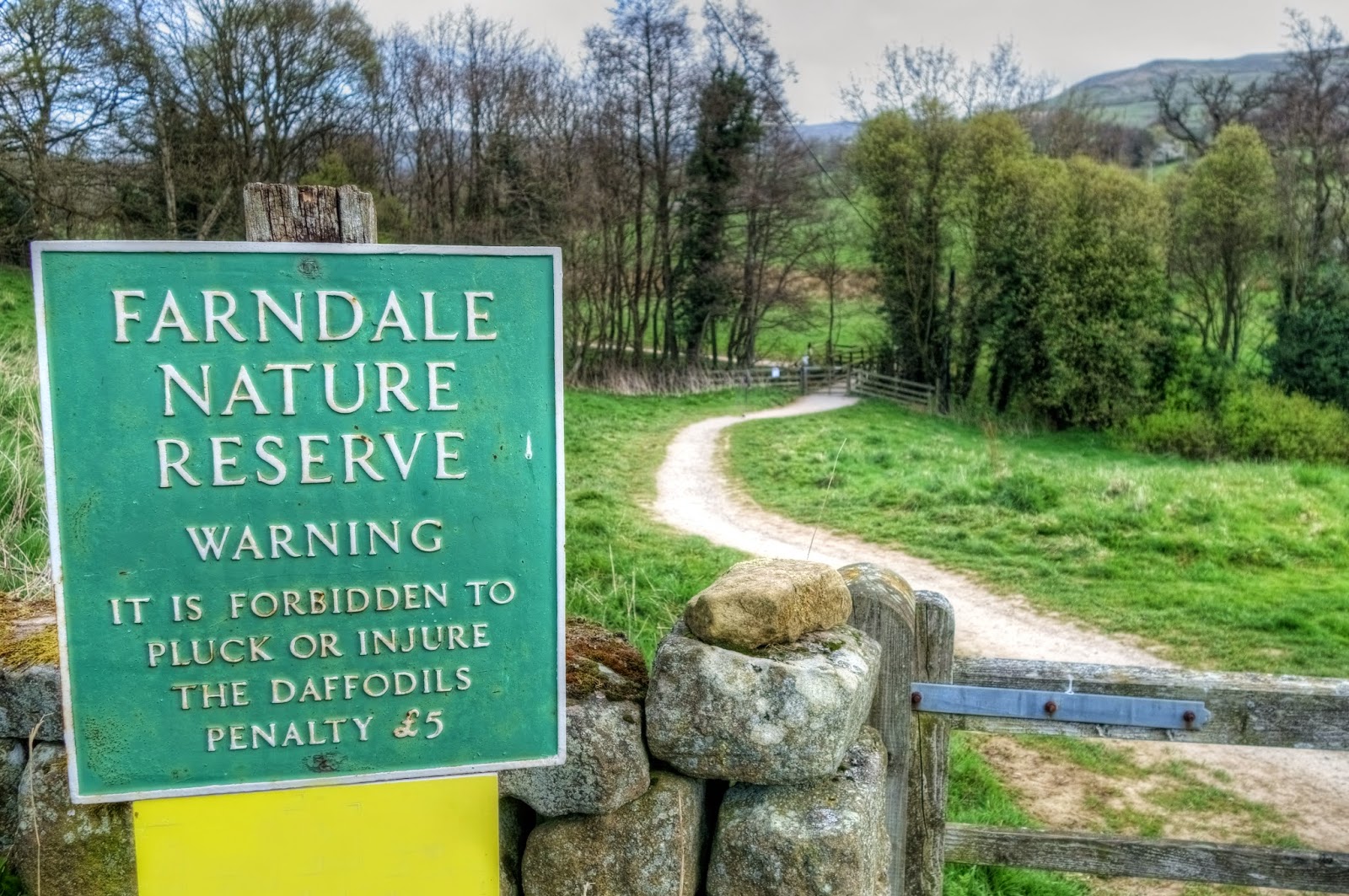
The Farndale Nature Reserve was created in 1955 to safeguard these flowers which, contrary to popular belief, were not planted by monks from nearby Rievaulx Abbey but are actually native wild flowers (Narcissus pseudonarcissus). Smaller and more delicate than the domestic daffodils we grow in our gardens, their preferred habitat is shaded woodland, grassland or riverbanks and the beautiful valley of Farndale provides all of these conditions perfectly. Usually the best time to visit is between mid-March and mid-April, depending on the preceding weather conditions. I had hoped to have visited a little sooner, and there's no doubt that the blooms had passed their best by Easter, but even so there were still plenty of flowers to see.


We had been warned that in spring the valley can be very crowded with visitors (up to 40,000 people usually visit during the short flowering season) and parking can be a problem. So, with that in mind, we left home at the crack of dawn and arrived at the little hamlet of Low Mill just before 8 a.m. to find an empty car park and not another soul in sight. As we set off to walk along the banks of the River Dove all we could hear was birdsong and the bleating of new-born lambs. It was glorious.

The first part of our walk followed the course of the River Dove as it meanders through the nature reserve in the direction of Church Houses. This section of the walk is mostly on the level and very well paved thanks to the efforts of the National Park Authority and local landowners who work very hard to ensure that visitors can stick to defined routes without disturbing the habitat and thus the impact on the environment is kept to a minimum.

As we drew nearer to Church Houses a sign on a gate caught our attention. "You are only three fields from the Daffy Caffy" it announced and then further taunted us by asking "Can you smell the bacon?" Although we couldn't yet smell any bacon, it had been a good while since those toasted hot cross buns and the thought of a coffee and bacon sandwich to fuel us for the rest of the walk was very appealing indeed.

The next three fields passed by at a little quicker pace and before long we approached High Mill, home of the Daffy Cafe, where we soon realised just why we hadn't been able to smell the bacon. The cafe was closed. Or to be correct, it had yet to open. In our eagerness to get there we had arrived 20 minutes before the 9 a.m. opening time.

There's one aspect of this walk which I have so far failed to mention. And that is the fact that, apart from walking through Farndale's daffodil reserve, I really had no idea how long our walk was going to be or in what direction we would be heading next. I had decided, for the first time ever, to make it up as we went along. So, although I wasn't sure which way to go next as we disappointedly peered at the closed doors of the Daffy Cafe, I certainly didn't feel like hanging around for 20 minutes for a bacon sandwich. That said, the thought of a hot drink and a bite to eat at some point along the walk was still appealing and it was this thought which determined the direction in which we headed next. Almost a year ago we had discovered Dale Head Farm in Rosedale, where teas, coffees and delicious sandwiches and cakes are served in the garden of a typical moorland farmhouse. I had wanted to go back and sample some more of their tasty treats and a quick look at my map revealed that this would entail a walk of only a couple of miles or so from our current position. The next stage of our walk was fixed and we set off in an easterly direction, heading out of the hamlet of Church Houses and following the quiet country road in the direction of Blakey Ridge. This entailed a steep and steady climb up Blakey Bank, a 1 in 5 gradient (20%) with increasingly stunning views of Farndale and High Blakey Moor.

At the top of Blakey Ridge we crossed the main road and paused for a while to look down upon Rosedale. Here we crossed the line of the former Rosedale Railway where an information panel informed us this point was Blakey Junction.

Magnetic ironstone was discovered in Rosedale in 1853 and by 1856 open cast mining in the area was producing ironstone of a very high quality, leading to the commencement of drift mining and eventually full production at the Rosedale West Mine in 1861. Thereafter a further mine was opened at Rosedale East in 1864. The Rosedale Railway was a remarkable feat of Victorian engineering which transported ironstone across the moorland to the main line at Battersby Junction from where it could be carried onwards. Today the abandoned railway track provides an excellent level route for walkers and cyclists as it winds its way around the top of the valley for over ten miles in total. There are various ruins and reminders of mining activities dotted around the edges of Rosedale and the information panel provided a panoramic key to just a few of these sites of interest.

Looking down and across the valley we could see our next destination of Dale Head Farm and we strode off purposefully down the hill.

Once in the valley bottom we followed a quiet country lane where occasional little signs attached to fence posts confirmed we were heading in the right direction. By this time I was beginning to feel more than a little bit peckish as I recalled the delicious Wensleydale cheese and chutney sandwich I had enjoyed on our last visit, which had been followed by a large chunk of thickly buttered fruit loaf.

By the time we reached the farmhouse I was positively famished, even though it was only 10 a.m. Sadly though, not one of those little advertising signs had mentioned the opening times for Dale Head Tea Garden which, we now discovered, didn't open until 11 a.m. After muttering something curmudgeonly and unrepeatable about the lack of enterprise displayed by the local eateries, I consulted my map again, unsure of what direction we would take next. All these unfulfilled offers of food meant that refreshment was now a priority and that left us only two choices - a climb back up onto Blakey Ridge to the Lion Inn or a walk along the valley bottom to the village of Rosedale Abbey. As it presented the best option for a circular route, we chose the latter and retraced our steps for a short distance to a farm called Hollin Bush where we could join a track known as Daleside Road which would take us to the hamlet of Thorgill.

To begin with Daleside Road is simply a grassy track, occasionally muddy in places, which leads through a series of fields until eventually, as it approaches Thorgill, it becomes a surfaced country lane. Walking along here in the spring sunshine was an absolute delight as we passed several fields with new-born lambs, hedgerows bursting with hawthorn blossom and patches of wild primroses by the wayside. For the first three miles of this four mile stretch of the walk to Rosedale we only saw two other walkers. It was wonderfully tranquil.


From Thorgill our route took us over a field which led to a farmyard after which we crossed a river and then followed its course down into the village of Rosedale Abbey. The name of this charming moorland village is a little confusing as today all that remains of the Cistercian nunnery which gave the village its name is the ruin of a small turret staircase next to the church of St Mary and St Laurence. The church was built in 1839 from stones remaining from the former abbey.

It was a relief to find that the Abbey Tea Rooms were open and, surprisingly given that it was now approaching midday, not at all busy. Strictly speaking it was only just lunchtime, but in spite of this we ordered an afternoon tea of sandwiches and cakes which was very welcome indeed. And totally delicious too. Perhaps more so given our two earlier failed attempts to find refreshment.

Over my second cup of coffee and slice of cake I consulted the map and realised that we had now walked eight miles, leaving a further four miles back to our car at the Low Mill car park. This entailed what appeared to be a steady climb back up to the disused railway track, over the top of Blakey Ridge again and back down into Farndale. Suitably refreshed we set off back in the direction of Thorgill where we took an uphill footpath over the top. Pausing for a rest halfway up the ridge we were rewarded with a stunning view of Rosedale.

Once back on the old railway line we realised we had wandered slightly off course. This often happens on the moors I find, where the pathways aren't always very clear and spotting the right line through the heather can be problematic.

On my map (OS 1:25 000) I could see the familiar green dashes marking out a path to the main road across Blakey Ridge but finding it proved to be something of a challenge. Eventually, after much squinting at the map and scratching of heads we struck off in what looked like the right direction and were eventually rewarded with a clearly defined track. The GPS hadn't been much help and, not for the first time, I promised myself I simply must brush up on my compass and map reading skills.

From the main road the route back to Low Mill was obvious and as we headed downhill we could see the car park which appeared to be full to capacity.

The views of Farndale were stunning and by now there was hardly a cloud in the sky.

Once away from the moorland and back in the fertile green valley bottom we once again encountered daffodils growing by gateways and drystone walls. These, however, weren't the wild variety but the more common, larger flowers usually found in gardens.

The Easter holiday sunshine combined with the approaching end to the flowering season had attracted a great number of visitors and the tiny hamlet of Low Mill was teeming with cars and people. After the peace and solitude we'd enjoyed during our walk this abrupt return to civilisation was too much of a shock to the system. Clearly we had made the right decision in starting the walk as early in the day as possible and I can certainly recommend this tactic to anyone wishing to follow in our footsteps. The daffodils will all have gone by now but even without the sight of their pretty little yellow heads bobbing in the breeze, Farndale is still a truly beautiful place.

Directions for this walk:
Leaving from the car park at Low Mill follow the well defined path through the Nature Reserve which follows the course of the River Dove to High Mill and then along the lane to the small village of Church Houses. After passing the Feversham Arms public house turn left onto Long Lane and follow this quiet country road steeply up Blakey Bank to the main road at the top.
After crossing the main road look for the information panel for Blakey Junction behind which a path leads downhill into Rosedale. Here you can either take a short detour to visit Dale Head (provided it's open of course!) or turn onto Daleside Road which is down the lane just after a group of farm buildings.
Follow Daleside Road all the way to Thorgill and shortly after entering the hamlet a path on the left leads over a field, across a bridge and passes a farmyard to your right. After passing the farm there's a stile to cross after which turn right and follow the path down into Rosedale Abbey. The path into the village passes through a caravan site until a sign directs you to turn left to emerge in the village opposite the little church.
After visiting the village retrace your steps back into the caravan site opposite the church but this time keep straight on until you reach the river. At the riverbank turn right and carry on until you reach a footbridge, then cross a field and turn right, following the road to Thorgill until a footpath on the left takes you across fields to the hamlet where a path to the left heads up Thorgill Bank. At the top of the bank you need to find a path over the moor and back to the main road. The easiest one to find is just before an abandoned mining shaft which is visible on the horizon if you follow the old railway track. This will then necessitate turning left on the main road until you can find the footpath back down into Farndale. There are a couple of these and the easiest route is to find the one which leads directly to Farndale (as shown on the map). From here it's just a straightforward downhill back to the car park.

Coming soon...
Two wonderful walks in the Cleveland Hills and Bilsdale. Be sure to follow me on Facebook for regular updates.
Our walk began in the moorland valley of Farndale which is famous for its daffodils.
The entrance to Farndale Daffodil Reserve
The Farndale Nature Reserve was created in 1955 to safeguard these flowers which, contrary to popular belief, were not planted by monks from nearby Rievaulx Abbey but are actually native wild flowers (Narcissus pseudonarcissus). Smaller and more delicate than the domestic daffodils we grow in our gardens, their preferred habitat is shaded woodland, grassland or riverbanks and the beautiful valley of Farndale provides all of these conditions perfectly. Usually the best time to visit is between mid-March and mid-April, depending on the preceding weather conditions. I had hoped to have visited a little sooner, and there's no doubt that the blooms had passed their best by Easter, but even so there were still plenty of flowers to see.
Beautiful Farndale
Wild Daffodils (Narcissus pseudonarcissus)
We had been warned that in spring the valley can be very crowded with visitors (up to 40,000 people usually visit during the short flowering season) and parking can be a problem. So, with that in mind, we left home at the crack of dawn and arrived at the little hamlet of Low Mill just before 8 a.m. to find an empty car park and not another soul in sight. As we set off to walk along the banks of the River Dove all we could hear was birdsong and the bleating of new-born lambs. It was glorious.
A Farndale lamb
The first part of our walk followed the course of the River Dove as it meanders through the nature reserve in the direction of Church Houses. This section of the walk is mostly on the level and very well paved thanks to the efforts of the National Park Authority and local landowners who work very hard to ensure that visitors can stick to defined routes without disturbing the habitat and thus the impact on the environment is kept to a minimum.
Path through Farndale
As we drew nearer to Church Houses a sign on a gate caught our attention. "You are only three fields from the Daffy Caffy" it announced and then further taunted us by asking "Can you smell the bacon?" Although we couldn't yet smell any bacon, it had been a good while since those toasted hot cross buns and the thought of a coffee and bacon sandwich to fuel us for the rest of the walk was very appealing indeed.
Can you smell the bacon yet?
The next three fields passed by at a little quicker pace and before long we approached High Mill, home of the Daffy Cafe, where we soon realised just why we hadn't been able to smell the bacon. The cafe was closed. Or to be correct, it had yet to open. In our eagerness to get there we had arrived 20 minutes before the 9 a.m. opening time.
Approaching the Daffy Caffy...still no smell of bacon
There's one aspect of this walk which I have so far failed to mention. And that is the fact that, apart from walking through Farndale's daffodil reserve, I really had no idea how long our walk was going to be or in what direction we would be heading next. I had decided, for the first time ever, to make it up as we went along. So, although I wasn't sure which way to go next as we disappointedly peered at the closed doors of the Daffy Cafe, I certainly didn't feel like hanging around for 20 minutes for a bacon sandwich. That said, the thought of a hot drink and a bite to eat at some point along the walk was still appealing and it was this thought which determined the direction in which we headed next. Almost a year ago we had discovered Dale Head Farm in Rosedale, where teas, coffees and delicious sandwiches and cakes are served in the garden of a typical moorland farmhouse. I had wanted to go back and sample some more of their tasty treats and a quick look at my map revealed that this would entail a walk of only a couple of miles or so from our current position. The next stage of our walk was fixed and we set off in an easterly direction, heading out of the hamlet of Church Houses and following the quiet country road in the direction of Blakey Ridge. This entailed a steep and steady climb up Blakey Bank, a 1 in 5 gradient (20%) with increasingly stunning views of Farndale and High Blakey Moor.
Looking down into Farndale from Blakey Bank
At the top of Blakey Ridge we crossed the main road and paused for a while to look down upon Rosedale. Here we crossed the line of the former Rosedale Railway where an information panel informed us this point was Blakey Junction.
Blakey Junction information panel
Magnetic ironstone was discovered in Rosedale in 1853 and by 1856 open cast mining in the area was producing ironstone of a very high quality, leading to the commencement of drift mining and eventually full production at the Rosedale West Mine in 1861. Thereafter a further mine was opened at Rosedale East in 1864. The Rosedale Railway was a remarkable feat of Victorian engineering which transported ironstone across the moorland to the main line at Battersby Junction from where it could be carried onwards. Today the abandoned railway track provides an excellent level route for walkers and cyclists as it winds its way around the top of the valley for over ten miles in total. There are various ruins and reminders of mining activities dotted around the edges of Rosedale and the information panel provided a panoramic key to just a few of these sites of interest.
Rosedale's disused railway track
Looking down and across the valley we could see our next destination of Dale Head Farm and we strode off purposefully down the hill.
Looking down towards Dale Head (the farm in the middle distance)
Once in the valley bottom we followed a quiet country lane where occasional little signs attached to fence posts confirmed we were heading in the right direction. By this time I was beginning to feel more than a little bit peckish as I recalled the delicious Wensleydale cheese and chutney sandwich I had enjoyed on our last visit, which had been followed by a large chunk of thickly buttered fruit loaf.
This way to the tea garden
By the time we reached the farmhouse I was positively famished, even though it was only 10 a.m. Sadly though, not one of those little advertising signs had mentioned the opening times for Dale Head Tea Garden which, we now discovered, didn't open until 11 a.m. After muttering something curmudgeonly and unrepeatable about the lack of enterprise displayed by the local eateries, I consulted my map again, unsure of what direction we would take next. All these unfulfilled offers of food meant that refreshment was now a priority and that left us only two choices - a climb back up onto Blakey Ridge to the Lion Inn or a walk along the valley bottom to the village of Rosedale Abbey. As it presented the best option for a circular route, we chose the latter and retraced our steps for a short distance to a farm called Hollin Bush where we could join a track known as Daleside Road which would take us to the hamlet of Thorgill.
Daleside Road
To begin with Daleside Road is simply a grassy track, occasionally muddy in places, which leads through a series of fields until eventually, as it approaches Thorgill, it becomes a surfaced country lane. Walking along here in the spring sunshine was an absolute delight as we passed several fields with new-born lambs, hedgerows bursting with hawthorn blossom and patches of wild primroses by the wayside. For the first three miles of this four mile stretch of the walk to Rosedale we only saw two other walkers. It was wonderfully tranquil.
Blossom lined lane
Wild primroses in the hedgerow
From Thorgill our route took us over a field which led to a farmyard after which we crossed a river and then followed its course down into the village of Rosedale Abbey. The name of this charming moorland village is a little confusing as today all that remains of the Cistercian nunnery which gave the village its name is the ruin of a small turret staircase next to the church of St Mary and St Laurence. The church was built in 1839 from stones remaining from the former abbey.
The Church of St Mary & St Laurence, Rosedale Abbey
It was a relief to find that the Abbey Tea Rooms were open and, surprisingly given that it was now approaching midday, not at all busy. Strictly speaking it was only just lunchtime, but in spite of this we ordered an afternoon tea of sandwiches and cakes which was very welcome indeed. And totally delicious too. Perhaps more so given our two earlier failed attempts to find refreshment.
Rosedale Abbey Tea Rooms (refreshment at last!)
Over my second cup of coffee and slice of cake I consulted the map and realised that we had now walked eight miles, leaving a further four miles back to our car at the Low Mill car park. This entailed what appeared to be a steady climb back up to the disused railway track, over the top of Blakey Ridge again and back down into Farndale. Suitably refreshed we set off back in the direction of Thorgill where we took an uphill footpath over the top. Pausing for a rest halfway up the ridge we were rewarded with a stunning view of Rosedale.
Looking down into Rosedale from Thorgill Bank
Once back on the old railway line we realised we had wandered slightly off course. This often happens on the moors I find, where the pathways aren't always very clear and spotting the right line through the heather can be problematic.
Where's the path?
On my map (OS 1:25 000) I could see the familiar green dashes marking out a path to the main road across Blakey Ridge but finding it proved to be something of a challenge. Eventually, after much squinting at the map and scratching of heads we struck off in what looked like the right direction and were eventually rewarded with a clearly defined track. The GPS hadn't been much help and, not for the first time, I promised myself I simply must brush up on my compass and map reading skills.
The path back to Blakey Ridge
From the main road the route back to Low Mill was obvious and as we headed downhill we could see the car park which appeared to be full to capacity.
Downhill back into Farndale
The views of Farndale were stunning and by now there was hardly a cloud in the sky.
Looking down into Farndale
Once away from the moorland and back in the fertile green valley bottom we once again encountered daffodils growing by gateways and drystone walls. These, however, weren't the wild variety but the more common, larger flowers usually found in gardens.
More daffodils
The Easter holiday sunshine combined with the approaching end to the flowering season had attracted a great number of visitors and the tiny hamlet of Low Mill was teeming with cars and people. After the peace and solitude we'd enjoyed during our walk this abrupt return to civilisation was too much of a shock to the system. Clearly we had made the right decision in starting the walk as early in the day as possible and I can certainly recommend this tactic to anyone wishing to follow in our footsteps. The daffodils will all have gone by now but even without the sight of their pretty little yellow heads bobbing in the breeze, Farndale is still a truly beautiful place.
Directions for this walk:
Leaving from the car park at Low Mill follow the well defined path through the Nature Reserve which follows the course of the River Dove to High Mill and then along the lane to the small village of Church Houses. After passing the Feversham Arms public house turn left onto Long Lane and follow this quiet country road steeply up Blakey Bank to the main road at the top.
After crossing the main road look for the information panel for Blakey Junction behind which a path leads downhill into Rosedale. Here you can either take a short detour to visit Dale Head (provided it's open of course!) or turn onto Daleside Road which is down the lane just after a group of farm buildings.
Follow Daleside Road all the way to Thorgill and shortly after entering the hamlet a path on the left leads over a field, across a bridge and passes a farmyard to your right. After passing the farm there's a stile to cross after which turn right and follow the path down into Rosedale Abbey. The path into the village passes through a caravan site until a sign directs you to turn left to emerge in the village opposite the little church.
After visiting the village retrace your steps back into the caravan site opposite the church but this time keep straight on until you reach the river. At the riverbank turn right and carry on until you reach a footbridge, then cross a field and turn right, following the road to Thorgill until a footpath on the left takes you across fields to the hamlet where a path to the left heads up Thorgill Bank. At the top of the bank you need to find a path over the moor and back to the main road. The easiest one to find is just before an abandoned mining shaft which is visible on the horizon if you follow the old railway track. This will then necessitate turning left on the main road until you can find the footpath back down into Farndale. There are a couple of these and the easiest route is to find the one which leads directly to Farndale (as shown on the map). From here it's just a straightforward downhill back to the car park.
Coming soon...
Two wonderful walks in the Cleveland Hills and Bilsdale. Be sure to follow me on Facebook for regular updates.


Comments
Post a Comment