Blencathra (Lake District)
Blencathra stands like a gatekeeper to the Northern Lake District. At 2,847 feet (868 metres) it's the first mountain you encounter when driving towards Keswick from Penrith. I can't properly explain why, but the first sight of this mountain always brings a tear to my eye and a lump to my throat. There's just something about being surrounded by mountains that feels like "home" to me, and no matter how long it has been since my last visit, as I drive along the A66, Blencathra seems to be calling out to me... "Welcome Home".
This was partly why, at the start of a week's holiday in Keswick, I decided that our first climb would be Blencathra. Also, I now feel as if I have just a hint of a vested interest in this beautiful mountain. Earlier in the year the current owner of Blencathra, Lord Lonsdale, announced that he was putting the mountain up for sale to raise funds towards a large tax bill for death duties. Almost immediately the Friends of Blencathra was formed with the aim of purchasing the mountain for the people and, at the same time, to register it as a community asset. I pondered for a while as to whether I should donate to this project. After all, the mountain, like the Lake District as a whole, is so well protected with legislation, nothing should change with regard to conservation, land usage and access by the public. But then, I reasoned, why not? Why not become a part of a community dedicated to such a beautiful mountain? No one can truly know what the future holds, so why not contribute? And so I did. I made a donation, purchased a promotional hooded top and in doing so became one of the Friends of Blencathra. Now, as one of the mountain's little friends (a Blencathran, if you will), it was time for me to really get to know her.
We arrived in Keswick on a rather overcast Saturday morning and spent the day browsing around the town centre and lakeside area until the time came to collect the keys for our holiday rental - a fourth floor apartment with stunning views, sweeping round from Walla Crag, across to Catbells, Grisedale Pike and then, the main feature, an almost uninterrupted view of Skiddaw. Later that evening I sat out on our balcony to study Wainwright's Pictorial Guide to the Northern Fells, searching for the best route for Blencathra. I had hoped to be able to walk from Keswick, climb the mountain and walk back, although having checked my OS map I decided this was perhaps just a little too ambitious. I really wasn't sure which route to take, although I was adamant that I would not be including Sharp Edge, a hazardous scramble which Wainwright described as "sharp enough for shaving".
Still undecided, I tentatively posted a question on the Walker's Forum Facebook page: Was it possible to walk to Blencathra from Keswick, climb the mountain (avoiding Sharp Edge) and then walk back? Almost immediately I received a very helpful reply recommending that we catch a bus from Keswick to the hamlet of Scales at the foot of Blencathra, from which point we could ascend via Scales Fell, traverse the mountain to descend via Blease Fell to the Blencathra Centre, from where we could pick up a path back to Keswick. This turned out to be excellent advice and, after a quick check through the local bus timetables, I discovered that a bus departed from Keswick at 8.25 the next morning. Perfect!
I awoke very early the next day and immediately threw open the curtains to reveal a cloudless Skiddaw, softly side-lit with early morning light. The sun was shining as we walked through an unusually quiet Keswick town centre on our way to the bus station. Although Scales wasn't listed as a bus stop in the timetable, the driver assured me he would stop there for us and so we sat back to enjoy the short journey from Keswick which took just over ten minutes.
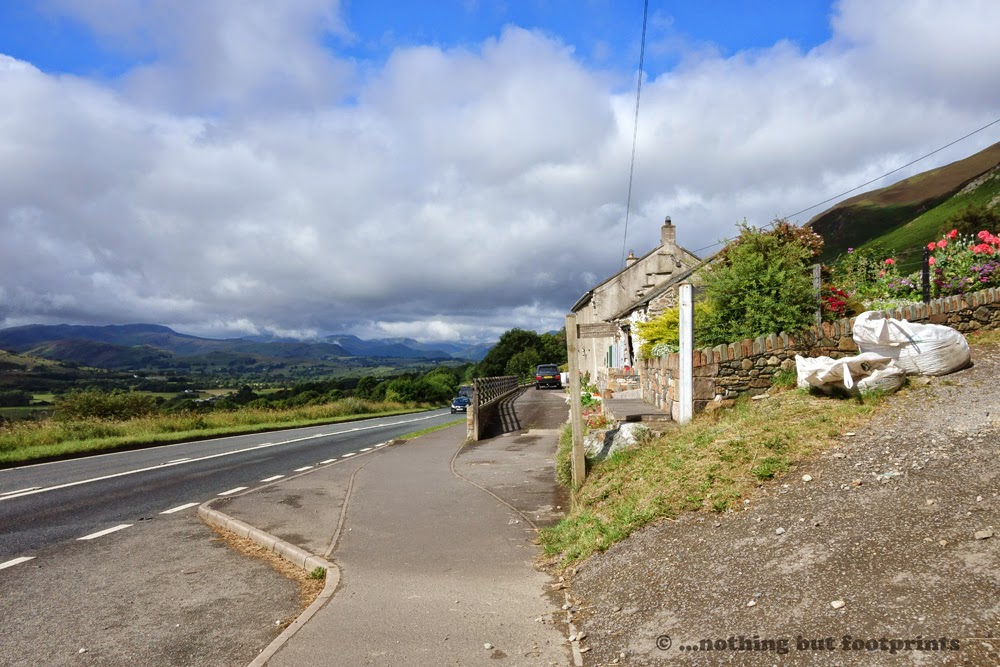
The bus dropped us by the White Horse Inn in the little settlement of Scales, which is right by the side of the busy A66. From the bus stop we walked back a couple of hundred yards along the side of the road until we located a public footpath sign directing us uphill by the side of a cottage garden. The sky was blue but there were low clouds stacking up over the fells in the west beyond Keswick. Above us though, Blencathra appeared to be bathed in sunlight - at least for the time being.
Our chosen path climbed quite gently to begin with as it ascended through the bracken, skirting the edge of Scales Fell. After a short distance I turned to look back and the clouds seemed to be heading our way, hanging low over the fells beyond the village of Threlkeld in the valley bottom.

We left the main path as it bent around the contours of Scales Fell and took a subsidiary path which climbed at a steeper gradient. The main path was heading towards Sharp Edge and, as I wished to avoid this route, we followed an alternative, lesser defined path which would take us to the edge of Doddick Fell. Before turning towards the summit I paused to admire the view across to Great Mell Fell standing in isolation with the distant Pennines on the hazy horizon.

Below the countryside appeared shrunken, like a miniature landscape just waiting for a model train to pass through. To the south I could see the Mosedale Viaduct and I half expected to see an old locomotive, gathering steam as it approached. But today the Penrith to Keswick line is deserted, having been closed in 1972. Like many dismantled railways it is now used as a public footpath and cycle track, although there are proposals to have the line re-opened in the future. For this reason a proposal to have the viaduct demolished was rejected in 1997.

The ascent was very straightforward and relatively easy, although I made frequent stops, ostensibly to take photographs with the added advantage that such pauses enabled me to catch my breath. It didn't seem to take us long though before the summit was in sight.

So far all the best views had been to the east and south east, but then suddenly, as we skirted the crest of Doddick Fell, we were treated to a breathtaking view over Threlkeld Common and beyond to the western fells, with just a glimpse of Derwent Water. The cloud cover had lifted slightly and I stood in wonder for several minutes, just drinking it all in.

The views to the east were diminishing now, obscured by the flanks of the rolling fells, and the clouds to the east were thickening over the Pennines.
 The path continued to be well defined and easy to follow as it snaked its way progressively upwards. Unlike many Lakeland mountain paths, this one was evenly surfaced, very pleasant to walk along and its meandering line meant there were no seriously steep gradients to negotiate. In short, it was a highly pleasurable walk which could be completed with ease by anyone with a reasonable level of fitness.

The gentle nature of this path may elicit the question why Wainwright described Blencathra as a "mountaineer's mountain". This can be answered in two ominous words. Sharp Edge. This knife-like ridge of rock has been described in guide books as "the most difficult obstacle on any walker's path in the Lake District". It is a route only to be tackled by those experienced at scrambling and one to be avoided on wet or windy days. From 1947 to March 2014 the Keswick Mountain Rescue Service has recorded 85 incidents on Sharp Edge, 11 of which resulted in fatalities. Many climbers simply become what's known as "cragfast", which is to say stuck, or possibly frozen with terror, part way along the ridge. For the confident scrambler and those who are not of a nervous disposition, however, Sharp Edge is said to provide one of the best experiences in Lakeland fell-walking. As for me, I'm not an adrenaline junkie, and I'm certainly not exactly confident in my mountaineering abilities. I simply want to climb mountains for the satisfaction of having got to the top, to enjoy the views (when the weather permits) and in doing so to improve my fitness. That may change with time, but right now I would rather leave Sharp Edge to others and simply admire it from afar. And with the very pretty Scales Tarn filling the corrie below, it certainly makes for a lovely mountain scene.

I could have spent many hours, sitting overlooking Scales Tarn and Sharp Edge, capturing the varying moods created by the ever-changing light. But the summit beckoned and we pressed on, pausing to watch those brave enough to traverse the knife-edge. From a higher vantage point the Sharp Edge arête didn't look quite so menacing and Tom was all in favour of descending to the tarn and tackling the scramble. After peering through the binoculars at one walker wobbling his way precariously over the rocky ridge, however, I was relieved that I was able to talk Tom out of it. If he'd gone, I would have followed, as much as I know that I would have disliked it. In the event, we plodded on with our original intended course to the top.

As we approached the summit the clouds in the west seemed to descend. Or possibly we had climbed above them. Even though we were at this point denied a sweeping panorama of the mountains to the west, we nevertheless had a wonderful view across to Derwent Water, with a hint of Thirlmere emerging beyond the valley known as St John's in the Vale.

On maps the summit of Blencathra is marked as Hallsfell Top. Unlike most Lakeland fells, the true summit is not marked with a cairn but instead there's a circular stone Ordnance Survey triangulation station. I rather liked this. It made a change from a heap of rocks or the usual concrete obelisk used for trig points.

From this vantage point we could see a little more of Thirlmere but a little less of Derwent Water and nothing at all of the western fells as the clouds began to roll in.

As I stood admiring the view Tom took a quick photo of me with his phone. It may be grainy and blurry, but it's just me and Blencathra, and for this reason this particular image is now a personal favourite.

Blencathra's alternative name is Saddleback, due to the mountain's distinctive shape, and the route to our descent via Blease Fell entailed a traverse of the "saddle". This section of the walk was a sheer joy. The sun was managing to filter through the lowering clouds and to the north we had a sweeping view across to the Skiddaw massif. It was glorious and, almost without thinking, I found myself singing, skipping and dancing along. It was a feeling of sheer euphoria; of being alive in the moment without another single thought in my mind. Fortunately , and unusually, we were the only people up there at this point, but if there had been others it wouldn't have made any difference. In more than one sense, I was experiencing a high. It was, quite simply, fantastic - which is probably why I kept on signing, over and over, "Fantastica...." (the tune from a recent World Cup themed advert)!

Our route back down via Blease Fell was as straightforward as our ascent had been. It was steep in places, but not so steep as to cause any problems. A short way down we passed an older couple with whom we exchanged greetings as they plodded their way upwards. To our astonishment, just a short time later, the same couple came bounding back down the mountain at quite a speed, eschewing the stony path in favour of a direct ascent down the steepest part, thrashing through the bracken. I have the greatest admiration for fell runners and could only stand in awe as they hurtled downhill and disappeared from sight. What strength they must have in their knees!
As we descended below the clouds we caught our first sight of Keswick, peering out from beyond the tree-lined slopes of Latrigg. As I paused to photograph the scene, another couple ascended towards us. I immediately spotted a Friends of Blencathra t-shirt and spent a happy few minutes chatting to the couple about t-shirts, the pending purchase and the mountain in general. At the time of writing the negotiations over the sale of the mountain are still ongoing, but I'm very hopeful for a favourable outcome for the "Friends" and for Blencathra.

The gradient gradually decreased as we descended the lower slopes of Blease Fell and the cloud now robbed the landscape of light. Below we could hear as well as see the busy A66 as we tried, with difficulty, to pick out the course of our return route to Keswick.

Beyond the parked cars at the foot of Blease Fell we spotted the next target on our route. The Blencathra Centre was formerly a sanatorium but today it is owned by the Field Studies Council, providing environmental study courses for schools and universities. Our route was to pass through the grounds of the centre to pick up a public footpath which would take us all the way back to Keswick.

The route from the Blencathra Centre was easy to follow and clearly marked with signposts. After passing through the centre's grounds we crossed a field which led us to a footbridge over the Glenderaterra Beck, just above Brundholme. Here we paused for a while to enjoy the peaceful sound of water cascading over moss-covered rocks as a hint of sunlight began to filter through the trees.

After a short stretch of road walking we turned into Brundholme Wood and followed a path which climbed up through the trees above the River Greta sparkling with reflected sunshine as it wound its way through the woodland ravine.

The path emerged out of the woods and we passed under a bridge with the traffic on the A66 thundering high above our heads in sharp contrast to the tranquil scene of trees, river and little cottages below.

We were now on the outskirts of Keswick and just a short walk took us back into the centre of town where a very welcome pint of Jenning's Snecklifter awaited.
Blencathra, I had discovered, is a mountain that can be as benign as she can be perilous. Of course, our chosen route is just one of many ways to discover this iconic mountain and I have every intention of exploring alternative ascents in the future. But for now, as I sipped on my beer, I could simply reflect on a wonderful day spent making the acquaintance of my beautiful new friend: Blencathra.
Coming soon... My Lakeland adventure continues with an ascent of Great Gable and a day in complete contrast to my experience with Blencathra. A mountain that beckons me closer, chews me up and spits me out the other side (at least, that's what it felt like). If you'd like to receive updates for my blog (and other stuff) please feel free to follow me on Facebook.
This was partly why, at the start of a week's holiday in Keswick, I decided that our first climb would be Blencathra. Also, I now feel as if I have just a hint of a vested interest in this beautiful mountain. Earlier in the year the current owner of Blencathra, Lord Lonsdale, announced that he was putting the mountain up for sale to raise funds towards a large tax bill for death duties. Almost immediately the Friends of Blencathra was formed with the aim of purchasing the mountain for the people and, at the same time, to register it as a community asset. I pondered for a while as to whether I should donate to this project. After all, the mountain, like the Lake District as a whole, is so well protected with legislation, nothing should change with regard to conservation, land usage and access by the public. But then, I reasoned, why not? Why not become a part of a community dedicated to such a beautiful mountain? No one can truly know what the future holds, so why not contribute? And so I did. I made a donation, purchased a promotional hooded top and in doing so became one of the Friends of Blencathra. Now, as one of the mountain's little friends (a Blencathran, if you will), it was time for me to really get to know her.
We arrived in Keswick on a rather overcast Saturday morning and spent the day browsing around the town centre and lakeside area until the time came to collect the keys for our holiday rental - a fourth floor apartment with stunning views, sweeping round from Walla Crag, across to Catbells, Grisedale Pike and then, the main feature, an almost uninterrupted view of Skiddaw. Later that evening I sat out on our balcony to study Wainwright's Pictorial Guide to the Northern Fells, searching for the best route for Blencathra. I had hoped to be able to walk from Keswick, climb the mountain and walk back, although having checked my OS map I decided this was perhaps just a little too ambitious. I really wasn't sure which route to take, although I was adamant that I would not be including Sharp Edge, a hazardous scramble which Wainwright described as "sharp enough for shaving".
Still undecided, I tentatively posted a question on the Walker's Forum Facebook page: Was it possible to walk to Blencathra from Keswick, climb the mountain (avoiding Sharp Edge) and then walk back? Almost immediately I received a very helpful reply recommending that we catch a bus from Keswick to the hamlet of Scales at the foot of Blencathra, from which point we could ascend via Scales Fell, traverse the mountain to descend via Blease Fell to the Blencathra Centre, from where we could pick up a path back to Keswick. This turned out to be excellent advice and, after a quick check through the local bus timetables, I discovered that a bus departed from Keswick at 8.25 the next morning. Perfect!
I awoke very early the next day and immediately threw open the curtains to reveal a cloudless Skiddaw, softly side-lit with early morning light. The sun was shining as we walked through an unusually quiet Keswick town centre on our way to the bus station. Although Scales wasn't listed as a bus stop in the timetable, the driver assured me he would stop there for us and so we sat back to enjoy the short journey from Keswick which took just over ten minutes.
The bus dropped us by the White Horse Inn in the little settlement of Scales, which is right by the side of the busy A66. From the bus stop we walked back a couple of hundred yards along the side of the road until we located a public footpath sign directing us uphill by the side of a cottage garden. The sky was blue but there were low clouds stacking up over the fells in the west beyond Keswick. Above us though, Blencathra appeared to be bathed in sunlight - at least for the time being.
The climb starts here!
Our chosen path climbed quite gently to begin with as it ascended through the bracken, skirting the edge of Scales Fell. After a short distance I turned to look back and the clouds seemed to be heading our way, hanging low over the fells beyond the village of Threlkeld in the valley bottom.
Clouds gather in the west
We left the main path as it bent around the contours of Scales Fell and took a subsidiary path which climbed at a steeper gradient. The main path was heading towards Sharp Edge and, as I wished to avoid this route, we followed an alternative, lesser defined path which would take us to the edge of Doddick Fell. Before turning towards the summit I paused to admire the view across to Great Mell Fell standing in isolation with the distant Pennines on the hazy horizon.
The view across to Great Mell Fell
Below the countryside appeared shrunken, like a miniature landscape just waiting for a model train to pass through. To the south I could see the Mosedale Viaduct and I half expected to see an old locomotive, gathering steam as it approached. But today the Penrith to Keswick line is deserted, having been closed in 1972. Like many dismantled railways it is now used as a public footpath and cycle track, although there are proposals to have the line re-opened in the future. For this reason a proposal to have the viaduct demolished was rejected in 1997.
A landscape in miniature
The ascent was very straightforward and relatively easy, although I made frequent stops, ostensibly to take photographs with the added advantage that such pauses enabled me to catch my breath. It didn't seem to take us long though before the summit was in sight.
The summit beckons
So far all the best views had been to the east and south east, but then suddenly, as we skirted the crest of Doddick Fell, we were treated to a breathtaking view over Threlkeld Common and beyond to the western fells, with just a glimpse of Derwent Water. The cloud cover had lifted slightly and I stood in wonder for several minutes, just drinking it all in.
A stunning view (one of many)
The views to the east were diminishing now, obscured by the flanks of the rolling fells, and the clouds to the east were thickening over the Pennines.
Rolling fells and distant Pennines
A very pleasant path
The gentle nature of this path may elicit the question why Wainwright described Blencathra as a "mountaineer's mountain". This can be answered in two ominous words. Sharp Edge. This knife-like ridge of rock has been described in guide books as "the most difficult obstacle on any walker's path in the Lake District". It is a route only to be tackled by those experienced at scrambling and one to be avoided on wet or windy days. From 1947 to March 2014 the Keswick Mountain Rescue Service has recorded 85 incidents on Sharp Edge, 11 of which resulted in fatalities. Many climbers simply become what's known as "cragfast", which is to say stuck, or possibly frozen with terror, part way along the ridge. For the confident scrambler and those who are not of a nervous disposition, however, Sharp Edge is said to provide one of the best experiences in Lakeland fell-walking. As for me, I'm not an adrenaline junkie, and I'm certainly not exactly confident in my mountaineering abilities. I simply want to climb mountains for the satisfaction of having got to the top, to enjoy the views (when the weather permits) and in doing so to improve my fitness. That may change with time, but right now I would rather leave Sharp Edge to others and simply admire it from afar. And with the very pretty Scales Tarn filling the corrie below, it certainly makes for a lovely mountain scene.
Sharp Edge and Scales Tarn
I could have spent many hours, sitting overlooking Scales Tarn and Sharp Edge, capturing the varying moods created by the ever-changing light. But the summit beckoned and we pressed on, pausing to watch those brave enough to traverse the knife-edge. From a higher vantage point the Sharp Edge arête didn't look quite so menacing and Tom was all in favour of descending to the tarn and tackling the scramble. After peering through the binoculars at one walker wobbling his way precariously over the rocky ridge, however, I was relieved that I was able to talk Tom out of it. If he'd gone, I would have followed, as much as I know that I would have disliked it. In the event, we plodded on with our original intended course to the top.
It doesn't look too bad, from this angle
As we approached the summit the clouds in the west seemed to descend. Or possibly we had climbed above them. Even though we were at this point denied a sweeping panorama of the mountains to the west, we nevertheless had a wonderful view across to Derwent Water, with a hint of Thirlmere emerging beyond the valley known as St John's in the Vale.
Clouds lowering in the west
On maps the summit of Blencathra is marked as Hallsfell Top. Unlike most Lakeland fells, the true summit is not marked with a cairn but instead there's a circular stone Ordnance Survey triangulation station. I rather liked this. It made a change from a heap of rocks or the usual concrete obelisk used for trig points.
The summit
From this vantage point we could see a little more of Thirlmere but a little less of Derwent Water and nothing at all of the western fells as the clouds began to roll in.
Derwent Water disappears
As I stood admiring the view Tom took a quick photo of me with his phone. It may be grainy and blurry, but it's just me and Blencathra, and for this reason this particular image is now a personal favourite.
Just me and a mountain
Blencathra's alternative name is Saddleback, due to the mountain's distinctive shape, and the route to our descent via Blease Fell entailed a traverse of the "saddle". This section of the walk was a sheer joy. The sun was managing to filter through the lowering clouds and to the north we had a sweeping view across to the Skiddaw massif. It was glorious and, almost without thinking, I found myself singing, skipping and dancing along. It was a feeling of sheer euphoria; of being alive in the moment without another single thought in my mind. Fortunately , and unusually, we were the only people up there at this point, but if there had been others it wouldn't have made any difference. In more than one sense, I was experiencing a high. It was, quite simply, fantastic - which is probably why I kept on signing, over and over, "Fantastica...." (the tune from a recent World Cup themed advert)!
Looking across to Skiddaw
Our route back down via Blease Fell was as straightforward as our ascent had been. It was steep in places, but not so steep as to cause any problems. A short way down we passed an older couple with whom we exchanged greetings as they plodded their way upwards. To our astonishment, just a short time later, the same couple came bounding back down the mountain at quite a speed, eschewing the stony path in favour of a direct ascent down the steepest part, thrashing through the bracken. I have the greatest admiration for fell runners and could only stand in awe as they hurtled downhill and disappeared from sight. What strength they must have in their knees!
As we descended below the clouds we caught our first sight of Keswick, peering out from beyond the tree-lined slopes of Latrigg. As I paused to photograph the scene, another couple ascended towards us. I immediately spotted a Friends of Blencathra t-shirt and spent a happy few minutes chatting to the couple about t-shirts, the pending purchase and the mountain in general. At the time of writing the negotiations over the sale of the mountain are still ongoing, but I'm very hopeful for a favourable outcome for the "Friends" and for Blencathra.
The path down and a view of Keswick
The gradient gradually decreased as we descended the lower slopes of Blease Fell and the cloud now robbed the landscape of light. Below we could hear as well as see the busy A66 as we tried, with difficulty, to pick out the course of our return route to Keswick.
Descending Blease Fell
Beyond the parked cars at the foot of Blease Fell we spotted the next target on our route. The Blencathra Centre was formerly a sanatorium but today it is owned by the Field Studies Council, providing environmental study courses for schools and universities. Our route was to pass through the grounds of the centre to pick up a public footpath which would take us all the way back to Keswick.
Above the Blencathra Centre
The route from the Blencathra Centre was easy to follow and clearly marked with signposts. After passing through the centre's grounds we crossed a field which led us to a footbridge over the Glenderaterra Beck, just above Brundholme. Here we paused for a while to enjoy the peaceful sound of water cascading over moss-covered rocks as a hint of sunlight began to filter through the trees.
Crossing Glenderaterra Beck
After a short stretch of road walking we turned into Brundholme Wood and followed a path which climbed up through the trees above the River Greta sparkling with reflected sunshine as it wound its way through the woodland ravine.
Above the River Greta in Brundholme Wood
The path emerged out of the woods and we passed under a bridge with the traffic on the A66 thundering high above our heads in sharp contrast to the tranquil scene of trees, river and little cottages below.
Return to civilisation
We were now on the outskirts of Keswick and just a short walk took us back into the centre of town where a very welcome pint of Jenning's Snecklifter awaited.
Blencathra, I had discovered, is a mountain that can be as benign as she can be perilous. Of course, our chosen route is just one of many ways to discover this iconic mountain and I have every intention of exploring alternative ascents in the future. But for now, as I sipped on my beer, I could simply reflect on a wonderful day spent making the acquaintance of my beautiful new friend: Blencathra.
Coming soon... My Lakeland adventure continues with an ascent of Great Gable and a day in complete contrast to my experience with Blencathra. A mountain that beckons me closer, chews me up and spits me out the other side (at least, that's what it felt like). If you'd like to receive updates for my blog (and other stuff) please feel free to follow me on Facebook.


Comments
Post a Comment