Yorkshire Wolds Way: The Missing Link
When walking the Yorkshire Wolds Way there are three occasions when walkers are faced with a choice of route. The first point where the trail divides is just a couple of miles from the start, along the banks of the Humber at North Ferriby, requiring a decision as to whether to follow the high tide or the low tide route. Naturally, the state of the tide plays a key part in the walker's choice at this junction, although even at low tide the route through North Ferriby can be preferable due to the amount of mud along the estuary banks. Having been warned about this just prior to setting off on our walk, we opted for the high tide route.

The third parting of the ways occurs as the trail approaches the village of Wharram-le-Street. Here the walker must decide whether to continue along the higher ground or to descend to the deserted medieval village of Wharram Percy. I suspect, like us, most walkers consider the latter to be the most appealing route as not only is it more interesting, there's also the opportunity to have a sit down!

The second time walkers are faced with a choice is encountered as the trail approaches the town of Market Weighton and here it actually divides, creating two official Wolds Way paths. At this point the walker has to decide whether to pass through either the town of Market Weighton or the village of Goodmanham. I imagine, like us, most people will opt for the Market Weighton route, given the wider selection of accommodation on offer. Whichever course is chosen though, this effectively means there's a section of the Yorkshire Wolds Way which the walker doesn't get to see. I'm something of a stickler for this kind of detail and I found myself taunted by the fact that we had left a small portion of the trail unexplored. And so it was that just over a week after completing the Yorkshire Wolds Way, we returned to walk this short stretch and find out exactly what we'd missed.
The route divides at a point known as Market Weighton Gap, a valley through which in 1865 the North Eastern Railway Company constructed a line between Beverley and Market Weighton. Those, like us, who decide to continue to Market Weighton follow the abandoned railway track which is now a footpath and bridleway known as the Hudson Way, named after the famous Victorian railway builder George Hudson. This path can be followed all the way into the town of Market Weighton, from which point the Wolds Way then continues to Londesborough Park (see Days 2 and 3 of my Yorkshire Wolds Way blog), which is where it is reunited with the route from Goodmanham.

We decided to incorporate the "missing link" into a circular route of 13 miles, which we started in the village of Goodmanham where there's an excellent free car park and also a very interesting pub. The Goodmanham Arms is well worth a visit not only because it has its own brewery, but also, as we were to discover, because a visit here is like stepping into a museum. As we set off on our walk though, the pub had yet to open its doors.

The Wolds Way leaves the village by the side of All Hallows Church. At first glance this little church appears unremarkable and it would be all too easy to pass it by without a second thought. However, it was here that a crucial event in the coming of Christianity to Britain took place. In ancient times Goodmanham was the most sacred place in the whole of Northumbria and the site of an important pagan temple. Then, in AD 627, King Edwin of Northumbria converted to Christianity. Edwin and his priest, Coifi, rode to Goodmanham and desecrated the temple by throwing an axe at its door, and then proceeded to have it burned to the ground. King Edwin then travelled to York where he was baptised at the site upon which York Minster was subsequently built. Back in Goodmanham a church was later erected on the site of the former temple. The clue to the little church's pagan origins can be found in its name, All Hallows, as churches bearing the name All Hallows (or All Saints) are usually built on a former pagan site.

Before leaving the village by the path at the side of the church, we spotted a clue to the area's rich railway heritage in the form of an old trackside mileage marker. Until the 1960s Market Weighton was home to the busiest rail junction in the East Riding, outside Hull, and was the meeting point for four lines.

A little further along the path, almost obscured by foliage, we passed under a bridge which had carried one of these railway lines, the former Driffield to Market Weighton line.

The path then led us up to a field side where, looking back, I could see across to part of the route we'd walked on the Wolds Way, just one week ago. The "big sky" view and cloudscape was wonderful.

The walking was easy along the field side, although the day was becoming increasingly hot and humid and I was thankful not to be carrying my large backpack. Although we'd had more than our share of wet weather when we'd walked the Wolds Way, I have to admit this usually resulted in a more comfortable temperature.

At a point where the fieldside path turned a corner, a gap in the hedge provided us with a view over the Vale of York to a distant power station. There were darker clouds gathering in the west, but they appeared to be moving southwards and thus passed us by, leaving us to bask in hot sunshine for the majority of our walk.

After crossing the busy A614 the Wolds Way follows a quiet country road towards Londesborough Park. The lack of hedges along this pleasant little lane provided open views across the countryside. It was a delightful scene and such a peaceful place we really dawdled along here, drinking it all in. This short section alone made me very glad we'd decided to walk the "missing link". To have missed it would have denied us the pleasure of a particularly beautiful section of the trail.

A short walk along the lane brought us to the point where the trail turns into Londesborough Park. On day three of our Wolds Way walk we had entered Londesborough Park through a gateway at its western edge. Now we were entering to the south to walk through the park and eventually meet up with our previous route from Market Weighton, which had been along a fairly uninteresting track. Today's route was much more picturesque, beginning with a field landscaped with mature oaks and chestnuts.

At the edge of the field the path narrowed as it approached a little wooden bridge beyond which we could see the route ahead, passing through an avenue of trees.

The little bridge carried us over the edge of a delightful pond where we paused for a while to watch tadpoles and minnows, a treat we had missed on our original Wolds Way walk.

The path then led us across the parkland along a grassy but well defined path, climbing gently towards the village of Londesborough, and passing some wonderful mature trees in full leaf.

Leaving the grassy path we joined a track which met up with the route we had previously followed from Market Weighton, close to a brick built deer shelter which I describe in my blog for day three of our Wolds Way walk. At this point the trail turns into the village of Londesborough and this part of the walk is also covered in my blog for our third day on the trail.

We followed the course of the Wolds Way as far as a crossroads on the other side of the village. At this point the Wolds Way carries straight on, following a country lane uphill as it heads to the village of Nunburnholme. Today though we turned right at the crossroads and began a lengthy section of walking along roads, measuring approximately four miles. To begin with the single track road was quite busy with traffic and cyclists and we found ourselves frequently having to step up onto the grass verge. However, after about a mile we turned onto a quieter road. Our route since Londesborough had been steadily climbing and as I turned to look back at the junction I once again had a view over to the distant power station, beyond which the outline of the Pennines was just visible on the hazy horizon. Even though the sky seemed to be filled with threatening clouds, the sun was still shining and curiously it continued to do so, in spite of all the clouds.

I have to admit, I'm not the biggest fan of walking along roads and I found the next section of our route rather tedious at times. However, this second stretch of road walking was undeniably peaceful and after about a mile we were rewarded with a glorious view from the top of Nunburnholme Wold, looking down over the edge of the Forestry Commission owned woodland of Rosemary Coombe.
After another mile we turned right and followed another quiet road downhill to meet the busy main road. Just before crossing the road we paused to take a look at a sign in the hedgerow marking the finishing point of the Kiplingcotes racecourse. The Kiplingcotes Derby is thought to be the oldest horse race in England, reputedly having been held every year since 1519. It takes place on the third Thursday of March every year and most of the competitors are amateur riders, mostly from the local farming community. The only rules state that riders must weigh at least ten stones and that if the race is not run one year then it must never be run again. Apparently, in the particularly severe winter of 1947 one farmer led his horse around the course through snowdrifts to ensure that the race would survive. Again, in 2001, at the time of the foot and mouth epidemic, a single horse was ridden around the track to ensure the race's survival. The "racecourse" is actually made up of a series of rough farm tracks and fields, some of which we were about to walk along.


A little further along though the track widened out. It was still deeply rutted in places but at least now there was some relatively level ground too.

Our walk along this section of the "racecourse" ended where the track merged onto a country lane. Here we crossed an old bridge over the former Driffield to Market Weighton line. I peered over the top and through the masses of nettles growing up the embankment I could just make out the course of the old line, now mostly obscured by bushes and undergrowth.

There followed another stretch of road walking, this time for just under two miles, to the former Kiplingcotes railway station, which is now home to a furniture saleroom. It was closed when we arrived but we could see that even the old signal box was being used as a form of showroom for what looked like wicker furniture.

From Kiplincotes Station we turned onto the old railway line, heading in the direction of Market Weighton. This is the Hudson Way, a ten mile long stretch of former railway line which runs from Beverley to Market Weighton.

Normally this route would be busy with walkers and cyclists, but as it was now late in the afternoon we had the path to ourselves and enjoyed a pleasant walk of around two miles which took us to where the Wolds Way divides at Market Weighton Gap.

From this point we were back on the Yorkshire Wolds Way again, following the section we had previously missed as it led us along a quiet country lane for around a mile, back to the village of Goodmanham.

The Goodmanham Arms was very much open for business when we arrived back in the village. In fact, it was very busy indeed. Most people were sitting outside, enjoying the afternoon sunshine and inside was a little quieter, enabling me to have a quick look around. The inside of the pub is rather like a museum of rural life with all kinds of items from a bygone age on display. There were lanterns, kettles, school bells, old photographs - even an old motorcycle. It was fascinating. It was also very warm inside and so, like everyone else, we opted to take our drinks outside. The pub has its own micro brewery and we selected a glass of a ruby ale called Ragged Robyn which was very good indeed. As nominated driver for the day, I was rather disappointed to have to be limited to just half a pint and I have promised to return on a quieter day, when I can have a proper look around and sample more than just one small glass.

Sitting out in the beer garden we reflected on the day's walk. It had been good to have had the opportunity to walk the parts of the Wolds Way we'd previously missed, and the section from Goodmanham to Londesborough was truly memorable. The rest of the walk though, along mile after mile of road, had been a bit of a trudge at times, the main point of interest being Kiplingcotes racecourse. Remarkably, the sky had been filled with clouds for the entire day and yet at the same time we had enjoyed uninterrupted sunshine. As we sat in the garden enjoying our beer, I looked up to see the most magnificent cloudscape. I couldn't identify all the types of cloud, but that didn't matter. Just gazing up and sipping a beer was a lovely way to end any day.

Directions for this walk:
From the centre of Goodmanham take the footpath signposted Yorkshire Wolds Way at the side of All Hallows Church. The clearly marked route of the Wolds Way can then be followed all the way to the village of Londesborough, through the village and up to a road junction. The Wolds Way continues straight on but this route turns to the right, climbing steadily up a country road for about a mile. At the first road junction turn right onto a road signposted to Middleton. After approximately two miles turn right again along a road signposted to Market Weighton. Cross the busy A163 to walk straight on along the Kiplingcotes racecourse. Keep straight on and the track eventually becomes a surface road. After the road crosses over the disused railway line keep straight on for around another mile or so until reaching a crossroads. Turn right, following the signs for Kiplingcotes Station. At the station turn right onto the Hudson Way and follow this all the way to where it meets the road at Market Weighton Gap. Here you will again encounter Wolds Way signposts once again. Follow the route marked Goodmanham back to the village. Total distance - 13 miles.

Coming soon....My next blog will feature a walk on the North York Moors from Bilsdale across to Bransdale, which we completed the week before embarking on our Yorkshire Wolds Way adventure.
The first decision
The third parting of the ways occurs as the trail approaches the village of Wharram-le-Street. Here the walker must decide whether to continue along the higher ground or to descend to the deserted medieval village of Wharram Percy. I suspect, like us, most walkers consider the latter to be the most appealing route as not only is it more interesting, there's also the opportunity to have a sit down!
The Wharram Percy alternative
The second time walkers are faced with a choice is encountered as the trail approaches the town of Market Weighton and here it actually divides, creating two official Wolds Way paths. At this point the walker has to decide whether to pass through either the town of Market Weighton or the village of Goodmanham. I imagine, like us, most people will opt for the Market Weighton route, given the wider selection of accommodation on offer. Whichever course is chosen though, this effectively means there's a section of the Yorkshire Wolds Way which the walker doesn't get to see. I'm something of a stickler for this kind of detail and I found myself taunted by the fact that we had left a small portion of the trail unexplored. And so it was that just over a week after completing the Yorkshire Wolds Way, we returned to walk this short stretch and find out exactly what we'd missed.
The route divides at a point known as Market Weighton Gap, a valley through which in 1865 the North Eastern Railway Company constructed a line between Beverley and Market Weighton. Those, like us, who decide to continue to Market Weighton follow the abandoned railway track which is now a footpath and bridleway known as the Hudson Way, named after the famous Victorian railway builder George Hudson. This path can be followed all the way into the town of Market Weighton, from which point the Wolds Way then continues to Londesborough Park (see Days 2 and 3 of my Yorkshire Wolds Way blog), which is where it is reunited with the route from Goodmanham.
The Hudson way route to Market Weighton
We decided to incorporate the "missing link" into a circular route of 13 miles, which we started in the village of Goodmanham where there's an excellent free car park and also a very interesting pub. The Goodmanham Arms is well worth a visit not only because it has its own brewery, but also, as we were to discover, because a visit here is like stepping into a museum. As we set off on our walk though, the pub had yet to open its doors.
The Goodmanham Arms
The Wolds Way leaves the village by the side of All Hallows Church. At first glance this little church appears unremarkable and it would be all too easy to pass it by without a second thought. However, it was here that a crucial event in the coming of Christianity to Britain took place. In ancient times Goodmanham was the most sacred place in the whole of Northumbria and the site of an important pagan temple. Then, in AD 627, King Edwin of Northumbria converted to Christianity. Edwin and his priest, Coifi, rode to Goodmanham and desecrated the temple by throwing an axe at its door, and then proceeded to have it burned to the ground. King Edwin then travelled to York where he was baptised at the site upon which York Minster was subsequently built. Back in Goodmanham a church was later erected on the site of the former temple. The clue to the little church's pagan origins can be found in its name, All Hallows, as churches bearing the name All Hallows (or All Saints) are usually built on a former pagan site.
All Hallows Church, Goodmanham
Before leaving the village by the path at the side of the church, we spotted a clue to the area's rich railway heritage in the form of an old trackside mileage marker. Until the 1960s Market Weighton was home to the busiest rail junction in the East Riding, outside Hull, and was the meeting point for four lines.
A railway artefact
A little further along the path, almost obscured by foliage, we passed under a bridge which had carried one of these railway lines, the former Driffield to Market Weighton line.
There's a bridge under all those trees!
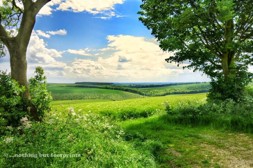
The path then led us up to a field side where, looking back, I could see across to part of the route we'd walked on the Wolds Way, just one week ago. The "big sky" view and cloudscape was wonderful.
Yorkshire Wolds big sky
The walking was easy along the field side, although the day was becoming increasingly hot and humid and I was thankful not to be carrying my large backpack. Although we'd had more than our share of wet weather when we'd walked the Wolds Way, I have to admit this usually resulted in a more comfortable temperature.
Along the Wolds Way
At a point where the fieldside path turned a corner, a gap in the hedge provided us with a view over the Vale of York to a distant power station. There were darker clouds gathering in the west, but they appeared to be moving southwards and thus passed us by, leaving us to bask in hot sunshine for the majority of our walk.
A glimpse of the Vale of York
After crossing the busy A614 the Wolds Way follows a quiet country road towards Londesborough Park. The lack of hedges along this pleasant little lane provided open views across the countryside. It was a delightful scene and such a peaceful place we really dawdled along here, drinking it all in. This short section alone made me very glad we'd decided to walk the "missing link". To have missed it would have denied us the pleasure of a particularly beautiful section of the trail.
Beautiful Yorkshire Wolds scenery
A short walk along the lane brought us to the point where the trail turns into Londesborough Park. On day three of our Wolds Way walk we had entered Londesborough Park through a gateway at its western edge. Now we were entering to the south to walk through the park and eventually meet up with our previous route from Market Weighton, which had been along a fairly uninteresting track. Today's route was much more picturesque, beginning with a field landscaped with mature oaks and chestnuts.
Entering Londesborough Park
At the edge of the field the path narrowed as it approached a little wooden bridge beyond which we could see the route ahead, passing through an avenue of trees.
Approaching a little bridge
The little bridge carried us over the edge of a delightful pond where we paused for a while to watch tadpoles and minnows, a treat we had missed on our original Wolds Way walk.
A beautiful pond in Londesborough Park
The path then led us across the parkland along a grassy but well defined path, climbing gently towards the village of Londesborough, and passing some wonderful mature trees in full leaf.
An avenue of trees
Leaving the grassy path we joined a track which met up with the route we had previously followed from Market Weighton, close to a brick built deer shelter which I describe in my blog for day three of our Wolds Way walk. At this point the trail turns into the village of Londesborough and this part of the walk is also covered in my blog for our third day on the trail.
The two trails meet
We followed the course of the Wolds Way as far as a crossroads on the other side of the village. At this point the Wolds Way carries straight on, following a country lane uphill as it heads to the village of Nunburnholme. Today though we turned right at the crossroads and began a lengthy section of walking along roads, measuring approximately four miles. To begin with the single track road was quite busy with traffic and cyclists and we found ourselves frequently having to step up onto the grass verge. However, after about a mile we turned onto a quieter road. Our route since Londesborough had been steadily climbing and as I turned to look back at the junction I once again had a view over to the distant power station, beyond which the outline of the Pennines was just visible on the hazy horizon. Even though the sky seemed to be filled with threatening clouds, the sun was still shining and curiously it continued to do so, in spite of all the clouds.
Distant power station
I have to admit, I'm not the biggest fan of walking along roads and I found the next section of our route rather tedious at times. However, this second stretch of road walking was undeniably peaceful and after about a mile we were rewarded with a glorious view from the top of Nunburnholme Wold, looking down over the edge of the Forestry Commission owned woodland of Rosemary Coombe.
The view down to Rosemary Coombe
After another mile we turned right and followed another quiet road downhill to meet the busy main road. Just before crossing the road we paused to take a look at a sign in the hedgerow marking the finishing point of the Kiplingcotes racecourse. The Kiplingcotes Derby is thought to be the oldest horse race in England, reputedly having been held every year since 1519. It takes place on the third Thursday of March every year and most of the competitors are amateur riders, mostly from the local farming community. The only rules state that riders must weigh at least ten stones and that if the race is not run one year then it must never be run again. Apparently, in the particularly severe winter of 1947 one farmer led his horse around the course through snowdrifts to ensure that the race would survive. Again, in 2001, at the time of the foot and mouth epidemic, a single horse was ridden around the track to ensure the race's survival. The "racecourse" is actually made up of a series of rough farm tracks and fields, some of which we were about to walk along.
Kipingcotes Finishing Post
The main road was also rather like a race track, with cars travelling at great speed and overtaking along the straight section where we waited to cross. Once on the other side we immediately joined a muddy, heavily rutted track which we were to follow for the next two miles. It seemed a little hard to believe, but this was actually the racecourse. And this was summer. I couldn't imagine what it must be like in the winter and how anyone managed to race horses along it.
This is a racecourse???
A little further along though the track widened out. It was still deeply rutted in places but at least now there was some relatively level ground too.
Kiplingcotes Racecourse
Our walk along this section of the "racecourse" ended where the track merged onto a country lane. Here we crossed an old bridge over the former Driffield to Market Weighton line. I peered over the top and through the masses of nettles growing up the embankment I could just make out the course of the old line, now mostly obscured by bushes and undergrowth.
Abandoned and overgrown railway line
There followed another stretch of road walking, this time for just under two miles, to the former Kiplingcotes railway station, which is now home to a furniture saleroom. It was closed when we arrived but we could see that even the old signal box was being used as a form of showroom for what looked like wicker furniture.
Kiplingcotes Station
From Kiplincotes Station we turned onto the old railway line, heading in the direction of Market Weighton. This is the Hudson Way, a ten mile long stretch of former railway line which runs from Beverley to Market Weighton.
Leaving Kiplingcotes Station
Normally this route would be busy with walkers and cyclists, but as it was now late in the afternoon we had the path to ourselves and enjoyed a pleasant walk of around two miles which took us to where the Wolds Way divides at Market Weighton Gap.
The Hudson Way
From this point we were back on the Yorkshire Wolds Way again, following the section we had previously missed as it led us along a quiet country lane for around a mile, back to the village of Goodmanham.
Peaceful country lane back to Goodmanham
The Goodmanham Arms was very much open for business when we arrived back in the village. In fact, it was very busy indeed. Most people were sitting outside, enjoying the afternoon sunshine and inside was a little quieter, enabling me to have a quick look around. The inside of the pub is rather like a museum of rural life with all kinds of items from a bygone age on display. There were lanterns, kettles, school bells, old photographs - even an old motorcycle. It was fascinating. It was also very warm inside and so, like everyone else, we opted to take our drinks outside. The pub has its own micro brewery and we selected a glass of a ruby ale called Ragged Robyn which was very good indeed. As nominated driver for the day, I was rather disappointed to have to be limited to just half a pint and I have promised to return on a quieter day, when I can have a proper look around and sample more than just one small glass.
Home to some very fine ale indeed
Sitting out in the beer garden we reflected on the day's walk. It had been good to have had the opportunity to walk the parts of the Wolds Way we'd previously missed, and the section from Goodmanham to Londesborough was truly memorable. The rest of the walk though, along mile after mile of road, had been a bit of a trudge at times, the main point of interest being Kiplingcotes racecourse. Remarkably, the sky had been filled with clouds for the entire day and yet at the same time we had enjoyed uninterrupted sunshine. As we sat in the garden enjoying our beer, I looked up to see the most magnificent cloudscape. I couldn't identify all the types of cloud, but that didn't matter. Just gazing up and sipping a beer was a lovely way to end any day.
A cloudscape
Directions for this walk:
From the centre of Goodmanham take the footpath signposted Yorkshire Wolds Way at the side of All Hallows Church. The clearly marked route of the Wolds Way can then be followed all the way to the village of Londesborough, through the village and up to a road junction. The Wolds Way continues straight on but this route turns to the right, climbing steadily up a country road for about a mile. At the first road junction turn right onto a road signposted to Middleton. After approximately two miles turn right again along a road signposted to Market Weighton. Cross the busy A163 to walk straight on along the Kiplingcotes racecourse. Keep straight on and the track eventually becomes a surface road. After the road crosses over the disused railway line keep straight on for around another mile or so until reaching a crossroads. Turn right, following the signs for Kiplingcotes Station. At the station turn right onto the Hudson Way and follow this all the way to where it meets the road at Market Weighton Gap. Here you will again encounter Wolds Way signposts once again. Follow the route marked Goodmanham back to the village. Total distance - 13 miles.
Coming soon....My next blog will feature a walk on the North York Moors from Bilsdale across to Bransdale, which we completed the week before embarking on our Yorkshire Wolds Way adventure.


Hi Nothing but Footprints. Here at the Yorkshire Wolds Way Partnership we have loved your brilliant blog and your great photos (even the odd wet ones!)
ReplyDeleteYou have only made one error as far as we can see - the official route for the Yorkshire Wolds Way has passed directly through Wharram Percy for many years now (probably about 15). Many thanks for the great blog
Thank you for your lovely comments, Malcolm. I hadn't realised that the Wharram Percy route had been incorporated into the trail. When we first attempted the walk 17 years ago it wasn't on the official route and, I'm almost embarrassed to admit, the fact that it had since been included had passed me by. I've amended my blog to correct this error. Thanks for pointing it out and thank you to the Yorkshire Wolds Way Partnership for maintaining such a wonderful National Trail.
Delete