Kirbymoorside, Gillamoor and Kirkdale (North York Moors)
Of all the towns and villages within the North York Moors National Park, Kirbymoorside is perhaps the one we pass through the most regularly without actually stopping to visit. This small market town, which has a population of around 3,000, sits half way between the more popular destinations of Helmsley and Pickering. Although it was once on the main coaching route between York and Scarborough, today the town centre is bypassed by the A170 which skirts past the southern edge of the town. I suspect, like us, most visitors to the moors simply drive by on their way from one "honeypot" destination to another, without actually turning into the town itself. I can't help but wonder if this isn't to the relief of many residents of peaceful Kirbymoorside.
Both Helmsley and Pickering are home to impressive castle ruins, and perhaps this is one of the reasons Kirbymoorside has not witnessed the same growth in tourism as its neighbouring towns. There was a castle here once, but it was a wooden construction which fell into disrepair around the time of the Black Death in the mid fourteenth century. A fortified manor house was then built in its place, only a few fragments of which are visible today.
The name Kirbymoorside has been shortened over time from "Kirk-by-moorside", being a combination of "kirk" (church) and the Viking word "by" for settlement, meaning quite literally "a settlement with a church by the side of the moors".
The town was very quiet indeed when, on a Sunday morning in late July, we set off from the market place at the start of a circular walk which was to take us to the edge of the moors and back through the valley of Kirkdale.
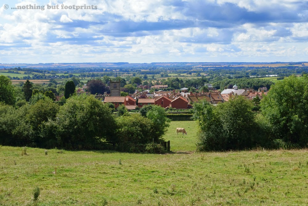
We left the town by a narrow country lane to the north which gradually ascended and soon gave us a view over the rooftops and beyond to the Vale of Pickering. It was a warm and muggy morning, with plenty of sunshine but also an increasing amount of cloud. Climbing even the gentle incline out of the town felt harder than it should have done in the sultry heat.
After a mile or so we turned onto a track by the side of a plantation, thankful for the shade provided by the trees. It was a beautiful July morning with the hedgerows in full leaf and noisy with birdsong.

Our route turned off the track into Hagg Wood, following a path of churned up mud. Thankfully the thickest mud could mostly be avoided by walking along the edges of the path.

This woodland was obviously used to rear pheasants and, as we left the cover of the trees, a young bird stood on the path ahead of us. It had yet to grow its tail feathers and looked rather strange and almost comical. I was surprised that it let us get quite close before it ran for cover into the undergrowth. "You need to get scared of people pretty soon little fella", I shouted after it. "The next shot probably won't be from a camera."

Ahead of us the path was wider and drier as it led us out into open countryside again. In the distance we could see the higher ground of the moors, with just a hint of purple where the heather was showing early signs of flowering.

We enjoyed a welcome break at the Royal Oak, in the village of Gillamoor, where we sat for a while to drink a beer in the sunshine. This lovely little moorland village is situated at the top of one of the Tabular Hills with steep valleys on either side. Our route out of the village took us by the church, which is perched on an escarpment 150 feet above the River Dove. A plaque set into the wall of the church quotes a line from a hymn by John Keble, referring in this instance to what awaits the visitor just a few feet further along the road.

Gillamoor is perhaps best known for its "Surprise View", just to the left of the church. In the height of summer the view is partially obscured by trees and bracken, but it was still very beautiful; a patchwork quilt of fields merging into the heather moorland at the eastern edge of Farndale.

From Gillamoor we walked along the side of the road, steeply downhill, before turning onto a quiet country lane where some lovely wild flowers caught my eye. I wasn't sure what they were at the time and so I took a photo and have since been able to identify them as Field Scabious.

As we headed in the direction of Kirkdale we passed through a field of cattle. They were mildly curious but didn't venture near us, although I could sense that they were watching us all the while until we left their field.

Our route continued along another quiet country lane before turning onto a woodland path which ran along the side of Kirkdale, a beautiful wooded gorge at the southern end of Bransdale. Here the Hodge Beck flows from its source near the settlement of Cockayne to join with the River Dove. To begin with the path was a little overgrown with nettles (always a pain when you're wearing shorts!) but thankfully it soon widened to reveal a clearer surface.

After a mile or so we descended from the woods to walk along a forestry track by the side of Hodge Beck until we reached a mill where the Hodge Beck disappears underground at an area known as Hold Caldron. The thick, lush foliage growing around the beck made taking a photograph very difficult.

Our route now followed an access road for half a mile or so, passing by an old disused lime kiln.

After walking along a couple of fieldside paths we found ourselves at what, for me, was the highlight of our walk - the charming little Anglo Saxon church of St Gregory's Minster. Standing alone in a peaceful valley, surrounded by woodland, the church is dedicated to Saint Gregory, who was pope from AD 590 to 604. As pope, Gregory initiated the conversion of the Anglo-Saxon peoples to Christianity by sending Augustine to King Ethelbert of Kent in 597. A generation later one of Augustine's companions, Paulinus, brought Christianity to northern England and baptised Edwin, king of Northumbria, in 627. St Gregory's Minster was built in 1055 on the site of an earlier Saxon church.

As we headed along the road, back in the direction of Kirbymoorside, we crossed a ford over the course of Hodge Beck. The ford was dry and there was very little evidence of the stream (which I believe is still mostly subterranean at this point), but judging by the discolouration on the nearby depth gauge, we could see that sometimes at this point it can run to a depth of up to three feet.

A little further along the road we turned into a wooded area, in search of the Kirkdale Cave. Here, in 1821, workmen quarrying limestone discovered a cave containing a large collection of fossilized animal bones, embedded in a layer of silt within the rocks. Later analysis identified the bones to include those of elephants, hippopotamuses, rhinoceroses, hyenas, bison, giant deer, smaller mammals and birds. This was a highly significant find, remaining to this day the northernmost place where hippopotamus bones have been discovered, and the area has been designated a Site of Special Scientific Interest.
We tramped around for a while along the woodland floor, which was coated with very sticky and smelly mud. Eventually I spotted a fissure in the rock face and took a photo. It didn't seem to be wide enough to be the entrance to a cave but it was the biggest aperture in the rock face that I could see. I later discovered that the cave entrance is actually higher up in the rocks, and I plan to return to the area one day to get a proper photo. In the meantime, the one below is the best I can offer, but it does give a general idea of the surrounding environment.

Our walk back to Kirbymoorside took us across farmland, through a field of sheep, before emerging into a small housing estate on the western edge of the town.

This had been a fairly easy walk of just over 12 miles with plenty of interest along the way. Back in Kirbymoorside the Kings Head Hotel (a former coaching inn) supplied us with an excellent Sunday lunch and a most enjoyable end to the day.
Directions for this walk:
Leave Kirbymoorside at the northern end of the town by Castlegate, turning right onto Park Lane. Follow Park Lane until it bends to the right and a track leads straight on into Hagg Wood. This path takes you through the woodland, downhill and through a clearing before a path to the left leads across a field to a lane which will take you into Gillamoor. Turn right through Gillamoor, leaving the village by the side of the church (and Surprise View), then follow the road downhill until it bends off to the right and a farm track takes you straight on at Faddell Rigg. This public bridleway passes across farmland until it turns off to the left to join a road which should be followed for a couple of hundred yards or so before turning into an access road. Here a sign states that the road is private, but a short distance ahead there's a public footpath/bridleway sign. This leads across pasture land, around the side of a hill, before emerging onto another country lane. Here turn left and follow the lane to a point known as "The Brow" where a narrow footpath leads into woodland. This path will eventually widen out and can be followed, through woodland to begin with and then along a forestry road, all the way to Hold Caldron. At this point an access road should be followed steeply uphill, passing an old kiln on the right. Where the road turns to the right a public footpath carries straight on along a field side, eventually arriving by the side of St Gregory's Minster. From the church follow the lane to a crossroads where ahead a path leads across a field, alongside a wood and over another couple of fields which leads back to the western edge of Kirbymoorside.
Total distance = 12.25 miles.

Coming soon...We return to the Lake District where we pay a visit to the Old Man of Coniston and enjoy some excellent locally brewed ale.
Both Helmsley and Pickering are home to impressive castle ruins, and perhaps this is one of the reasons Kirbymoorside has not witnessed the same growth in tourism as its neighbouring towns. There was a castle here once, but it was a wooden construction which fell into disrepair around the time of the Black Death in the mid fourteenth century. A fortified manor house was then built in its place, only a few fragments of which are visible today.
The name Kirbymoorside has been shortened over time from "Kirk-by-moorside", being a combination of "kirk" (church) and the Viking word "by" for settlement, meaning quite literally "a settlement with a church by the side of the moors".
The town was very quiet indeed when, on a Sunday morning in late July, we set off from the market place at the start of a circular walk which was to take us to the edge of the moors and back through the valley of Kirkdale.
We left the town by a narrow country lane to the north which gradually ascended and soon gave us a view over the rooftops and beyond to the Vale of Pickering. It was a warm and muggy morning, with plenty of sunshine but also an increasing amount of cloud. Climbing even the gentle incline out of the town felt harder than it should have done in the sultry heat.
Kirbymoorside from Park Lane
After a mile or so we turned onto a track by the side of a plantation, thankful for the shade provided by the trees. It was a beautiful July morning with the hedgerows in full leaf and noisy with birdsong.
Summer hedgerow
Our route turned off the track into Hagg Wood, following a path of churned up mud. Thankfully the thickest mud could mostly be avoided by walking along the edges of the path.
Muddy path through the woodlands
This woodland was obviously used to rear pheasants and, as we left the cover of the trees, a young bird stood on the path ahead of us. It had yet to grow its tail feathers and looked rather strange and almost comical. I was surprised that it let us get quite close before it ran for cover into the undergrowth. "You need to get scared of people pretty soon little fella", I shouted after it. "The next shot probably won't be from a camera."
A young pheansant
Ahead of us the path was wider and drier as it led us out into open countryside again. In the distance we could see the higher ground of the moors, with just a hint of purple where the heather was showing early signs of flowering.
Leaving the woods
We enjoyed a welcome break at the Royal Oak, in the village of Gillamoor, where we sat for a while to drink a beer in the sunshine. This lovely little moorland village is situated at the top of one of the Tabular Hills with steep valleys on either side. Our route out of the village took us by the church, which is perched on an escarpment 150 feet above the River Dove. A plaque set into the wall of the church quotes a line from a hymn by John Keble, referring in this instance to what awaits the visitor just a few feet further along the road.
Ode to a fine view
Gillamoor is perhaps best known for its "Surprise View", just to the left of the church. In the height of summer the view is partially obscured by trees and bracken, but it was still very beautiful; a patchwork quilt of fields merging into the heather moorland at the eastern edge of Farndale.
Surprise View
From Gillamoor we walked along the side of the road, steeply downhill, before turning onto a quiet country lane where some lovely wild flowers caught my eye. I wasn't sure what they were at the time and so I took a photo and have since been able to identify them as Field Scabious.
Field Scabious
As we headed in the direction of Kirkdale we passed through a field of cattle. They were mildly curious but didn't venture near us, although I could sense that they were watching us all the while until we left their field.
Curious cattle
Our route continued along another quiet country lane before turning onto a woodland path which ran along the side of Kirkdale, a beautiful wooded gorge at the southern end of Bransdale. Here the Hodge Beck flows from its source near the settlement of Cockayne to join with the River Dove. To begin with the path was a little overgrown with nettles (always a pain when you're wearing shorts!) but thankfully it soon widened to reveal a clearer surface.
Path through the trees
After a mile or so we descended from the woods to walk along a forestry track by the side of Hodge Beck until we reached a mill where the Hodge Beck disappears underground at an area known as Hold Caldron. The thick, lush foliage growing around the beck made taking a photograph very difficult.
Hold Caldron
Our route now followed an access road for half a mile or so, passing by an old disused lime kiln.
Old lime kiln
After walking along a couple of fieldside paths we found ourselves at what, for me, was the highlight of our walk - the charming little Anglo Saxon church of St Gregory's Minster. Standing alone in a peaceful valley, surrounded by woodland, the church is dedicated to Saint Gregory, who was pope from AD 590 to 604. As pope, Gregory initiated the conversion of the Anglo-Saxon peoples to Christianity by sending Augustine to King Ethelbert of Kent in 597. A generation later one of Augustine's companions, Paulinus, brought Christianity to northern England and baptised Edwin, king of Northumbria, in 627. St Gregory's Minster was built in 1055 on the site of an earlier Saxon church.
St Gregory's Minster, Kirkdale
As we headed along the road, back in the direction of Kirbymoorside, we crossed a ford over the course of Hodge Beck. The ford was dry and there was very little evidence of the stream (which I believe is still mostly subterranean at this point), but judging by the discolouration on the nearby depth gauge, we could see that sometimes at this point it can run to a depth of up to three feet.
Ford over Hodge Beck
A little further along the road we turned into a wooded area, in search of the Kirkdale Cave. Here, in 1821, workmen quarrying limestone discovered a cave containing a large collection of fossilized animal bones, embedded in a layer of silt within the rocks. Later analysis identified the bones to include those of elephants, hippopotamuses, rhinoceroses, hyenas, bison, giant deer, smaller mammals and birds. This was a highly significant find, remaining to this day the northernmost place where hippopotamus bones have been discovered, and the area has been designated a Site of Special Scientific Interest.
We tramped around for a while along the woodland floor, which was coated with very sticky and smelly mud. Eventually I spotted a fissure in the rock face and took a photo. It didn't seem to be wide enough to be the entrance to a cave but it was the biggest aperture in the rock face that I could see. I later discovered that the cave entrance is actually higher up in the rocks, and I plan to return to the area one day to get a proper photo. In the meantime, the one below is the best I can offer, but it does give a general idea of the surrounding environment.
Somewhere near Kirkdale Cave
Our walk back to Kirbymoorside took us across farmland, through a field of sheep, before emerging into a small housing estate on the western edge of the town.
Returning to Kirbymoorside
This had been a fairly easy walk of just over 12 miles with plenty of interest along the way. Back in Kirbymoorside the Kings Head Hotel (a former coaching inn) supplied us with an excellent Sunday lunch and a most enjoyable end to the day.
Directions for this walk:
Leave Kirbymoorside at the northern end of the town by Castlegate, turning right onto Park Lane. Follow Park Lane until it bends to the right and a track leads straight on into Hagg Wood. This path takes you through the woodland, downhill and through a clearing before a path to the left leads across a field to a lane which will take you into Gillamoor. Turn right through Gillamoor, leaving the village by the side of the church (and Surprise View), then follow the road downhill until it bends off to the right and a farm track takes you straight on at Faddell Rigg. This public bridleway passes across farmland until it turns off to the left to join a road which should be followed for a couple of hundred yards or so before turning into an access road. Here a sign states that the road is private, but a short distance ahead there's a public footpath/bridleway sign. This leads across pasture land, around the side of a hill, before emerging onto another country lane. Here turn left and follow the lane to a point known as "The Brow" where a narrow footpath leads into woodland. This path will eventually widen out and can be followed, through woodland to begin with and then along a forestry road, all the way to Hold Caldron. At this point an access road should be followed steeply uphill, passing an old kiln on the right. Where the road turns to the right a public footpath carries straight on along a field side, eventually arriving by the side of St Gregory's Minster. From the church follow the lane to a crossroads where ahead a path leads across a field, alongside a wood and over another couple of fields which leads back to the western edge of Kirbymoorside.
Total distance = 12.25 miles.
Coming soon...We return to the Lake District where we pay a visit to the Old Man of Coniston and enjoy some excellent locally brewed ale.


Comments
Post a Comment