High Street, Haweswater & Penrith (Lake District)
When I first began my mission to climb all 214 Wainwright Lakeland fells (just over a year ago), I also started my own sub-list with the heading "Lakeland Priorities". Let's face it, 214 hills/mountains is very ambitious, particularly for someone like me, who until quite recently had struggled to get up Roseberry Topping. And although I am something of a completist, I'm by no means bagging hills and mountains just for the sake of putting ticks in boxes. To be honest, if I don't climb all 214 Wainwrights it won't really bother me. My main objective is enjoyment. And so with that in mind I started a list to prioritise the hills and mountains I'm especially keen to climb.
In early September we decided that we would like to become better acquainted with the Cumbrian town of Penrith. It's one of those places I've passed through many times in my life without ever actually stopping to take a proper look around. Over the past year we've often stopped on the outskirts of the town, to visit stores such as Go Outdoors or Morrisons, but we hadn't ventured into the town centre. When it comes to visiting the northern part of the Lake District, Keswick has thus far taken precedence. Penrith, however, seemed to be perfectly positioned to be the base for the next mountain on my list of "Lakeland Priorities"; the fascinating and enticing High Street.
Rather surprisingly, finding accommodation in Penrith proved to be something of a challenge. Mistakenly I thought that because Penrith isn't in the National Park, and because we wanted to visit after the school holidays had come to an end, then we would be spoilt for choice. Not so! As regular readers will know, we're not particularly keen on staying in guest houses and much prefer a pub, where we can relax after a walk with a few drinks and a meal, blending in with locals as opposed to feeling as if we're staying in someone else's house. When it came to finding accommodation in Penrith, however, after a couple of hours of fruitless searching I had to abandon the idea of staying in a pub, Instead I somewhat reluctantly booked a room for two nights at the Brandelhow Guest House, which is located in the centre of the town. Although I didn't realise it at the time, this turned out to be an excellent decision. The Brandelhow was a fabulous place to stay, with a very comfortable and spotlessly clean room, and the most amazing choice of breakfasts ever. It was also within easy walking distance of a good selection of pubs, eateries and shops.
We spent an enjoyable Saturday afternoon getting to know Penrith, which included a visit to the Rheged Centre on the outskirts of town - a strange place which seems to combine a visitor centre with a large delicatessen, cafe, specialised cinema and a small number of retail outlets. Sadly, we arrived a little too late to see the screening of "Scafell Pike: A year in the life of a mountain", which is a film I'd very much like to see. Instead we spent a happy few hours browsing the shops, both at Rheged and in the town centre, and then in the evening we embarked upon our very own Penrith mini pub crawl. (Observant readers may recall that I had recently put myself on a diet. Prior to this trip I had lost 8lbs and I therefore felt entitled to a short break, particularly where beer was concerned!)
I was both surprised and relieved to wake on Sunday morning to discover that not only did I have a clear head and bags of energy, but also that the sun was shining brightly. Fortified by a wonderful breakfast of pancakes, bacon and maple syrup, we set off on the short drive from Penrith, along the shores of Haweswater to the small car park at Mardale Head.
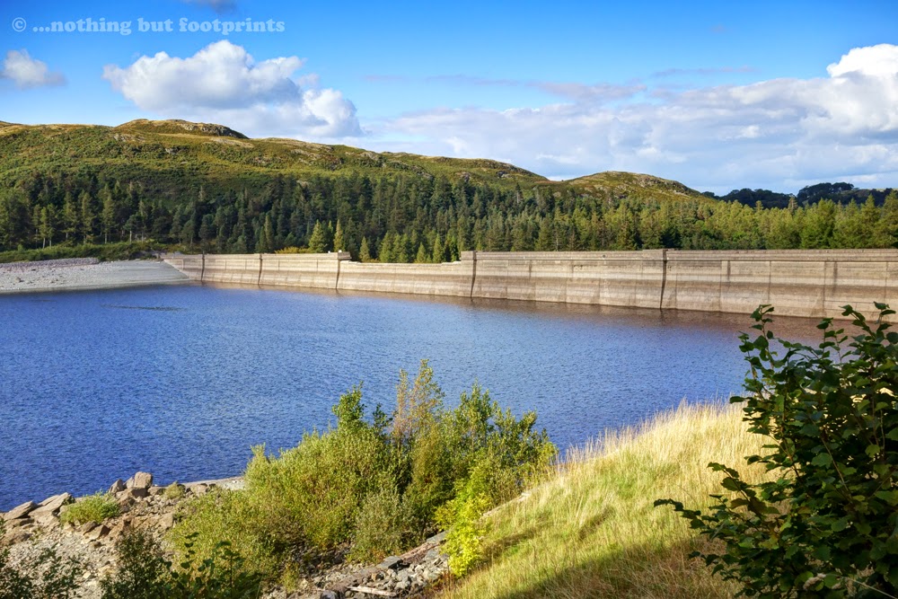
Today Haweswater is a reservoir, but originally it was a lake - the highest in the Lake District. In 1935 all the farms and buildings of the villages of Mardale Green and Measand were demolished and a dam was built which raised the water level by 95 feet, flooding the valley and creating the four mile long Haweswater Reservoir. On the way into the valley we stopped for a short while to take a look at the dam, which was partly constructed from stones taken from the dismantled Mardale Green church.
Even though it was still reasonably early, by the time we arrived at Mardale Head the car park was almost full and we were lucky to find a space. Looking across to the head of the reservoir from the car park I could just make out the outline of what looked like a road disappearing into the water. In dry periods I understand that some of the remains of the buildings of Mardale Green appear out of the water, which is something I find a little eerie.

Our route from Mardale Head was to take us up to the summit of High Street, from where I had planned a ridge walk round the valley head, taking in two further Wainwright fells - Mardale Ill Bell and Harter Fell. We started out by crossing a stream which fed into Haweswater before climbing steadily along a rocky path above the western side of the reservoir. Looking back we had an impressive view of Harter Fell and our eventual return route to the car park.

As the path gradually ascended more of the walls of Mardale Green became visible in the water below. The waterline hadn't receded sufficiently for us to be able to make out any discernible buildings, but I still thought it was a bit spooky.

After walking for half a mile or so above the shore of the reservoir, our path turned back in the direction we had just walked, but all the while ascending the fellside. Before we began the climb though, I paused to enjoy the view down Riggindale to the peak of Kidsty Pike on the right.

A short climb later and we were rewarded with a magnificent view of Haweswater, with the little promontory known as Speaking Crag in the foreground.

As we climbed I had one final, bird's eye view of ruins protruding from the waters below. I didn't know what it was I could see exactly, but it appeared to be a boundary wall. I thought for a while about the church which had been dismantled and all the bodies from the churchyard which had been exhumed and reburied in the churchyard at Shap.

Now the climbing proper started as we began the ascent of Rough Crag - the route which Wainwright had described as "the connoisseur's route up High Street". We hadn't been climbing for long before I realised exactly what he had meant. It was stupendously good! Below us to the north-east the view of Haweswater and the distant Pennines became increasingly spectacular with every few feet of ascent.

On the map and from the lower ground Rough Crag looked rather sharp and precipitous, but in actual fact the walking was straightforward, with stretches of relatively level ground punctuated by easy and highly enjoyable scrambles. I absolutely loved it and wholeheartedly agreed with Wainwright's assessment.

Eventually we found ourselves looking down upon Blea Water, one of two small tarns we were to encounter on this route. The water was sparkling in the sunlight and looked quite inviting, although as Blea Water is the deepest mountain tarn in the Lake District (200 feet or 61 metres), I should imagine it's very cold indeed.

As we climbed it suddenly dawned on me that I was finding this ascent noticeably easier than previous climbs, which must have been due to having shed a few pounds. Eight pounds doesn't sound much, but it's actually the equivalent of four bags of sugar and I was already noticing a difference. Mostly I was stopping to admire the view and not really needing to catch my breath as often as I would have done previously. And what a view it was!

A little higher up the ridge provided us with a lovely view over Blea Water to our second intended peak of the day - Mardale Ill Bell.

As the summit approached I paused and looked with some trepidation at the final section of our ascent, known as the Long Stile. From where I was standing it was hard to make out a discernible path, apart from a faint line towards the very top. Apart from that, the way ahead seemed to mostly entail climbing up bare rock. Feeling a little concerned, I pressed on.

I really need not have worried. Although there were a few scrambles, and the last portion of the route was a very steep, shale-covered path, it really wasn't difficult at all and we soon found our way onto the broad summit of High Street.

At 2,717 feet High Street is the highest of the Far Eastern Fells and is so named because of the Roman road which crossed the top on its journey between the forts at Brougham (near Penrith) and Ambleside. In the 18th and 19th centuries the spacious summit of High Street was used for summer fairs and sheep sales and was also the location for a horse race, which has led to the alternative name of Racecourse Hill. The views from the summit were wonderful and as we took a break for our lunch I was able to identify a distant Blencathra.

And over to the west, beyond the Helvellyn range, I could clearly see the unmistakeable profile of Great Gable along with Scafell and Scafell Pike.

After lunch I went off in search of the line of the Roman road, but as I wasn't entirely sure what to look for, I'm not convinced I found it. It didn't really matter though, as the views all around were so spectacular.

As we set off along the ridge of Racecourse Hill in the direction of Mardale Ill Bell, I suddenly caught sight of a distant Ingleborough, its distinctive shape clearly visible on the horizon.

Over to the south we had a clear view of Windermere and beyond across Morecambe Bay. I squinted into the sunlight to see if I could make out the shape of Blackpool Tower, but the light was just a little too hazy.


After Mardale Ill Bell (2,496 feet) we descended to Nan Bield Pass, looking down to Kentmere Reservoir. We could have descended to Mardale Head from this point, but I still had plenty of energy to spare and so we continued, with an ascent of Harter Fell.

Towards the top of Harter Fell I paused to look down on Small Water Tarn and beyond to Mardale Head where sunlight was glinting off the parked cars.

The summit of Harter Fell (2,539 feet) is marked by one of those quirky little cairns made up of rocks and rusty metal.

Before we began our descent I walked out to the edge of the fell and was treated to the most magnificent aerial view of Haweswater and beyond to the distant Pennines.

Our route down from Harter Fell led us in an almost easterly direction. I could see Ingleborough again on the horizon and, for a time, it didn't look too far away. It almost seemed as if our path would lead us straight there and I felt as if I could keep on walking. The Howgill Fells were also visible on the horizon and, not for the first time, I resolved to go walking there before too long.

Our route down to Mardale Head soon came into view, snaking its way between Harter Fell and Branstree. This was a very pleasant, reasonably gentle descent, leading us directly back to our car and the end of what had been a truly memorable walk.

Our weekend in Penrith had been highly enjoyable. The town isn't as tourist-orientated as the likes of Keswick or Ambleside but we liked it very much and wouldn't hesitate to return.
Coming soon...We return to the Yorkshire Wolds for a walk from the village of Settrington including a short section of the Yorkshire Wolds Way.
In early September we decided that we would like to become better acquainted with the Cumbrian town of Penrith. It's one of those places I've passed through many times in my life without ever actually stopping to take a proper look around. Over the past year we've often stopped on the outskirts of the town, to visit stores such as Go Outdoors or Morrisons, but we hadn't ventured into the town centre. When it comes to visiting the northern part of the Lake District, Keswick has thus far taken precedence. Penrith, however, seemed to be perfectly positioned to be the base for the next mountain on my list of "Lakeland Priorities"; the fascinating and enticing High Street.
Rather surprisingly, finding accommodation in Penrith proved to be something of a challenge. Mistakenly I thought that because Penrith isn't in the National Park, and because we wanted to visit after the school holidays had come to an end, then we would be spoilt for choice. Not so! As regular readers will know, we're not particularly keen on staying in guest houses and much prefer a pub, where we can relax after a walk with a few drinks and a meal, blending in with locals as opposed to feeling as if we're staying in someone else's house. When it came to finding accommodation in Penrith, however, after a couple of hours of fruitless searching I had to abandon the idea of staying in a pub, Instead I somewhat reluctantly booked a room for two nights at the Brandelhow Guest House, which is located in the centre of the town. Although I didn't realise it at the time, this turned out to be an excellent decision. The Brandelhow was a fabulous place to stay, with a very comfortable and spotlessly clean room, and the most amazing choice of breakfasts ever. It was also within easy walking distance of a good selection of pubs, eateries and shops.
We spent an enjoyable Saturday afternoon getting to know Penrith, which included a visit to the Rheged Centre on the outskirts of town - a strange place which seems to combine a visitor centre with a large delicatessen, cafe, specialised cinema and a small number of retail outlets. Sadly, we arrived a little too late to see the screening of "Scafell Pike: A year in the life of a mountain", which is a film I'd very much like to see. Instead we spent a happy few hours browsing the shops, both at Rheged and in the town centre, and then in the evening we embarked upon our very own Penrith mini pub crawl. (Observant readers may recall that I had recently put myself on a diet. Prior to this trip I had lost 8lbs and I therefore felt entitled to a short break, particularly where beer was concerned!)
I was both surprised and relieved to wake on Sunday morning to discover that not only did I have a clear head and bags of energy, but also that the sun was shining brightly. Fortified by a wonderful breakfast of pancakes, bacon and maple syrup, we set off on the short drive from Penrith, along the shores of Haweswater to the small car park at Mardale Head.
Today Haweswater is a reservoir, but originally it was a lake - the highest in the Lake District. In 1935 all the farms and buildings of the villages of Mardale Green and Measand were demolished and a dam was built which raised the water level by 95 feet, flooding the valley and creating the four mile long Haweswater Reservoir. On the way into the valley we stopped for a short while to take a look at the dam, which was partly constructed from stones taken from the dismantled Mardale Green church.
Haweswater Dam
Even though it was still reasonably early, by the time we arrived at Mardale Head the car park was almost full and we were lucky to find a space. Looking across to the head of the reservoir from the car park I could just make out the outline of what looked like a road disappearing into the water. In dry periods I understand that some of the remains of the buildings of Mardale Green appear out of the water, which is something I find a little eerie.
Mardale Head
Our route from Mardale Head was to take us up to the summit of High Street, from where I had planned a ridge walk round the valley head, taking in two further Wainwright fells - Mardale Ill Bell and Harter Fell. We started out by crossing a stream which fed into Haweswater before climbing steadily along a rocky path above the western side of the reservoir. Looking back we had an impressive view of Harter Fell and our eventual return route to the car park.
Mardale Head with Harter Fell
As the path gradually ascended more of the walls of Mardale Green became visible in the water below. The waterline hadn't receded sufficiently for us to be able to make out any discernible buildings, but I still thought it was a bit spooky.
Remains of farm walls
After walking for half a mile or so above the shore of the reservoir, our path turned back in the direction we had just walked, but all the while ascending the fellside. Before we began the climb though, I paused to enjoy the view down Riggindale to the peak of Kidsty Pike on the right.
Riggindale and Kidsty Pike
A short climb later and we were rewarded with a magnificent view of Haweswater, with the little promontory known as Speaking Crag in the foreground.
Haweswater
As we climbed I had one final, bird's eye view of ruins protruding from the waters below. I didn't know what it was I could see exactly, but it appeared to be a boundary wall. I thought for a while about the church which had been dismantled and all the bodies from the churchyard which had been exhumed and reburied in the churchyard at Shap.
Ruins under water
Now the climbing proper started as we began the ascent of Rough Crag - the route which Wainwright had described as "the connoisseur's route up High Street". We hadn't been climbing for long before I realised exactly what he had meant. It was stupendously good! Below us to the north-east the view of Haweswater and the distant Pennines became increasingly spectacular with every few feet of ascent.
View from Rough Crag
On the map and from the lower ground Rough Crag looked rather sharp and precipitous, but in actual fact the walking was straightforward, with stretches of relatively level ground punctuated by easy and highly enjoyable scrambles. I absolutely loved it and wholeheartedly agreed with Wainwright's assessment.
Rough Crag
Eventually we found ourselves looking down upon Blea Water, one of two small tarns we were to encounter on this route. The water was sparkling in the sunlight and looked quite inviting, although as Blea Water is the deepest mountain tarn in the Lake District (200 feet or 61 metres), I should imagine it's very cold indeed.
Blea Water Tarn
As we climbed it suddenly dawned on me that I was finding this ascent noticeably easier than previous climbs, which must have been due to having shed a few pounds. Eight pounds doesn't sound much, but it's actually the equivalent of four bags of sugar and I was already noticing a difference. Mostly I was stopping to admire the view and not really needing to catch my breath as often as I would have done previously. And what a view it was!
Higher up the crag
A little higher up the ridge provided us with a lovely view over Blea Water to our second intended peak of the day - Mardale Ill Bell.
Blea Water and Mardale Ill Bell
As the summit approached I paused and looked with some trepidation at the final section of our ascent, known as the Long Stile. From where I was standing it was hard to make out a discernible path, apart from a faint line towards the very top. Apart from that, the way ahead seemed to mostly entail climbing up bare rock. Feeling a little concerned, I pressed on.
The Long Stile
I really need not have worried. Although there were a few scrambles, and the last portion of the route was a very steep, shale-covered path, it really wasn't difficult at all and we soon found our way onto the broad summit of High Street.
High Street's broad summit
At 2,717 feet High Street is the highest of the Far Eastern Fells and is so named because of the Roman road which crossed the top on its journey between the forts at Brougham (near Penrith) and Ambleside. In the 18th and 19th centuries the spacious summit of High Street was used for summer fairs and sheep sales and was also the location for a horse race, which has led to the alternative name of Racecourse Hill. The views from the summit were wonderful and as we took a break for our lunch I was able to identify a distant Blencathra.
View to Blencathra
And over to the west, beyond the Helvellyn range, I could clearly see the unmistakeable profile of Great Gable along with Scafell and Scafell Pike.
Great Gable in the distance
After lunch I went off in search of the line of the Roman road, but as I wasn't entirely sure what to look for, I'm not convinced I found it. It didn't really matter though, as the views all around were so spectacular.
Walkers on the summit of High Street
As we set off along the ridge of Racecourse Hill in the direction of Mardale Ill Bell, I suddenly caught sight of a distant Ingleborough, its distinctive shape clearly visible on the horizon.
Looking across to Ingleborough (the bump on the right of the horizon)
Over to the south we had a clear view of Windermere and beyond across Morecambe Bay. I squinted into the sunlight to see if I could make out the shape of Blackpool Tower, but the light was just a little too hazy.
View across to Windermere and Morecambe Bay
Walking along to Mardale Ill Bell provided us with an excellent view across to Rough Crag and our recent route of ascent up to High Street.
Rough Crag from Mardale Ill Bell
After Mardale Ill Bell (2,496 feet) we descended to Nan Bield Pass, looking down to Kentmere Reservoir. We could have descended to Mardale Head from this point, but I still had plenty of energy to spare and so we continued, with an ascent of Harter Fell.
Nan Bield Pass
Towards the top of Harter Fell I paused to look down on Small Water Tarn and beyond to Mardale Head where sunlight was glinting off the parked cars.
Small Water Tarn
The summit of Harter Fell (2,539 feet) is marked by one of those quirky little cairns made up of rocks and rusty metal.
Harter Fell summit cairn
Before we began our descent I walked out to the edge of the fell and was treated to the most magnificent aerial view of Haweswater and beyond to the distant Pennines.
Haweswater from Harter Fell
Our route down from Harter Fell led us in an almost easterly direction. I could see Ingleborough again on the horizon and, for a time, it didn't look too far away. It almost seemed as if our path would lead us straight there and I felt as if I could keep on walking. The Howgill Fells were also visible on the horizon and, not for the first time, I resolved to go walking there before too long.
Path down Harter Fell (looking towards Ingleborough)
Our route down to Mardale Head soon came into view, snaking its way between Harter Fell and Branstree. This was a very pleasant, reasonably gentle descent, leading us directly back to our car and the end of what had been a truly memorable walk.
The descending path
Our weekend in Penrith had been highly enjoyable. The town isn't as tourist-orientated as the likes of Keswick or Ambleside but we liked it very much and wouldn't hesitate to return.
Coming soon...We return to the Yorkshire Wolds for a walk from the village of Settrington including a short section of the Yorkshire Wolds Way.


Comments
Post a Comment