Grasmoor & Whiteless Pike (Lake District)
Sometimes when I have a week's leave from work it just isn't feasible to spend a full week away from home. When that happens we like to start and end the week with a weekend break, which is just what we did in October, starting with a couple of days in the Dales and the Howgills and ending the week with a return to the Lake District. This time our base was the town of Cockermouth, which placed us just a short drive away from Crummock Water from where we intended to set out on a climb of Grasmoor.
It was a dull and blustery Friday morning as we drove out to Keswick where we spent an enjoyable day around the shops, followed by a pleasant evening in Cockermouth - home to Jenning's Brewery and one of my all-time favourite beers, Snecklifter.
Unfortunately, the weather didn't improve much overnight and the forecast for the rest of the weekend was a bit grim. The need to book accommodation before the availability of a weather forecast with any kind of accuracy is a problem we've encountered a few times. Rain isn't such a problem, but on the fells and mountain tops, wind can be decidedly hazardous or even downright dangerous. On this occasion high winds had been forecast for both of our two available walking days, but as it appeared that Saturday may be a little less windy than Sunday, we decided to at least give it a try. I believe that it's very important, when setting out up a mountain, to be prepared to have to turn back if the conditions become hazardous. The mountain isn't going anywhere. It will be there another day. And so, with this principle in mind, we geared up and set off.
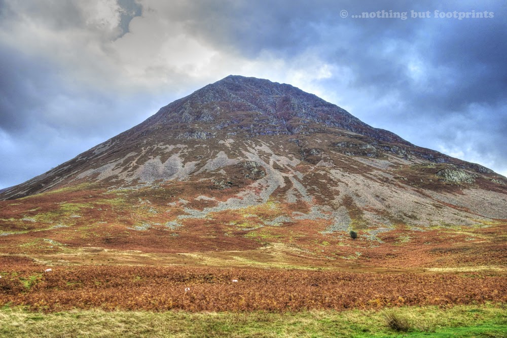
Standing at 2,368 feet (722m), Grasmoor is the highest peak in a group of fells between the villages of Lorton, Braithwaite and Buttermere. From the little car park at Lanthwaite on the eastern shores of Crummock Water, I could see quite clearly what Wainwright had meant when he described this aspect of Grasmoor as a "steep pyramid of rocky ribs". And I was reassured to read "familiarity with this monstrous monolith dispels fear", because from this angle it did look rather intimidating.
As we set off from the car park I looked down the road in the direction of Buttermere, where stormy clouds were gathering on the fell tops. It was blustery but not too windy, at least not at this level, and although the clouds looked ominous, for the time being at least it was dry. Keeping in mind our decision to turn back if conditions deteriorated, we set off.

Our chosen route was to follow the course of the River Liza, along Gasgale Gill between Whiteside and Grasmoor. From this point there are routes directly up to Grasmoor, either around the edge of Grasmoor End or a little further along via Dove Crags. However, both these routes appeared to be very steep and so we'd decided to follow Gasgale Gill all the way up to Coledale Hause.

A little bridge crossed the Liza from where the main path ascended Whiteside, with a narrower path leading into Gasgale Gill. It was still blustery but reasonably sheltered as I stood in the centre of the bridge to take a photograph of the water cascading over the rocks below.

The path along the gill was narrow but well defined at this point and, as I turned to look back at the bridge we'd just crossed, a little shaft of sunlight broke through to shed a patch of light on the fells across the valley.

As we headed up the gill, the path became increasingly treacherous and in one or two places it was necessary to undertake some decidedly risky manoeuvres. On more than one occasion I found that my legs just weren't long enough to stride across a gap in the path, which by this time had risen about 20 feet above the tumbling waters below. It appeared as though heavy rainfall had perhaps washed away some of the path, leaving gaps with loose soil or slippery wet rocks to negotiate. The most anxious moment occurred when I found that the only way across a large gap in the path was to get a foothold on a small rock protruding from the side of the slope, below which was a sheer drop to the rocks below. Tom negotiated this with ease, shouting back to me "Smartly across now. Don't pause in the middle!" This was easier said than done and suddenly I found myself with both feet precariously balanced on the rock, which was beginning to break free from the bank under the strain of holding my weight. I hardly dare move, but knew I had to. Somehow I managed to jump from a position with both feet together and, remarkably, land safely, albeit awkwardly, on the other side. With a shudder I realised that the rock would have held my weight for perhaps only a couple of seconds longer, but I decided not to dwell on it and quickly moved on. Thankfully, the hazardous section was soon over and the walking then became much more relaxed.

The ascent along this route was very gradual and not at all taxing. We were reasonably well sheltered from the wind, and the rain, although constantly threatening, had so far held off. And the previously dodgy path was now very pleasant, running directly by the side of the Liza . Looking back, I could see that we had gained some height even though it didn't particularly feel as if we'd been climbing.

Eventually the path almost levelled out, although we could see that ahead of us it began to climb again as it approached our turning point at Coledale Hause.

In spite of the wind it was quite warm in the gill and so we stopped to replenish our water supply from the clear, pure waters of the Liza before the start of the climb ahead.

Once we had started the ascent to Coledale Hause it began to rain very heavily and the higher we climbed the stronger the wind became until it seemed almost as if we were being power-washed. The rain eased for a time as we reached the plateau of Coledale Hause, enabling me to get a photograph of Grisedale Pike, a mountain we had climbed just over a year ago (and a firm favourite of mine). It was at this point, by the little cairn in the central foreground, that we'd descended for our return to Braithwaite, and this is an alternative route to Grasmoor, which could also include Grisedale Pike and Hopegill Head, for those with plenty of energy.

Our route now led us between Grasmoor and Eel Crag, before turning to climb into the clouds and on to the summit of Grasmoor. From this point onwards, until we began our descent, I was prevented from taking any photographs due to the strength of the wind and rain. On the final ascent I lost count of how many times I was blown off my feet. At one point I took hold of Tom's arm and, much to our amusement, we were both blown over together. Thankfully though, the path was quite wide and I didn't feel in any real danger. The wind assailed us in ferocious gusts and, at the very top, I found that I could avoid being blown over when a gust reached its peak by digging my walking poles in, squatting between them and hanging on for dear life. It must have looked very comical, but at least it kept me upright - some of the time!
We didn't pause on the summit, turning instantly round to descend to the point where we'd left the path between Grasmoor and Eel Crag. Our original intention had been to descend via the ridge known as Lad Hows, but in the dense cloud we had walked past the start of this path and it was only once we'd left the cloud that I realised our error. From where we were standing I could see Lad Hows clearly and I did not fancy walking down there one little bit! It looked like a dangerously steep knife's edge, with a sheer drop at either side - not to be tackled in strong winds for sure.

A quick check on the map confirmed that we were actually standing at the head of Whiteless Edge, looking down to Whiteless Pike, which is a Wainwright of some 2,159 feet. From where we were standing the descent looked almost as precarious as Lad Hows and I was highly apprehensive about attempting it. From this vantage point the path appeared very narrow with a sharp drop at either side and for a while I floundered. As I saw it we had four options. We could descend via the path ahead of us, along Whiteless Edge and over Whiteless Pike, picking up a path back to Lanthwaite through Rannerdale. We could climb part of the way back up Grasmoor and descend via Lad Hows. We could return by the route we had just walked along. Or we could walk back to Coledale Hause, follow the path down to Braithwaite and then get a taxi back to Lanthwaite. For a while I actually favoured the last option, but Tom was all for continuing along Whiteless Edge, pointing out that returning the way we had just walked would mean jumping over those gaps in the path again. Reluctantly, I agreed. My biggest fear at this point was the wind. Looking at the path below I felt certain that being blown over could only lead to certain death. Reminding myself that we could turn back at any point, I tentatively set off down the ridge.

What followed was one of the most enjoyable walks I have ever completed in Lakeland. As I'm slowly starting to realise, some routes can just look a lot worse than they actually are when viewed from even a short distance away. Once we had descended a little way along the ridge we quickly became sheltered from the wind, which now seemed no more than a stiff breeze. And the path which had appeared so narrow and precipitous from above was actually very pleasant indeed. A little way down I turned and looked back. Even from here, I wouldn't fancy that path and yet I'd just walked along it with ease and found it most enjoyable. It would seem that it's all a case of perspective. Maybe even the Lad Hows path isn't so bad, once you're actually on it. I will just have to return, on a better day, to find out for sure.

The further we walked along the Whiteless Pike edge, and the lower we descended, the less our view was impeded by cloud and murk. And what magnificent views they were...across the waters of Crummock Water and beyond to a distant Lowes Water...

...and over to the west, the distant silhouette of the Scafell Range...

Soon the village of Buttermere came into view. As we were admiring the scene the sun broke through the clouds, showering beams of light onto the banks of Crummock Water. It was a magnificent sight and this, combined with the sense of relief I felt that our downwards route had been more enjoyable than hazardous, was exhilarating.

After descending a little further we looked down on Rannerdale Knotts and the little valley of Rannerdale through which our return route to the shores of Crummock Water was clearly visible.

Our path followed the course of the Squat Beck as it wound its way through beautiful Rannerdale. Once a Viking settlement, "Ranner" translates from the old Norse for "shieling (or settlement) of the ravens", although today Rannerdale is best known for the bluebells which carpet the valley in springtime.

On this day, however, Rannerdale was cloaked in autumn shades, the golden bracken providing a mellow contrast to the patches of green grass and the blue-grey waters of Squat Beck and Crummock Water.

The final stage of our walk followed the road back to the car park at Lanthwaite. The wind, whilst still gusty at times, had eased a little and, as it had kept the rain at bay for most of our walk, I was thankful for it. As we walked by the shores of Crummock Water I paused to watch a small flock of grazing Herdwicks. The scene seemed to represent all the loveliest, benign parts of Lakeland and, I thought, provided a pleasing contrast to the drama of the high fells. It was a pleasant and peaceful end to what had been a highly enjoyable and, at times, dramatic walk.

Later that evening, over a glass of Snecklifter, we reviewed the day's walking. As usual, the walk had left us with a yearning for more and further additions to my growing walking "to do" list. Possibly though, this would be our last Lakeland climb of the year....or would it?

Coming soon...We give in to temptation and squeeze one more climb in before the year's end, this time leaving from Keswick for an ascent of Latrigg and Lonscale Fell.
It was a dull and blustery Friday morning as we drove out to Keswick where we spent an enjoyable day around the shops, followed by a pleasant evening in Cockermouth - home to Jenning's Brewery and one of my all-time favourite beers, Snecklifter.
Unfortunately, the weather didn't improve much overnight and the forecast for the rest of the weekend was a bit grim. The need to book accommodation before the availability of a weather forecast with any kind of accuracy is a problem we've encountered a few times. Rain isn't such a problem, but on the fells and mountain tops, wind can be decidedly hazardous or even downright dangerous. On this occasion high winds had been forecast for both of our two available walking days, but as it appeared that Saturday may be a little less windy than Sunday, we decided to at least give it a try. I believe that it's very important, when setting out up a mountain, to be prepared to have to turn back if the conditions become hazardous. The mountain isn't going anywhere. It will be there another day. And so, with this principle in mind, we geared up and set off.
Standing at 2,368 feet (722m), Grasmoor is the highest peak in a group of fells between the villages of Lorton, Braithwaite and Buttermere. From the little car park at Lanthwaite on the eastern shores of Crummock Water, I could see quite clearly what Wainwright had meant when he described this aspect of Grasmoor as a "steep pyramid of rocky ribs". And I was reassured to read "familiarity with this monstrous monolith dispels fear", because from this angle it did look rather intimidating.
Grasmoor
As we set off from the car park I looked down the road in the direction of Buttermere, where stormy clouds were gathering on the fell tops. It was blustery but not too windy, at least not at this level, and although the clouds looked ominous, for the time being at least it was dry. Keeping in mind our decision to turn back if conditions deteriorated, we set off.
Threatening clouds
Our chosen route was to follow the course of the River Liza, along Gasgale Gill between Whiteside and Grasmoor. From this point there are routes directly up to Grasmoor, either around the edge of Grasmoor End or a little further along via Dove Crags. However, both these routes appeared to be very steep and so we'd decided to follow Gasgale Gill all the way up to Coledale Hause.
Gasgale Gill
A little bridge crossed the Liza from where the main path ascended Whiteside, with a narrower path leading into Gasgale Gill. It was still blustery but reasonably sheltered as I stood in the centre of the bridge to take a photograph of the water cascading over the rocks below.
The Liza
The path along the gill was narrow but well defined at this point and, as I turned to look back at the bridge we'd just crossed, a little shaft of sunlight broke through to shed a patch of light on the fells across the valley.
Over the bridge
As we headed up the gill, the path became increasingly treacherous and in one or two places it was necessary to undertake some decidedly risky manoeuvres. On more than one occasion I found that my legs just weren't long enough to stride across a gap in the path, which by this time had risen about 20 feet above the tumbling waters below. It appeared as though heavy rainfall had perhaps washed away some of the path, leaving gaps with loose soil or slippery wet rocks to negotiate. The most anxious moment occurred when I found that the only way across a large gap in the path was to get a foothold on a small rock protruding from the side of the slope, below which was a sheer drop to the rocks below. Tom negotiated this with ease, shouting back to me "Smartly across now. Don't pause in the middle!" This was easier said than done and suddenly I found myself with both feet precariously balanced on the rock, which was beginning to break free from the bank under the strain of holding my weight. I hardly dare move, but knew I had to. Somehow I managed to jump from a position with both feet together and, remarkably, land safely, albeit awkwardly, on the other side. With a shudder I realised that the rock would have held my weight for perhaps only a couple of seconds longer, but I decided not to dwell on it and quickly moved on. Thankfully, the hazardous section was soon over and the walking then became much more relaxed.
A rocky (& sometimes hazardous) path
The ascent along this route was very gradual and not at all taxing. We were reasonably well sheltered from the wind, and the rain, although constantly threatening, had so far held off. And the previously dodgy path was now very pleasant, running directly by the side of the Liza . Looking back, I could see that we had gained some height even though it didn't particularly feel as if we'd been climbing.
The path improves
Eventually the path almost levelled out, although we could see that ahead of us it began to climb again as it approached our turning point at Coledale Hause.
Walking on the level (for now!)
In spite of the wind it was quite warm in the gill and so we stopped to replenish our water supply from the clear, pure waters of the Liza before the start of the climb ahead.
Pure, fresh water
Once we had started the ascent to Coledale Hause it began to rain very heavily and the higher we climbed the stronger the wind became until it seemed almost as if we were being power-washed. The rain eased for a time as we reached the plateau of Coledale Hause, enabling me to get a photograph of Grisedale Pike, a mountain we had climbed just over a year ago (and a firm favourite of mine). It was at this point, by the little cairn in the central foreground, that we'd descended for our return to Braithwaite, and this is an alternative route to Grasmoor, which could also include Grisedale Pike and Hopegill Head, for those with plenty of energy.
Grisedale Pike from Coledale Hause
Our route now led us between Grasmoor and Eel Crag, before turning to climb into the clouds and on to the summit of Grasmoor. From this point onwards, until we began our descent, I was prevented from taking any photographs due to the strength of the wind and rain. On the final ascent I lost count of how many times I was blown off my feet. At one point I took hold of Tom's arm and, much to our amusement, we were both blown over together. Thankfully though, the path was quite wide and I didn't feel in any real danger. The wind assailed us in ferocious gusts and, at the very top, I found that I could avoid being blown over when a gust reached its peak by digging my walking poles in, squatting between them and hanging on for dear life. It must have looked very comical, but at least it kept me upright - some of the time!
We didn't pause on the summit, turning instantly round to descend to the point where we'd left the path between Grasmoor and Eel Crag. Our original intention had been to descend via the ridge known as Lad Hows, but in the dense cloud we had walked past the start of this path and it was only once we'd left the cloud that I realised our error. From where we were standing I could see Lad Hows clearly and I did not fancy walking down there one little bit! It looked like a dangerously steep knife's edge, with a sheer drop at either side - not to be tackled in strong winds for sure.
Lad Hows
A quick check on the map confirmed that we were actually standing at the head of Whiteless Edge, looking down to Whiteless Pike, which is a Wainwright of some 2,159 feet. From where we were standing the descent looked almost as precarious as Lad Hows and I was highly apprehensive about attempting it. From this vantage point the path appeared very narrow with a sharp drop at either side and for a while I floundered. As I saw it we had four options. We could descend via the path ahead of us, along Whiteless Edge and over Whiteless Pike, picking up a path back to Lanthwaite through Rannerdale. We could climb part of the way back up Grasmoor and descend via Lad Hows. We could return by the route we had just walked along. Or we could walk back to Coledale Hause, follow the path down to Braithwaite and then get a taxi back to Lanthwaite. For a while I actually favoured the last option, but Tom was all for continuing along Whiteless Edge, pointing out that returning the way we had just walked would mean jumping over those gaps in the path again. Reluctantly, I agreed. My biggest fear at this point was the wind. Looking at the path below I felt certain that being blown over could only lead to certain death. Reminding myself that we could turn back at any point, I tentatively set off down the ridge.
Whiteless Pike
What followed was one of the most enjoyable walks I have ever completed in Lakeland. As I'm slowly starting to realise, some routes can just look a lot worse than they actually are when viewed from even a short distance away. Once we had descended a little way along the ridge we quickly became sheltered from the wind, which now seemed no more than a stiff breeze. And the path which had appeared so narrow and precipitous from above was actually very pleasant indeed. A little way down I turned and looked back. Even from here, I wouldn't fancy that path and yet I'd just walked along it with ease and found it most enjoyable. It would seem that it's all a case of perspective. Maybe even the Lad Hows path isn't so bad, once you're actually on it. I will just have to return, on a better day, to find out for sure.
A surprisingly pleasant path
The further we walked along the Whiteless Pike edge, and the lower we descended, the less our view was impeded by cloud and murk. And what magnificent views they were...across the waters of Crummock Water and beyond to a distant Lowes Water...
Crummock Water & Lowes Water
...and over to the west, the distant silhouette of the Scafell Range...
Looking over to the Scafells
Soon the village of Buttermere came into view. As we were admiring the scene the sun broke through the clouds, showering beams of light onto the banks of Crummock Water. It was a magnificent sight and this, combined with the sense of relief I felt that our downwards route had been more enjoyable than hazardous, was exhilarating.
Sunlight over Buttermere
After descending a little further we looked down on Rannerdale Knotts and the little valley of Rannerdale through which our return route to the shores of Crummock Water was clearly visible.
Rannerdale Knotts
Our path followed the course of the Squat Beck as it wound its way through beautiful Rannerdale. Once a Viking settlement, "Ranner" translates from the old Norse for "shieling (or settlement) of the ravens", although today Rannerdale is best known for the bluebells which carpet the valley in springtime.
Rannerdale
On this day, however, Rannerdale was cloaked in autumn shades, the golden bracken providing a mellow contrast to the patches of green grass and the blue-grey waters of Squat Beck and Crummock Water.
Autumn in Rannerdale
The final stage of our walk followed the road back to the car park at Lanthwaite. The wind, whilst still gusty at times, had eased a little and, as it had kept the rain at bay for most of our walk, I was thankful for it. As we walked by the shores of Crummock Water I paused to watch a small flock of grazing Herdwicks. The scene seemed to represent all the loveliest, benign parts of Lakeland and, I thought, provided a pleasing contrast to the drama of the high fells. It was a pleasant and peaceful end to what had been a highly enjoyable and, at times, dramatic walk.
Grazing Herdwicks
Later that evening, over a glass of Snecklifter, we reviewed the day's walking. As usual, the walk had left us with a yearning for more and further additions to my growing walking "to do" list. Possibly though, this would be our last Lakeland climb of the year....or would it?
Coming soon...We give in to temptation and squeeze one more climb in before the year's end, this time leaving from Keswick for an ascent of Latrigg and Lonscale Fell.


Comments
Post a Comment