The Dales Way - Day Two - Addingham to Grassington
A gentle rain was falling when I awoke to our second day on the Dales Way. We had left our room curtains open and I could see that the rain would soon pass. It was a little after 5 a.m. Breakfast was almost three hours away, but after an excellent night's sleep I felt refreshed and wide awake. Having made a coffee, I propped myself up in bed and settled back to read my Dales Way guidebook. The previous day we had walked for just over three miles but today the "proper" walking would begin. I wanted to commit as much of the route as possible to memory and to make a mental note of any interesting features along the way. As I soon discovered, there would be plenty of those.
Breakfast was consistent with the high quality of every aspect of our stay at the Crown. I'd decided to avoid filling up each morning with a "full English" and I especially enjoyed the alternative of a soft boiled egg and "soldiers". Over a leisurely breakfast we chatted with the inn's owners about their experiences during the previous year's Tour de France Grand Depart, the many lovely walks which can be had in the area around Addingham and the delights of the Yorkshire Dales in general. We'd had a thoroughly enjoyable, but all too brief stay at the Crown Inn and wouldn't hesitate to return.
As I had predicted, it had stopped raining by the time we set off, at a little after 9 a.m. The sky was overcast and the temperature was a bit on the coolish side, but the conditions were perfect for walking. Having retraced our steps along Addingham's main street, we were soon back to the place where we'd left the trail, descending a flight of steps to return to the banks of the Wharfe. After a short distance the route took us through High Mill, another residential conversion of former mill buildings, although this one didn't seem quite as claustrophobic as Low Mill, which we had passed through the day before. Just beyond High Mill the route entered a caravan park and here I left the path briefly to take a look at the river. I was immediately spotted by a trio of ducks and they began to swim towards me, quacking loudly, obviously expecting a treat. I walked away quickly, so as not to disappoint.

A very clear path led from the caravan park between fields and the river, which by now had narrowed slightly and had become rockier and swifter flowing. There was a hint of drizzle in the air as we passed a lone walker, kitted out in full waterproofs.
"It's alright down here," he commented, "but it's very cold and wet on the higher ground".
We chatted to him for a while and learned that he was returning from an early morning ascent of Simon's Seat, a nearby hill measuring 1,591 feet (485m) which, on a clear day, provides a sweeping view of Wharfedale and the surrounding countryside. I made a mental note to add this to my "To Do" list of walks, although preferably on a clearer day than this. Visibility on the summit, apparently, had been very poor indeed.

As we continued to follow the river we could occasionally see the telltale ripples made by fish topping the surface. The River Wharfe is renowned for its top class fly fishing, having large stocks of wild brown trout and grayling, so it wasn't surprising to pass a lone fisherman standing in the shallows, twitching his line back and forth, seemingly oblivious to our passing.

A short section of road walking led us to a track under the busy A59 Harrogate to Skipton road, emerging into the Bolton Abbey estate. Just before the path passed under the road I spotted a brightly coloured bench onto which someone had painted in white lettering "Bowness 78¾ miles - Ilkley 5¼ miles". Now although maths isn't my strong point, even I can see that adds up to 84 miles. Was the route getting longer? Perhaps because we'd set off the day before, it certainly felt like Ilkley was further away. Not that it mattered. I was still mostly succeeding with my aim of staying in the present moment and relishing every footstep.

After a short walk over the closely cropped grass of the Bolton Abbey parkland we could see the ruins of Bolton Priory ahead of us, by a bend in the river. (Bolton Abbey is the name of the village close to the ruins of Bolton Priory, hence the two different names.) The Augustinian Priory was founded in 1154, suffered heavy losses during a Scottish invasion in 1318 and then was inevitably dissolved by order of Henry VIII in 1538. Today it forms part of the Chatsworth Estate, owned by the Duke of Devonshire, and the Priory, along with the surrounding estate land, is a very popular visitor attraction.

Undoubtedly the most well-known view of Bolton Priory is that taken from the eastern side of the Wharfe, looking over the river and a series of stepping stones. Thankfully, the river can also be crossed by a bridge at this point and, not wanting to push my luck and risk a dunking, I crossed the bridge before stopping to take my own photo of this splendid view. Perhaps it was because it was still reasonably early, or maybe it was because the sun wasn't shining, but I was fortunate that there were very few visitors to encroach upon my shot. Every other time I've visited here the banks of the river were crowded with people. It was a good thing it was quiet, because once I'd knelt down to get the best angle, just as I had the day before, I found myself doing a turtle impersonation as I attempted, and failed, to haul myself back to a standing position under the weight of my rucksack. A couple of ladies sitting on a wall behind me burst into a fit of giggles as, with a very red face, I had to call Tom over to help me up. Once upright again I smiled at them and then set off at a jog, partly to escape their chuckles and partly to mask my embarrassment, as if to say "I'm as fit as a flea really. Just look at me jogging along with this heavy backpack". I don't suppose I fooled anyone, least of all myself, and once round the corner and safely out of sight I stopped to get my breath back.

The Bolton Abbey estate includes all sorts of outdoor activities for children, one of which was a more benign set of "stepping stones", made from cut-down tree trunks set into the grass. They were just calling out to be stepped along and so I happily bounded from one to another displaying a confidence I certainly wouldn't have found on their slippery stone, river-crossing counterparts. People do fall in. I've seen the YouTube videos.

The path led us through some pleasant woodlands which included an activity route for children called the "Welly Walk". There were rope swings, balance beams, tunnels and, my own personal favourite, snakes and ladders which involved clambering up a muddy ladder then sliding back down the equally muddy interior of a length of tubing. I quite fancied a go at that but, realising there was a distinct possibility I'd have become firmly wedged in the tube, I sensibly kept on walking.
The path through the woodland had climbed steadily above the river and presently we descended again to a bridge which took us back across to the other side and the Cavendish Pavilion. Although we'd only been walking for just under two hours this was a welcome sight and we took the opportunity to take a break, enjoying coffee and cake in the pleasant outdoor seating area.

A sudden light rain shower brought people dashing to the pavilion from all directions and in no time at all it had become quite crowded. This was our signal to be putting on our waterproofs and getting on our way again, taking a path which led us into Strid Woods. The guidebook had suggested we could follow any one of the woodland trails through the woods, but we chose to remain close to the river. We hadn't been walking for long when the distinctive smell of wood smoke wafted towards us on the breeze and ahead I could see a strange, ramshackle looking structure with a tarpaulin roof. This was the Bodger Camp, workplace of the Bolton Abbey Bodger, a skilled craftsman who makes woodland products using traditional methods and tools.

We stopped for a while to watch the Bodger at work, turning a piece of wood on his pole lathe, which like almost everything else in his camp was made from branches. Bodgers were often found in woodland areas in the 19th century, usually working their pole lathes to make chair legs and spindles for local chair makers. It is from the name given to these traditional craftsmen that the term "bodge job" is derived.
As we were turning to leave the Bodger Camp a small display of strange little charms caught my eye, a handwritten sign advertising "Lucky Wood Elves". Maybe it was something to do with being out among the trees, in air thickly scented with wood smoke, and a Bodger with an uncanny resemblance to Catweazle, or more likely it was that magic word "lucky", but I had to have me one of those little guys. I handed the Bodger £4 in return for the stumpy end of a stick with a green hat and two eyes painted on it. And that's how I came to be the proud owner of Gordon the Wood Elf. Why Gordon? I have absolutely no idea. That was just the first name to pop into my head as I carried on walking through the woods, smiling happily as I dangled the "elf" from the red piece of cotton threaded through his hat. I can be daft like that, sometimes.

The rainfall had only been light and it had stopped altogether by the time we had returned to the riverbank. The recent shower had cleared the usually popular woodland paths of visitors and it was wonderfully peaceful as we walked through this particularly beautiful section of the trail by the side of the tranquil Wharfe. What lie ahead of us, however, was far from tranquil, although undeniably beautiful.

The Strid is considered to be one of the most dangerous natural features in the world. In fact, on a list entitled "The 10 most naturally dangerous places in the world" it's ranked as Number One. At first sight it doesn't look particularly lethal. It just looks like a little waterfall passing between moss-covered rocks. But that pretty little waterfall is actually the entirety of the River Wharfe, which just a short distance upstream is a reasonably wide river. What happens at The Strid is that the whole river turns onto its side to pass through a narrow channel between the rocks. The depth of this channel is unknown, but no one who has fallen in here has lived to tell the tale. It has a 100% mortality rate. And worse still, many of those who have fallen to their deaths here have never been found. It's safe to assume there's a mighty cavern down there with some pretty grisly contents. Many of the deaths here occurred when someone had attempted to jump over what seems to be a reasonably narrow gap. It looks doable. It isn't! Those rocks are treacherously slippery.
I crept as close to this murderous beauty spot as I dare, took a couple of photographs, and then sheepishly edged away.

Once safely away from the lethal beauty of The Strid and its surrounding woodlands we continued alongside a calmer stretch of river until we had reached an attractive, crenellated bridge which is actually an aqueduct, containing a hidden pipe which carries water to West Yorkshire from the reservoirs of Upper Nidderdale.

We crossed the bridge and followed the path on the opposite side of the river until it emerged into the car park at Barden Bridge. This large, grassy car park contained a pay station booth and just one parked car. Everyone else, it seems, had parked for free by the side of the river and initially I felt a bit sorry for the person working all on their own inside the little glass-sided booth. When you think about it though, it might not be such a bad job after all, working in such a lovely setting with very little to do. Time alone to catch up with some reading, listen to some music or simply contemplate the meaning of life. Just the occasional need to smile and say "Good morning. Four pounds please" (or whatever it costs). Even then, I expect it's not an entirely stress-free occupation though. Someone is bound to growl "HOW much?"
The route of the Dales Way continued northwards from Barden Bridge, but here we took a slight detour of half a mile or so, ascending the steep lane to the delightful ruin of Barden Tower.
Built in the 15th century, Barden Tower was a former keeper's lodge serving the nearby old hunting forest. It was remodelled to a town house by Henry, the 10th Lord Clifford, who preferred spending his time here to his main residence at nearby Skipton Castle. After his death the tower fell into disuse but was restored by Lady Anne Clifford in 1659. Today just the outer shell of Barden Tower remains and the interior isn't accessible to visitors, due to the dangers of falling masonry. I've driven past here several times but I'd never had the opportunity to take a closer look, so it was certainly worth the short detour, which added just under a mile onto our day's walking.

After retracing our steps downhill and back to Barden Bridge we continued to follow the riverside path which eventually led us into Haugh Wood. Here the river was especially picturesque with the rocks and whitewater rapids that make this stretch of the Wharfe very popular with canoeists.

Leaving Haugh Wood, we continued along the riverside, heading for the village of Appletreewick, which is actually pronounced "Ap'trick", possibly qualifying it for the title "Village with the biggest number of redundant letters". Our intention was to visit one of Appletreewick's two pubs for a drink and a sandwich. I already knew that there was a path from the riverbank which would take us off the Dales Way and up to the village, and as soon as I spotted a likely looking track we followed it in the direction of the New Inn. At the end of the track we were met with a padlocked metal gate, which surprised me as I'd been certain that we were following a public right of way. Clearly we'd taken the wrong path. We'd trespassed! I turned to look back down the hill to the river. Now we could either retrace our steps, thereby trespassing a second time and adding extra distance to our route, or we could make an attempt on the gate. Effortlessly I leapt over it, landing catlike at the other side, arms extended in a gymnastic flourish. Who am I kidding? I clambered up, one rung at a time, then half jumped, half fell, hitting the ground at the other side like a sack of potatoes. On this side of the gate we discovered a large sign: "Private land. This is NOT the footpath to the river". That's when I remembered what I'd read in my guidebook that morning. The public footpath to the river is actually about half a mile or so further along, passing by the side of a campsite. Sheepishly I looked around for signs of an angry landowner before scurrying along the lane to the pub's lovely roadside beer garden. Convinced that a pub full of people had just witnessed our trespassing and one of them was even now making a phone call to the farmer, I sent Tom into the pub to buy beer and sandwiches whilst I gratefully removed my rucksack and took a seat at a vacant table. In actual fact, all the tables were vacant which I found a bit surprising for a Sunday afternoon in June. It was such a delightful place to take a break.

Eventually Tom emerged from the pub with our beers and a rather startled expression on his face. I began to worry. Were we really in trouble for trespassing? And where were my sandwiches?
"The food will be out in a few minutes," he said, knowing where my priorities lie. "You're not going to believe what just happened in there," he added.
He went on to explain that he'd been standing at the bar, patiently awaiting his turn to be served, when he'd felt a light tap upon his shoulder and a vaguely familiar voice had asked "How are the socks?" Of all the places we could have visited in the entire Yorkshire Dales, it turns out we had picked the one frequented by the over-zealous sock salesman from Ilkley (see Day One of my Dales Way blog). Coincidence? Or service above and beyond the call of duty? We were still chuckling when our sandwiches arrived a few minutes later.
It was tempting to spend a while longer in the New Inn's beautiful beer garden but time was ticking on and, not being in the market for any extra socks, we finished our snack, drank up and headed back to the river, this time following the correct path, by the side of the campsite. The following section of the River Wharfe was especially serene and peaceful and the only other living being we passed was a solitary cow, lazily drinking from the opposite bank.

The landscape was now becoming progressively more Dales-like, with steeper hills, drystone walls and barns. The afternoon was still overcast and cool but thankfully it had remained dry and it was an absolute delight to just amble along in such a wonderful setting, all the while getting closer to our evening's destination at Grassington.

With the exception of the area around the Cavendish Pavilion, most of our walk had been very quiet indeed and it had rather surprised me to find so few people were out and about. That situation changed, however, when we reached the village of Burnsall which was quite the hive of activity with walkers, cyclists and day-trippers. Our route passed directly in front of the Red Lion Inn where we noticed some vacant tables by the door, with a view across to Burnsall's ancient packhorse bridge. We paused for just a second before both repeating in unison our favoured mantra when passing a pub en route: "It would be rude not to". We only had the one though. It was, at best, an average beer (Theakston's Bitter) and time was pressing on.

The riverside area just north of Burnsall, it seems, is a popular place for picnics. We passed a few families enjoying this pretty section of riverbank and, a bit further along, a group of teenagers with a barbeque. One of them seemed rather interested in coaxing a large cow to take a handful of offered grass and I couldn't resist calling out "That'll never fit on your barbie". It wasn't the best joke in the world, and I hadn't expected hoots of laughter. A titter or two, perhaps. But instead I was met with a stony silence and a few cold teenage stares as I scurried up a steep knoll and out of sight.
On the other side of the small hill we were met with a very picturesque scene. We had reached Loup Scar. This small limestone gorge is a popular place for both wild swimming and rock climbing. And it also has a darker, grisly history. It was here in 1766 that Tom Lee (blacksmith and landlord of the Blue Anchor Inn, Grassington) dumped the body of Doctor Petty, Grassington's village doctor. As well as his main, respectable occupations, Tom Lee also indulged in a spot of highway robbery on the side. On one occasion, whilst engaged in this criminal activity, Lee had managed to get himself shot and had sought out the services of Dr Petty. The kindly doctor treated Lee's wounds freely, without turning him over to the authorities, which Lee promptly repaid by silencing him for good. Lee was eventually tried for murder, found guilty and hanged at York on 25th July 1768, thereafter his body returned to the scene of his crime in nearby Grass Wood, where it swung and rotted in a gibbet for some years to follow. It certainly isn't a tale to dwell upon in such a delightful setting as Loup Scar.

After passing through a pleasant short section of woodland we reached Hebden Swing Bridge, which I suspect is so-called because it can swing alarmingly from side to side in windy conditions. Faced with a choice of stepping stones or the bridge, we chose the bridge which was somewhat disappointingly steady on this occasion.

As we crossed over, one at a time, we both paused in the centre and gave it a little swing, enjoying the gentle swaying motion with the confidence of being there in calm weather. I couldn't help but wonder what it would be like to cross over in a gale. Great fun possibly, dependent upon the number of beers consumed at the Red Lion, of course.

The other side of the river brought us to a pleasant section of path, lined with mature Horse Chestnut trees and a distinct park-like feel. Here we were passed by several joggers and dog-walkers as we drew closer to Grassington, making this the busiest section of the day's walk.

The final section of our day's route passed by Linton Falls, a stunning area of rapids and waterfalls created by the Mid Craven Fault, a geological shifting of the limestone which crosses the River Wharfe at this point. A pedestrian bridge provided me with an excellent vantage point from which to photograph the former mill buildings overlooking the falls.

From the other side of the bridge we could see Grassington in the distance, beyond a series of weirs which until the 1950s harnessed the power of the Wharfe to provide hydro-electricity for the village. Today this power is gathered by a twin Archimedes screw generator which provides enough power for Grassington with enough spare to contribute to the National Grid. Power and beauty combined in one truly lovely scene.

It was a little after 5 p.m. as we walked into the village and the streets were almost deserted, in spite of our arrival coinciding with the start of the 35th Annual Grassington Festival. This popular event features live music, theatre, dance, comedy and film, along with visual art displays and workshops. It attracts some big names which this year was to include the likes of Pam Ayres and "Pub Landlord" Al Murray. So where was everybody? The only sign of activity as we approached our evening's accommodation at The Black Horse Hotel was a few people clustered inside a large gazebo in the centre of the village square.
Even more surprising than the lack of people on the streets was the discovery that, at the time of checking in, we were the hotel's only residents for the night. Later that evening a lone cyclist turned up but otherwise the place was all but empty. Over a rather disappointing evening meal we briefly considered attending a performance by the Reduced Shakespeare Company which was taking place that evening in the Town Hall. Perhaps that was where everyone had gone? In the end though we decided to relax in the hotel bar over a few pints of the highly delicious, but somewhat pricey Grassington Bitter. It was just nice to sit back, rest our feet and contemplate the day's walk. And what a walk it had been. In total we had covered just over 16 miles, including our diversions to visit Barden Tower and the New Inn at Appletreewick. There had been so much beauty and interest every step along the way and, as I sat sipping on my beer, I realised that this day's walking alone must surely rank as one of my all-time favourites. And there was more to come. Because the next day we would briefly leave the River Wharfe and take a higher route through a truly spectacular Dales landscape.

Total distance walked: 16.12 miles
Total walking time: 8 hours 25 minutes (including breaks)
Next time... Our route takes us away from the River Wharfe as we cross over the head of Conistone Dib, over to Kettlewell rejoining the river to pass by Buckden and on to our night's base at Hubberholme. Along the way we are treated to arguably the loveliest view on the entire Dales Way and most certainly the finest ale.
Breakfast was consistent with the high quality of every aspect of our stay at the Crown. I'd decided to avoid filling up each morning with a "full English" and I especially enjoyed the alternative of a soft boiled egg and "soldiers". Over a leisurely breakfast we chatted with the inn's owners about their experiences during the previous year's Tour de France Grand Depart, the many lovely walks which can be had in the area around Addingham and the delights of the Yorkshire Dales in general. We'd had a thoroughly enjoyable, but all too brief stay at the Crown Inn and wouldn't hesitate to return.
As I had predicted, it had stopped raining by the time we set off, at a little after 9 a.m. The sky was overcast and the temperature was a bit on the coolish side, but the conditions were perfect for walking. Having retraced our steps along Addingham's main street, we were soon back to the place where we'd left the trail, descending a flight of steps to return to the banks of the Wharfe. After a short distance the route took us through High Mill, another residential conversion of former mill buildings, although this one didn't seem quite as claustrophobic as Low Mill, which we had passed through the day before. Just beyond High Mill the route entered a caravan park and here I left the path briefly to take a look at the river. I was immediately spotted by a trio of ducks and they began to swim towards me, quacking loudly, obviously expecting a treat. I walked away quickly, so as not to disappoint.

Ducks on the Wharfe....about to be disappointed
A very clear path led from the caravan park between fields and the river, which by now had narrowed slightly and had become rockier and swifter flowing. There was a hint of drizzle in the air as we passed a lone walker, kitted out in full waterproofs.
"It's alright down here," he commented, "but it's very cold and wet on the higher ground".
We chatted to him for a while and learned that he was returning from an early morning ascent of Simon's Seat, a nearby hill measuring 1,591 feet (485m) which, on a clear day, provides a sweeping view of Wharfedale and the surrounding countryside. I made a mental note to add this to my "To Do" list of walks, although preferably on a clearer day than this. Visibility on the summit, apparently, had been very poor indeed.

Riverside path
As we continued to follow the river we could occasionally see the telltale ripples made by fish topping the surface. The River Wharfe is renowned for its top class fly fishing, having large stocks of wild brown trout and grayling, so it wasn't surprising to pass a lone fisherman standing in the shallows, twitching his line back and forth, seemingly oblivious to our passing.

Fly fishing
A short section of road walking led us to a track under the busy A59 Harrogate to Skipton road, emerging into the Bolton Abbey estate. Just before the path passed under the road I spotted a brightly coloured bench onto which someone had painted in white lettering "Bowness 78¾ miles - Ilkley 5¼ miles". Now although maths isn't my strong point, even I can see that adds up to 84 miles. Was the route getting longer? Perhaps because we'd set off the day before, it certainly felt like Ilkley was further away. Not that it mattered. I was still mostly succeeding with my aim of staying in the present moment and relishing every footstep.

84 miles?
After a short walk over the closely cropped grass of the Bolton Abbey parkland we could see the ruins of Bolton Priory ahead of us, by a bend in the river. (Bolton Abbey is the name of the village close to the ruins of Bolton Priory, hence the two different names.) The Augustinian Priory was founded in 1154, suffered heavy losses during a Scottish invasion in 1318 and then was inevitably dissolved by order of Henry VIII in 1538. Today it forms part of the Chatsworth Estate, owned by the Duke of Devonshire, and the Priory, along with the surrounding estate land, is a very popular visitor attraction.

Approaching Bolton Priory
Undoubtedly the most well-known view of Bolton Priory is that taken from the eastern side of the Wharfe, looking over the river and a series of stepping stones. Thankfully, the river can also be crossed by a bridge at this point and, not wanting to push my luck and risk a dunking, I crossed the bridge before stopping to take my own photo of this splendid view. Perhaps it was because it was still reasonably early, or maybe it was because the sun wasn't shining, but I was fortunate that there were very few visitors to encroach upon my shot. Every other time I've visited here the banks of the river were crowded with people. It was a good thing it was quiet, because once I'd knelt down to get the best angle, just as I had the day before, I found myself doing a turtle impersonation as I attempted, and failed, to haul myself back to a standing position under the weight of my rucksack. A couple of ladies sitting on a wall behind me burst into a fit of giggles as, with a very red face, I had to call Tom over to help me up. Once upright again I smiled at them and then set off at a jog, partly to escape their chuckles and partly to mask my embarrassment, as if to say "I'm as fit as a flea really. Just look at me jogging along with this heavy backpack". I don't suppose I fooled anyone, least of all myself, and once round the corner and safely out of sight I stopped to get my breath back.

Bolton Priory and the stepping stones
The Bolton Abbey estate includes all sorts of outdoor activities for children, one of which was a more benign set of "stepping stones", made from cut-down tree trunks set into the grass. They were just calling out to be stepped along and so I happily bounded from one to another displaying a confidence I certainly wouldn't have found on their slippery stone, river-crossing counterparts. People do fall in. I've seen the YouTube videos.
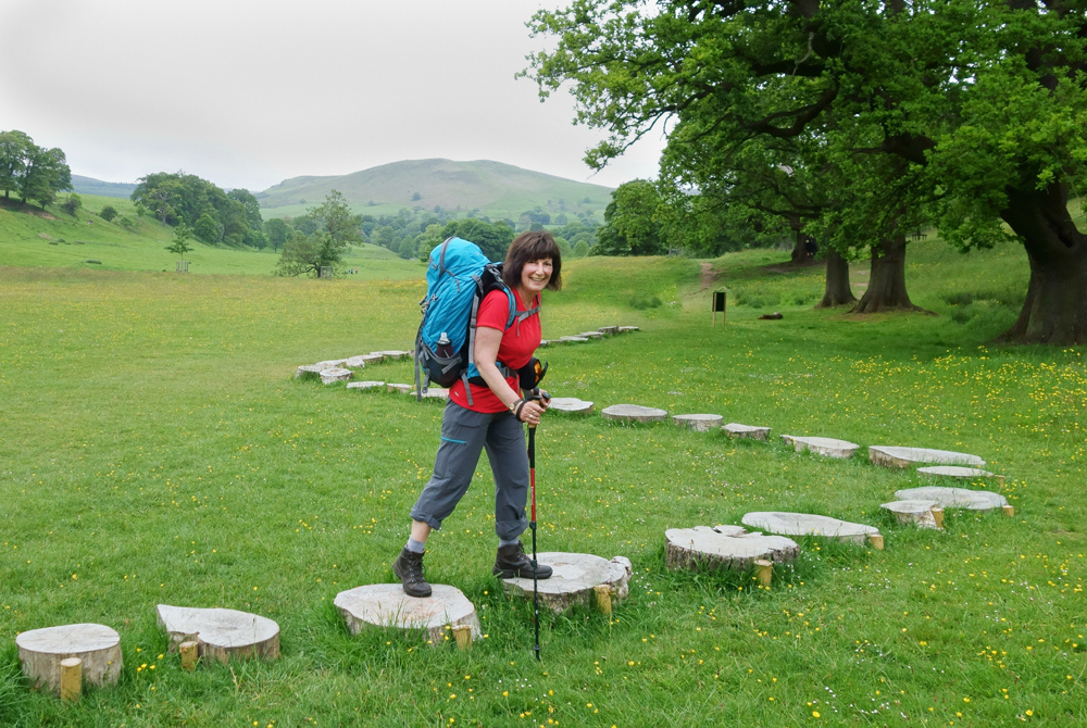
A less hazardous set of "stepping stones"
The path led us through some pleasant woodlands which included an activity route for children called the "Welly Walk". There were rope swings, balance beams, tunnels and, my own personal favourite, snakes and ladders which involved clambering up a muddy ladder then sliding back down the equally muddy interior of a length of tubing. I quite fancied a go at that but, realising there was a distinct possibility I'd have become firmly wedged in the tube, I sensibly kept on walking.
The path through the woodland had climbed steadily above the river and presently we descended again to a bridge which took us back across to the other side and the Cavendish Pavilion. Although we'd only been walking for just under two hours this was a welcome sight and we took the opportunity to take a break, enjoying coffee and cake in the pleasant outdoor seating area.

The Cavendish Pavilion
A sudden light rain shower brought people dashing to the pavilion from all directions and in no time at all it had become quite crowded. This was our signal to be putting on our waterproofs and getting on our way again, taking a path which led us into Strid Woods. The guidebook had suggested we could follow any one of the woodland trails through the woods, but we chose to remain close to the river. We hadn't been walking for long when the distinctive smell of wood smoke wafted towards us on the breeze and ahead I could see a strange, ramshackle looking structure with a tarpaulin roof. This was the Bodger Camp, workplace of the Bolton Abbey Bodger, a skilled craftsman who makes woodland products using traditional methods and tools.

The Bodger Camp
We stopped for a while to watch the Bodger at work, turning a piece of wood on his pole lathe, which like almost everything else in his camp was made from branches. Bodgers were often found in woodland areas in the 19th century, usually working their pole lathes to make chair legs and spindles for local chair makers. It is from the name given to these traditional craftsmen that the term "bodge job" is derived.
As we were turning to leave the Bodger Camp a small display of strange little charms caught my eye, a handwritten sign advertising "Lucky Wood Elves". Maybe it was something to do with being out among the trees, in air thickly scented with wood smoke, and a Bodger with an uncanny resemblance to Catweazle, or more likely it was that magic word "lucky", but I had to have me one of those little guys. I handed the Bodger £4 in return for the stumpy end of a stick with a green hat and two eyes painted on it. And that's how I came to be the proud owner of Gordon the Wood Elf. Why Gordon? I have absolutely no idea. That was just the first name to pop into my head as I carried on walking through the woods, smiling happily as I dangled the "elf" from the red piece of cotton threaded through his hat. I can be daft like that, sometimes.

Introducing...Gordon. He's a lucky elf (allegedly)

In Strid Wood
The Strid is considered to be one of the most dangerous natural features in the world. In fact, on a list entitled "The 10 most naturally dangerous places in the world" it's ranked as Number One. At first sight it doesn't look particularly lethal. It just looks like a little waterfall passing between moss-covered rocks. But that pretty little waterfall is actually the entirety of the River Wharfe, which just a short distance upstream is a reasonably wide river. What happens at The Strid is that the whole river turns onto its side to pass through a narrow channel between the rocks. The depth of this channel is unknown, but no one who has fallen in here has lived to tell the tale. It has a 100% mortality rate. And worse still, many of those who have fallen to their deaths here have never been found. It's safe to assume there's a mighty cavern down there with some pretty grisly contents. Many of the deaths here occurred when someone had attempted to jump over what seems to be a reasonably narrow gap. It looks doable. It isn't! Those rocks are treacherously slippery.
I crept as close to this murderous beauty spot as I dare, took a couple of photographs, and then sheepishly edged away.

The Strid
Once safely away from the lethal beauty of The Strid and its surrounding woodlands we continued alongside a calmer stretch of river until we had reached an attractive, crenellated bridge which is actually an aqueduct, containing a hidden pipe which carries water to West Yorkshire from the reservoirs of Upper Nidderdale.

The Aqueduct
We crossed the bridge and followed the path on the opposite side of the river until it emerged into the car park at Barden Bridge. This large, grassy car park contained a pay station booth and just one parked car. Everyone else, it seems, had parked for free by the side of the river and initially I felt a bit sorry for the person working all on their own inside the little glass-sided booth. When you think about it though, it might not be such a bad job after all, working in such a lovely setting with very little to do. Time alone to catch up with some reading, listen to some music or simply contemplate the meaning of life. Just the occasional need to smile and say "Good morning. Four pounds please" (or whatever it costs). Even then, I expect it's not an entirely stress-free occupation though. Someone is bound to growl "HOW much?"
The route of the Dales Way continued northwards from Barden Bridge, but here we took a slight detour of half a mile or so, ascending the steep lane to the delightful ruin of Barden Tower.
Built in the 15th century, Barden Tower was a former keeper's lodge serving the nearby old hunting forest. It was remodelled to a town house by Henry, the 10th Lord Clifford, who preferred spending his time here to his main residence at nearby Skipton Castle. After his death the tower fell into disuse but was restored by Lady Anne Clifford in 1659. Today just the outer shell of Barden Tower remains and the interior isn't accessible to visitors, due to the dangers of falling masonry. I've driven past here several times but I'd never had the opportunity to take a closer look, so it was certainly worth the short detour, which added just under a mile onto our day's walking.

Barden Tower
After retracing our steps downhill and back to Barden Bridge we continued to follow the riverside path which eventually led us into Haugh Wood. Here the river was especially picturesque with the rocks and whitewater rapids that make this stretch of the Wharfe very popular with canoeists.

The rapids at Haugh Wood
Leaving Haugh Wood, we continued along the riverside, heading for the village of Appletreewick, which is actually pronounced "Ap'trick", possibly qualifying it for the title "Village with the biggest number of redundant letters". Our intention was to visit one of Appletreewick's two pubs for a drink and a sandwich. I already knew that there was a path from the riverbank which would take us off the Dales Way and up to the village, and as soon as I spotted a likely looking track we followed it in the direction of the New Inn. At the end of the track we were met with a padlocked metal gate, which surprised me as I'd been certain that we were following a public right of way. Clearly we'd taken the wrong path. We'd trespassed! I turned to look back down the hill to the river. Now we could either retrace our steps, thereby trespassing a second time and adding extra distance to our route, or we could make an attempt on the gate. Effortlessly I leapt over it, landing catlike at the other side, arms extended in a gymnastic flourish. Who am I kidding? I clambered up, one rung at a time, then half jumped, half fell, hitting the ground at the other side like a sack of potatoes. On this side of the gate we discovered a large sign: "Private land. This is NOT the footpath to the river". That's when I remembered what I'd read in my guidebook that morning. The public footpath to the river is actually about half a mile or so further along, passing by the side of a campsite. Sheepishly I looked around for signs of an angry landowner before scurrying along the lane to the pub's lovely roadside beer garden. Convinced that a pub full of people had just witnessed our trespassing and one of them was even now making a phone call to the farmer, I sent Tom into the pub to buy beer and sandwiches whilst I gratefully removed my rucksack and took a seat at a vacant table. In actual fact, all the tables were vacant which I found a bit surprising for a Sunday afternoon in June. It was such a delightful place to take a break.

Beer garden with a view
Eventually Tom emerged from the pub with our beers and a rather startled expression on his face. I began to worry. Were we really in trouble for trespassing? And where were my sandwiches?
"The food will be out in a few minutes," he said, knowing where my priorities lie. "You're not going to believe what just happened in there," he added.
He went on to explain that he'd been standing at the bar, patiently awaiting his turn to be served, when he'd felt a light tap upon his shoulder and a vaguely familiar voice had asked "How are the socks?" Of all the places we could have visited in the entire Yorkshire Dales, it turns out we had picked the one frequented by the over-zealous sock salesman from Ilkley (see Day One of my Dales Way blog). Coincidence? Or service above and beyond the call of duty? We were still chuckling when our sandwiches arrived a few minutes later.
It was tempting to spend a while longer in the New Inn's beautiful beer garden but time was ticking on and, not being in the market for any extra socks, we finished our snack, drank up and headed back to the river, this time following the correct path, by the side of the campsite. The following section of the River Wharfe was especially serene and peaceful and the only other living being we passed was a solitary cow, lazily drinking from the opposite bank.

A tranquil scene
The landscape was now becoming progressively more Dales-like, with steeper hills, drystone walls and barns. The afternoon was still overcast and cool but thankfully it had remained dry and it was an absolute delight to just amble along in such a wonderful setting, all the while getting closer to our evening's destination at Grassington.

A typical Dales landscape
With the exception of the area around the Cavendish Pavilion, most of our walk had been very quiet indeed and it had rather surprised me to find so few people were out and about. That situation changed, however, when we reached the village of Burnsall which was quite the hive of activity with walkers, cyclists and day-trippers. Our route passed directly in front of the Red Lion Inn where we noticed some vacant tables by the door, with a view across to Burnsall's ancient packhorse bridge. We paused for just a second before both repeating in unison our favoured mantra when passing a pub en route: "It would be rude not to". We only had the one though. It was, at best, an average beer (Theakston's Bitter) and time was pressing on.

The bridge at Burnsall
The riverside area just north of Burnsall, it seems, is a popular place for picnics. We passed a few families enjoying this pretty section of riverbank and, a bit further along, a group of teenagers with a barbeque. One of them seemed rather interested in coaxing a large cow to take a handful of offered grass and I couldn't resist calling out "That'll never fit on your barbie". It wasn't the best joke in the world, and I hadn't expected hoots of laughter. A titter or two, perhaps. But instead I was met with a stony silence and a few cold teenage stares as I scurried up a steep knoll and out of sight.
On the other side of the small hill we were met with a very picturesque scene. We had reached Loup Scar. This small limestone gorge is a popular place for both wild swimming and rock climbing. And it also has a darker, grisly history. It was here in 1766 that Tom Lee (blacksmith and landlord of the Blue Anchor Inn, Grassington) dumped the body of Doctor Petty, Grassington's village doctor. As well as his main, respectable occupations, Tom Lee also indulged in a spot of highway robbery on the side. On one occasion, whilst engaged in this criminal activity, Lee had managed to get himself shot and had sought out the services of Dr Petty. The kindly doctor treated Lee's wounds freely, without turning him over to the authorities, which Lee promptly repaid by silencing him for good. Lee was eventually tried for murder, found guilty and hanged at York on 25th July 1768, thereafter his body returned to the scene of his crime in nearby Grass Wood, where it swung and rotted in a gibbet for some years to follow. It certainly isn't a tale to dwell upon in such a delightful setting as Loup Scar.

Loup Scar
After passing through a pleasant short section of woodland we reached Hebden Swing Bridge, which I suspect is so-called because it can swing alarmingly from side to side in windy conditions. Faced with a choice of stepping stones or the bridge, we chose the bridge which was somewhat disappointingly steady on this occasion.

Hebden Swing Bridge - and stepping stones
As we crossed over, one at a time, we both paused in the centre and gave it a little swing, enjoying the gentle swaying motion with the confidence of being there in calm weather. I couldn't help but wonder what it would be like to cross over in a gale. Great fun possibly, dependent upon the number of beers consumed at the Red Lion, of course.

One at a time...swinging the swing bridge
The other side of the river brought us to a pleasant section of path, lined with mature Horse Chestnut trees and a distinct park-like feel. Here we were passed by several joggers and dog-walkers as we drew closer to Grassington, making this the busiest section of the day's walk.

An avenue of Horse Chestnuts
The final section of our day's route passed by Linton Falls, a stunning area of rapids and waterfalls created by the Mid Craven Fault, a geological shifting of the limestone which crosses the River Wharfe at this point. A pedestrian bridge provided me with an excellent vantage point from which to photograph the former mill buildings overlooking the falls.

Linton Falls
From the other side of the bridge we could see Grassington in the distance, beyond a series of weirs which until the 1950s harnessed the power of the Wharfe to provide hydro-electricity for the village. Today this power is gathered by a twin Archimedes screw generator which provides enough power for Grassington with enough spare to contribute to the National Grid. Power and beauty combined in one truly lovely scene.

The weirs at Linton Falls
It was a little after 5 p.m. as we walked into the village and the streets were almost deserted, in spite of our arrival coinciding with the start of the 35th Annual Grassington Festival. This popular event features live music, theatre, dance, comedy and film, along with visual art displays and workshops. It attracts some big names which this year was to include the likes of Pam Ayres and "Pub Landlord" Al Murray. So where was everybody? The only sign of activity as we approached our evening's accommodation at The Black Horse Hotel was a few people clustered inside a large gazebo in the centre of the village square.
Even more surprising than the lack of people on the streets was the discovery that, at the time of checking in, we were the hotel's only residents for the night. Later that evening a lone cyclist turned up but otherwise the place was all but empty. Over a rather disappointing evening meal we briefly considered attending a performance by the Reduced Shakespeare Company which was taking place that evening in the Town Hall. Perhaps that was where everyone had gone? In the end though we decided to relax in the hotel bar over a few pints of the highly delicious, but somewhat pricey Grassington Bitter. It was just nice to sit back, rest our feet and contemplate the day's walk. And what a walk it had been. In total we had covered just over 16 miles, including our diversions to visit Barden Tower and the New Inn at Appletreewick. There had been so much beauty and interest every step along the way and, as I sat sipping on my beer, I realised that this day's walking alone must surely rank as one of my all-time favourites. And there was more to come. Because the next day we would briefly leave the River Wharfe and take a higher route through a truly spectacular Dales landscape.

The Black Horse Hotel
Total distance walked: 16.12 miles
Total walking time: 8 hours 25 minutes (including breaks)
Next time... Our route takes us away from the River Wharfe as we cross over the head of Conistone Dib, over to Kettlewell rejoining the river to pass by Buckden and on to our night's base at Hubberholme. Along the way we are treated to arguably the loveliest view on the entire Dales Way and most certainly the finest ale.


Comments
Post a Comment