The Dales Way - Day Four - Hubberholme to Ribblehead
Daylight was just breaking as I awoke to our fourth day on the Dales Way. My bed was directly below a skylight window onto which a steady rainfall was pattering. The sound was deeply relaxing and I lay for a while with my eyes closed, just listening. Presently the rain eased and a chorus of birdsong prompted me to get up and make a coffee so that I could study my guidebook and commit the day's route to memory.
Breakfast at The George was served from 7.30 a.m., which was the earliest time offered by any of the accommodation we stayed at on the Dales Way. We appreciated the early start, although perhaps on this of all days it wasn't quite so important. There was only just over 12 miles to walk to our next destination and nothing to distract us along the way. Between Hubberholme and Ribblehead is something of a wilderness as far as pubs, cafes or shops are concerned. Which was just as well, seeing as we'd somewhat overindulged the day before.
At least two other groups of Dales Way walkers had been staying at The George, but we were the only ones to sit down to breakfast so early. From overheard conversations the night before I knew that at least one of the groups was heading for the same destination as us and I wanted to get a head start to avoid us all setting off at the same time. It's not that we're anti-social or anything like that. It's just that I prefer to walk with the feeling that we're the only ones around. And to be able to make the inevitable calls of nature without wondering how soon it will be before someone catches us up!
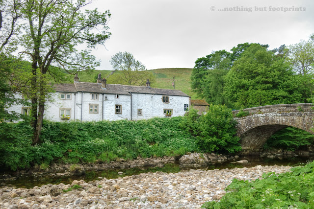
After a highly enjoyable breakfast we chatted to Ed the landlord and collected the packed lunches we'd ordered from him the night before.
"Come back and see us again, won't you," he said, as he waved us off on our way. We promised we'd return to spend at least a couple of nights in his delightful inn and to enjoy some of the excellent walking which can be undertaken right from the doorstep. Of all the places we stayed on the Dales Way, the George was the one I most regretted having to leave so soon.
Once across the river we took one last look at The George before walking a few yards along the lane to rejoin the Dales Way as it passed behind the Norman church of Saint Michael and All Angels. On a future visit I may have a look inside this church, which I understand still has its original Tudor roof loft. This is something of a rare survival as most of these architectural features were destroyed by Cromwell's puritans during the English Civil War.

Behind the church our route climbed upwards for a while, following a somewhat eroded path before returning to the banks of the Wharfe, which by now was little more than a stream tumbling between the rocks. We were now heading into Langstrothdale, one of the most beautiful sections of the entire Dales Way.

The earlier rain had moved away and the sun had begun to shine as we walked along with the river to our left and a series of wildflower meadows to our right. It was a little after 8.30 and we relaxed our pace, realising that if we walked too quickly we would reach our next destination way too soon. This was a part of the Dales with which we were unfamiliar, so the opportunity to take our time and enjoy the scenery was very welcome indeed.

And what scenery! The sunshine was pleasantly warm accompanied by a gentle breeze and we dawdled along as the wonders of Langstrothdale unfolded before us. Every few steps revealed an increasingly beautiful scene. I felt like I was in paradise.

After passing through a farm at the hamlet of Yockenthwaite our route led us directly by a little stone circle. Measuring 25 feet in diameter and made up of 20 small stones set almost edge to edge, the Yockenthwaite Stone Circle is most likely the remains of a Bronze Age burial mound. This would have been the place where an important local chieftain was buried and in the centre it was just possible to make out a small mound marking the actual place of burial.

Shortly after passing the stone circle we crossed over the river at Deepdale and continued to follow its ever diminishing course upstream. As we walked along I regularly glanced over my shoulder, to check if any of the other walkers were catching us up, but it seemed that we still had this delightfully peaceful dale all to ourselves. A narrow lane followed the river on the opposite bank and a lone cyclist sped by, otherwise the only signs of life were the sheep dotted around the hillsides.

A little further upstream and the riverbed dried up as the Wharfe disappeared underground for a short section. It was clear though, from the width of the rocky bed between the banks, that when in full spate it must sometimes also flow above the ground.

Still, it seemed, we had the beautiful valley of Langstrothdale all to ourselves, as the river resurfaced, cascading over rocks in delightful little waterfalls and occasionally forming inviting deep pools. We slowed to a dawdle, savouring every footstep.

At the small settlement of Beckermonds we crossed back over the river again and turned to follow a narrow lane uphill to meet with a road. I was sorry to be leaving Langstrothdale as now, for the next couple of miles or so, the route of the Dales Way followed the course of the road to Oughtershaw.

As we entered the village of Oughtershaw we passed an intriguing building which looked a bit like a mausoleum. This, it turned out, had actually been a school and chapel designed by John Ruskin in 1856 for the Wood family of nearby Oughtershaw Hall. The sun had temporarily disappeared behind the increasing cloud cover as we passed by and this now derelict building looked rather sad and gloomy I thought, as indeed did all of Oughtershaw. After the beautiful scenery we'd enjoyed just a short time before I was rather glad to pass through Oughtershaw and get off the road again.

Now our route was to take us through a wide valley, for the first part following a farm track for a mile or so. We were heading for the higher ground at the end of the valley where we'd meet up with the Cam High Road, a former military road constructed in the first century AD by Agricola, a Roman general and engineer, to connect his forts at Bainbridge in Wensleydale and Lancaster. A white line running like a scar down the shaded side of the distant hill roughly marked the place we were to climb up to meet the ancient road.

I was aware that somewhere along this stretch of the walk we would pass the source of the River Wharfe which is formed from the confluence of several small streams, merging to form Oughtershaw Beck and subsequently the Wharfe itself. It wasn't possible to pinpoint the precise source but, as I stepped over a narrow little stream I took a photo anyway, feeling confident that this would be just one of several little veins flowing towards the main artery of the river which had been our almost constant companion from the outset.

As we continued along the valley bottom the unmistakable outline of a distant Ingleborough came into view above the outline of a forest. I stopped in my tracks and just gazed at the silhouette of this, one of my very favourite peaks. To me this was a clear indication that Wharfedale was behind us and Ribblesdale was drawing ever closer. We had almost reached the half way point of the Dales Way.

We were also most definitely past the half way point of our day's walk and it was time to find a sheltered spot for a lunch break. Even though we'd taken our time through Langstrothdale, it was still just a little after midday and we only had a few miles to go to our destination. Ahead we could see an old ruined barn surrounded by a section of drystone wall and, as a stiff breeze was whistling down the valley, we went in search of the most sheltered place to take a break. It soon became pretty obvious that this was a favoured spot for Dales Way walkers, judging by the carefully positioned stone slabs which made perfect little picnic seats. It was a very pleasant place to sit and enjoy the lovely packed lunch Ed had provided for us - sandwiches, crisps, a Mars Bar and an apple, which tasted all the nicer for being eaten in the fresh Dales air.

Having tucked in and eaten every last morsel of my much-appreciated lunch we climbed up a hill and surveyed the valley we had just walked through. From this vantage point I could see beyond the ruined barn where we'd taken our break, almost all the way back to Oughtershaw. And still there wasn't a soul in sight. I reached for the binoculars and scoured the landscape, fully expecting to see at least a couple of other walkers somewhere down there. The entire valley seemed to be deserted.

Our route now began to climb gradually upwards in the direction of the Cam High Road, passing by the isolated farm known as Cam Houses as Ingleborough drew ever closer.

As we passed Cam Houses the distant peak of Pen-y-Ghent came into view above the edge of Cam Forest and this momentarily distracted me from the scene of destruction below. It almost looked as if the ground between Cam Houses and the forest had been lain to waste by a recent major battle. In the distant forest we could hear the droning of chainsaws and occasionally a cloud of white dust would rise up above the chalk road that winds its way through the trees as a large lorry carrying logs made its way up to the Cam High Road. This, it turns out, is a site of some controversy.
The Cam Forest was planted over 40 years ago, at a time when huge industrial coniferous forests attracted tax concessions. For a time thereafter it became uneconomical to fell the timber, but recently the situation changed and work began on harvesting the wood from Cam Forest. Of course, all that timber has to be transported out of the area somehow and the Cam High Road was the obvious choice. Ironically, this ancient road had just recently become the subject of a Traffic Regulation Order, banning motorcycles and four-wheel drive vehicles from destroying its surface. And now, it seems, huge lorries with trailers, carrying up to 30 tonnes of logs, are repeatedly trundling along here. Little wonder it's so controversial.

The road through the forest had been surfaced with chalk, as has the stretch of the Cam High Road along which the lorries travel, and regular clouds of white dust marked the course of their journeys. I was surprised at the number of lorries involved and the frequency of their trips. I was sure that I had read something before we left home to the effect that the number of lorry trips per day was limited. As we reached the cairn marking the spot where the Dales Way joins the Pennine Way it almost seemed like a regular convoy of trucks was making its way up the track.

With Ingleborough looming ever larger the sun broke through the clouds again as we made our way along the chalky route of the combined Pennine and Dales Ways. The chalky surface was actually quite pleasant to walk along, although there remained the ever-present threat of large wagons looming up behind us and I found myself regularly looking over my shoulder.

Sure enough, before very long I was calling out to Tom ahead of me "Lorry!" and we both clambered down the bank at the side to avoid the acrid cloud of dust left in its wake.

"Lorry!" I seemed to be calling out again, just a short while later and once again we were scurrying to locate a position out of reach of the dust cloud.

As the road descended and Whernside and the Ribblehead Viaduct came into view, I couldn't quite decide whether the regular passing of the logging trucks was something of a spectacular sight or just a downright nuisance. A little further down the hill we passed a lady artist, poised at her easel by the side of the road, clearly hoping to capture Ingleborough's distinctive outline on canvas. I can't imagine what havoc all those dust clouds must have played with her paint!

All the sudden activity had distracted me a little and now I glanced at my watch, surprised to discover that it was only just a little after 2.30 p.m. and we were very close to our evening's destination. If we continued at our current pace we would find ourselves enjoying a longer than anticipated stay at the Station Inn at Ribblehead. And then it dawned on me that I really regretted not having requested a specific room at the Station. Just over a year ago we had called in for a drink after climbing Whernside and had been invited by the manager to view their newly refurbished rooms. I had been particularly impressed by the "Wainwright Room" and had left that day with the promise that we'd spend a night there before very long.
"I wish I'd asked for the Wainwright Room!" I called out to Tom as we made our way along the Blea Moor road in the direction of the Station. Just before we'd left home I'd looked the Station up on Trip Advisor and had discovered that whether you were put in a refurbished room or one of the original (apparently rather "tired") rooms was something of a lottery.
"Whatever," Tom replied. "It's only for one night".
He was right, of course, and I put the thought out of my mind as our destination loomed into sight and the thought of a cool pint of beer took over.
"We've put you in Room 3", the young barman said, after pulling us a couple of pints of Main Line, a tasty beer by the Settle Brewing Company. "That's the Wainwright Room," he added, his expression changing to one of surprise as I jumped up and down, clapping my hands with glee.
"Oh thank you, thank you!" I shrieked. "That's a tick off my bucket list!"
I wasn't joking. I have a very simple bucket list. And waking up to a view of the Ribblehead Viaduct and Whernside was right up there!

After a most enjoyable afternoon drinking Main Line and playing pool, followed by a tasty pie for dinner, Tom and I decided to go for a walk.
"Let's climb Whernside" I said enthusiastically. "Shall we?"
"Why not," Tom replied. "I'm game if you are".
And so we set off, wearing our lightweight "evening" plimsoll shoes, but sensibly dressed in waterproofs, as we strode out purposefully in the direction of the viaduct. We'd only walked for a mile or so before the folly of our venture became clear. The top of Whernside was shrouded in thick cloud and the evening was turning decidedly chilly. Suddenly the warmth of the Station Inn seemed an altogether better prospect and so we turned around, creating a short circular walk by passing through an arch under the railway line and descending a small hill to return below the mighty arches of the Ribblehead viaduct.
Whernside could wait for another day. And tomorrow we would be embarking on our longest section of the Dales Way so far.
Total distance walked: 12.94 miles
Total walking time: 6 hours 30 minutes (including lunch break)
Next time...Our longest section takes us through Dentdale and into Cumbria, beginning with a diversion (intentional) over higher ground, spending the night in the lovely little town of Sedbergh.
Breakfast at The George was served from 7.30 a.m., which was the earliest time offered by any of the accommodation we stayed at on the Dales Way. We appreciated the early start, although perhaps on this of all days it wasn't quite so important. There was only just over 12 miles to walk to our next destination and nothing to distract us along the way. Between Hubberholme and Ribblehead is something of a wilderness as far as pubs, cafes or shops are concerned. Which was just as well, seeing as we'd somewhat overindulged the day before.
At least two other groups of Dales Way walkers had been staying at The George, but we were the only ones to sit down to breakfast so early. From overheard conversations the night before I knew that at least one of the groups was heading for the same destination as us and I wanted to get a head start to avoid us all setting off at the same time. It's not that we're anti-social or anything like that. It's just that I prefer to walk with the feeling that we're the only ones around. And to be able to make the inevitable calls of nature without wondering how soon it will be before someone catches us up!
After a highly enjoyable breakfast we chatted to Ed the landlord and collected the packed lunches we'd ordered from him the night before.
"Come back and see us again, won't you," he said, as he waved us off on our way. We promised we'd return to spend at least a couple of nights in his delightful inn and to enjoy some of the excellent walking which can be undertaken right from the doorstep. Of all the places we stayed on the Dales Way, the George was the one I most regretted having to leave so soon.

The George Inn, Hubberholme
Once across the river we took one last look at The George before walking a few yards along the lane to rejoin the Dales Way as it passed behind the Norman church of Saint Michael and All Angels. On a future visit I may have a look inside this church, which I understand still has its original Tudor roof loft. This is something of a rare survival as most of these architectural features were destroyed by Cromwell's puritans during the English Civil War.

Hubberholme Church
Behind the church our route climbed upwards for a while, following a somewhat eroded path before returning to the banks of the Wharfe, which by now was little more than a stream tumbling between the rocks. We were now heading into Langstrothdale, one of the most beautiful sections of the entire Dales Way.

Entering Langstrothdale
The earlier rain had moved away and the sun had begun to shine as we walked along with the river to our left and a series of wildflower meadows to our right. It was a little after 8.30 and we relaxed our pace, realising that if we walked too quickly we would reach our next destination way too soon. This was a part of the Dales with which we were unfamiliar, so the opportunity to take our time and enjoy the scenery was very welcome indeed.

Barns and wildflower meadows
And what scenery! The sunshine was pleasantly warm accompanied by a gentle breeze and we dawdled along as the wonders of Langstrothdale unfolded before us. Every few steps revealed an increasingly beautiful scene. I felt like I was in paradise.

Beautiful Langstrothdale
After passing through a farm at the hamlet of Yockenthwaite our route led us directly by a little stone circle. Measuring 25 feet in diameter and made up of 20 small stones set almost edge to edge, the Yockenthwaite Stone Circle is most likely the remains of a Bronze Age burial mound. This would have been the place where an important local chieftain was buried and in the centre it was just possible to make out a small mound marking the actual place of burial.

Yockenthwaite Stone Circle
Shortly after passing the stone circle we crossed over the river at Deepdale and continued to follow its ever diminishing course upstream. As we walked along I regularly glanced over my shoulder, to check if any of the other walkers were catching us up, but it seemed that we still had this delightfully peaceful dale all to ourselves. A narrow lane followed the river on the opposite bank and a lone cyclist sped by, otherwise the only signs of life were the sheep dotted around the hillsides.

Deepdale
A little further upstream and the riverbed dried up as the Wharfe disappeared underground for a short section. It was clear though, from the width of the rocky bed between the banks, that when in full spate it must sometimes also flow above the ground.

The Wharfe goes underground
Still, it seemed, we had the beautiful valley of Langstrothdale all to ourselves, as the river resurfaced, cascading over rocks in delightful little waterfalls and occasionally forming inviting deep pools. We slowed to a dawdle, savouring every footstep.

Delightful cascades and pools
At the small settlement of Beckermonds we crossed back over the river again and turned to follow a narrow lane uphill to meet with a road. I was sorry to be leaving Langstrothdale as now, for the next couple of miles or so, the route of the Dales Way followed the course of the road to Oughtershaw.

Beckermonds
As we entered the village of Oughtershaw we passed an intriguing building which looked a bit like a mausoleum. This, it turned out, had actually been a school and chapel designed by John Ruskin in 1856 for the Wood family of nearby Oughtershaw Hall. The sun had temporarily disappeared behind the increasing cloud cover as we passed by and this now derelict building looked rather sad and gloomy I thought, as indeed did all of Oughtershaw. After the beautiful scenery we'd enjoyed just a short time before I was rather glad to pass through Oughtershaw and get off the road again.

The chapel at Oughtershaw
Now our route was to take us through a wide valley, for the first part following a farm track for a mile or so. We were heading for the higher ground at the end of the valley where we'd meet up with the Cam High Road, a former military road constructed in the first century AD by Agricola, a Roman general and engineer, to connect his forts at Bainbridge in Wensleydale and Lancaster. A white line running like a scar down the shaded side of the distant hill roughly marked the place we were to climb up to meet the ancient road.

The road towards Cam Fell
I was aware that somewhere along this stretch of the walk we would pass the source of the River Wharfe which is formed from the confluence of several small streams, merging to form Oughtershaw Beck and subsequently the Wharfe itself. It wasn't possible to pinpoint the precise source but, as I stepped over a narrow little stream I took a photo anyway, feeling confident that this would be just one of several little veins flowing towards the main artery of the river which had been our almost constant companion from the outset.

The source of the Wharfe? Possibly!
As we continued along the valley bottom the unmistakable outline of a distant Ingleborough came into view above the outline of a forest. I stopped in my tracks and just gazed at the silhouette of this, one of my very favourite peaks. To me this was a clear indication that Wharfedale was behind us and Ribblesdale was drawing ever closer. We had almost reached the half way point of the Dales Way.

First glimpse of Ingleborough
We were also most definitely past the half way point of our day's walk and it was time to find a sheltered spot for a lunch break. Even though we'd taken our time through Langstrothdale, it was still just a little after midday and we only had a few miles to go to our destination. Ahead we could see an old ruined barn surrounded by a section of drystone wall and, as a stiff breeze was whistling down the valley, we went in search of the most sheltered place to take a break. It soon became pretty obvious that this was a favoured spot for Dales Way walkers, judging by the carefully positioned stone slabs which made perfect little picnic seats. It was a very pleasant place to sit and enjoy the lovely packed lunch Ed had provided for us - sandwiches, crisps, a Mars Bar and an apple, which tasted all the nicer for being eaten in the fresh Dales air.

The perfect place for lunch
Having tucked in and eaten every last morsel of my much-appreciated lunch we climbed up a hill and surveyed the valley we had just walked through. From this vantage point I could see beyond the ruined barn where we'd taken our break, almost all the way back to Oughtershaw. And still there wasn't a soul in sight. I reached for the binoculars and scoured the landscape, fully expecting to see at least a couple of other walkers somewhere down there. The entire valley seemed to be deserted.

Looking back down the deserted valley
Our route now began to climb gradually upwards in the direction of the Cam High Road, passing by the isolated farm known as Cam Houses as Ingleborough drew ever closer.

Cam Houses
As we passed Cam Houses the distant peak of Pen-y-Ghent came into view above the edge of Cam Forest and this momentarily distracted me from the scene of destruction below. It almost looked as if the ground between Cam Houses and the forest had been lain to waste by a recent major battle. In the distant forest we could hear the droning of chainsaws and occasionally a cloud of white dust would rise up above the chalk road that winds its way through the trees as a large lorry carrying logs made its way up to the Cam High Road. This, it turns out, is a site of some controversy.
The Cam Forest was planted over 40 years ago, at a time when huge industrial coniferous forests attracted tax concessions. For a time thereafter it became uneconomical to fell the timber, but recently the situation changed and work began on harvesting the wood from Cam Forest. Of course, all that timber has to be transported out of the area somehow and the Cam High Road was the obvious choice. Ironically, this ancient road had just recently become the subject of a Traffic Regulation Order, banning motorcycles and four-wheel drive vehicles from destroying its surface. And now, it seems, huge lorries with trailers, carrying up to 30 tonnes of logs, are repeatedly trundling along here. Little wonder it's so controversial.

Cam Forest and a distant Pen-y-Ghent
The road through the forest had been surfaced with chalk, as has the stretch of the Cam High Road along which the lorries travel, and regular clouds of white dust marked the course of their journeys. I was surprised at the number of lorries involved and the frequency of their trips. I was sure that I had read something before we left home to the effect that the number of lorry trips per day was limited. As we reached the cairn marking the spot where the Dales Way joins the Pennine Way it almost seemed like a regular convoy of trucks was making its way up the track.

The Dales Way meets the Pennine Way
With Ingleborough looming ever larger the sun broke through the clouds again as we made our way along the chalky route of the combined Pennine and Dales Ways. The chalky surface was actually quite pleasant to walk along, although there remained the ever-present threat of large wagons looming up behind us and I found myself regularly looking over my shoulder.

Heading towards Ingleborough on the Cam High Road
Sure enough, before very long I was calling out to Tom ahead of me "Lorry!" and we both clambered down the bank at the side to avoid the acrid cloud of dust left in its wake.

Watch out for the lorries!
"Lorry!" I seemed to be calling out again, just a short while later and once again we were scurrying to locate a position out of reach of the dust cloud.

And another lorry
As the road descended and Whernside and the Ribblehead Viaduct came into view, I couldn't quite decide whether the regular passing of the logging trucks was something of a spectacular sight or just a downright nuisance. A little further down the hill we passed a lady artist, poised at her easel by the side of the road, clearly hoping to capture Ingleborough's distinctive outline on canvas. I can't imagine what havoc all those dust clouds must have played with her paint!

Yet another lorry amid clouds of dust
All the sudden activity had distracted me a little and now I glanced at my watch, surprised to discover that it was only just a little after 2.30 p.m. and we were very close to our evening's destination. If we continued at our current pace we would find ourselves enjoying a longer than anticipated stay at the Station Inn at Ribblehead. And then it dawned on me that I really regretted not having requested a specific room at the Station. Just over a year ago we had called in for a drink after climbing Whernside and had been invited by the manager to view their newly refurbished rooms. I had been particularly impressed by the "Wainwright Room" and had left that day with the promise that we'd spend a night there before very long.
"I wish I'd asked for the Wainwright Room!" I called out to Tom as we made our way along the Blea Moor road in the direction of the Station. Just before we'd left home I'd looked the Station up on Trip Advisor and had discovered that whether you were put in a refurbished room or one of the original (apparently rather "tired") rooms was something of a lottery.
"Whatever," Tom replied. "It's only for one night".
He was right, of course, and I put the thought out of my mind as our destination loomed into sight and the thought of a cool pint of beer took over.
"We've put you in Room 3", the young barman said, after pulling us a couple of pints of Main Line, a tasty beer by the Settle Brewing Company. "That's the Wainwright Room," he added, his expression changing to one of surprise as I jumped up and down, clapping my hands with glee.
"Oh thank you, thank you!" I shrieked. "That's a tick off my bucket list!"
I wasn't joking. I have a very simple bucket list. And waking up to a view of the Ribblehead Viaduct and Whernside was right up there!

The view from the "Wainwright Room"...wonderful!
After a most enjoyable afternoon drinking Main Line and playing pool, followed by a tasty pie for dinner, Tom and I decided to go for a walk.
"Let's climb Whernside" I said enthusiastically. "Shall we?"
"Why not," Tom replied. "I'm game if you are".
And so we set off, wearing our lightweight "evening" plimsoll shoes, but sensibly dressed in waterproofs, as we strode out purposefully in the direction of the viaduct. We'd only walked for a mile or so before the folly of our venture became clear. The top of Whernside was shrouded in thick cloud and the evening was turning decidedly chilly. Suddenly the warmth of the Station Inn seemed an altogether better prospect and so we turned around, creating a short circular walk by passing through an arch under the railway line and descending a small hill to return below the mighty arches of the Ribblehead viaduct.
Whernside could wait for another day. And tomorrow we would be embarking on our longest section of the Dales Way so far.
Total distance walked: 12.94 miles
Total walking time: 6 hours 30 minutes (including lunch break)
Next time...Our longest section takes us through Dentdale and into Cumbria, beginning with a diversion (intentional) over higher ground, spending the night in the lovely little town of Sedbergh.


Comments
Post a Comment