Cleveland Way Day 2 - Kilburn to Osmotherley

Thankfully the wet weather had moved on when we awoke to our second day on the Cleveland Way. The same could not be said for the unpleasant smell in our room however, which seemed to have lingered and intensified overnight, even though all of the windows had been left open wide. I considered mentioning this to the staff at breakfast, but decided against it. The room was visibly clean and so more than likely the stubborn pong was something of which they were all too aware. And, in any case, we were happily about to move on. All the same, I certainly wouldn’t have relished the prospect of a second night in the same room.
I leaned out of the window and took in a deep, grateful breath of fresh morning air. Across the road the York stone of Mousey Thompson’s workshop was glowing warmly in the morning sunshine and, with 14 miles to walk to Osmotherley, I was keen to get going.

Mouseman’s workshop, Kilburn
The day began with a gentle ramble along the lane out of Kilburn, relishing the lush summer greenery as the white horse grew ever closer. Sensibly, that morning I had opted for a lighter breakfast, knowing that we were soon to be faced with the steep climb back up White Horse Bank.

Approaching the White Horse
Gradually the lane became steeper as it zig-zagged its way uphill, the final section of the ascent becoming something of a workout, trudging up the 150 steps by the side of the white horse. It was a relief to get to the top where we rested for a while to get our breath back. The day was warming up rapidly and thanks to our thick verdant surroundings, the humidity was also increasing apace. By the time I’d reached the top of the bank my hair resembled something like a bearskin busby. The look wasn’t improved by the fact that I was wearing a bright red t-shirt which perfectly matched the colour of my face. Tom took a photo. It’s not one for sharing. And even though my rucksack weighed in at a hefty 23lbs, I found myself bemoaning the fact that I hadn’t packed any hair straighteners. Hardly essential kit, I know, but judging by some of the startled glances from others out walking the ridge, their inclusion would have been worthwhile.

Climbing the 150 steps
Thankfully, along the escarpment there was a pleasant breeze, cooling things down nicely as we strode purposefully along in the direction of Sutton Bank. I’ve always had a tendency to refer to the entire length of the plateau as Sutton Bank, when in fact this name only refers to the high point, close to where the main A170 begins its winding, gear-grinding descent in the direction of Thirsk. The section of the ridge we were now traversing was actually Roulston Scar, home to the Yorkshire Gliding Club.
Founded in 1934, the club is open seven days a week, all year round, weather permitting. And, as we paused to watch a tow plane launching a glider off the edge, it looked like today was the perfect day for launching.
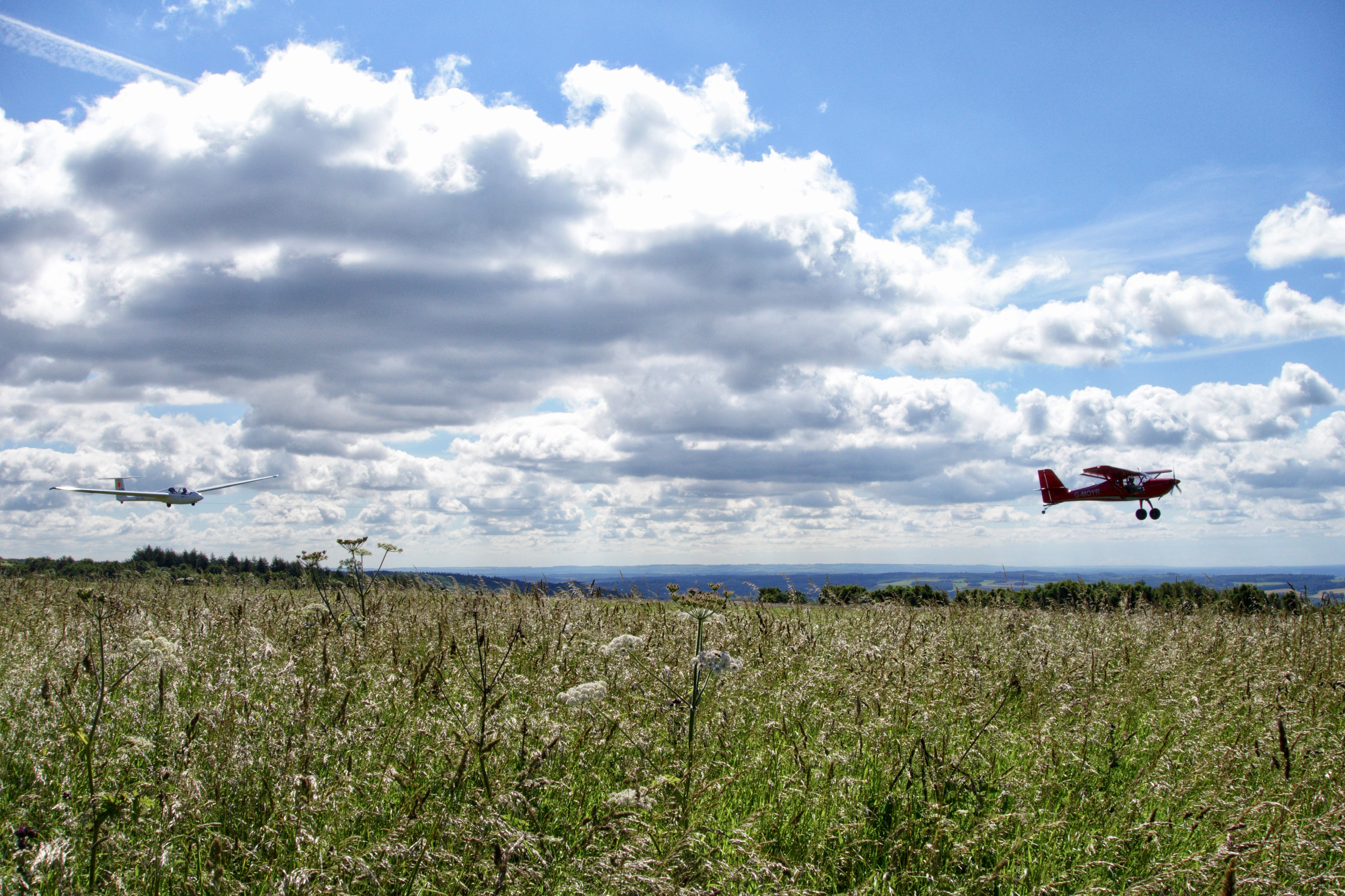
Glider launch from Roulston Scar
It was quite a spectacular sight, watching the little red plane towing the glider over the edge of the cliff and up into the wide blue yonder. The conditions must have been ideal because, as the morning progressed, the tow plane worked tirelessly, towing glider after glider, until there were several of them up there, riding the thermals, soaring and circling like a wheel of patient vultures.

Gaining height
We lingered for a while, watching a glider being towed ever higher, until the moment when it reached the optimum height and the tow rope was released. The view from up there must have been incredible, although even from our lowly vantage point it was still pretty special. And, truth to tell, I’d sooner be viewing it with my feet planted firmly on solid ground. Looking out to the western horizon I could just identify the outline of some of the higher fells of the Yorkshire Dales, including the table-top shape of Penhill in Wensleydale. I’ve always felt drawn to the west of the country, where the ground is significantly higher than in the east. And this was the perfect vantage point from which to gaze longingly in that direction, contemplating times past spent amongst those distant hills and, hopefully, future adventures awaiting us.

Spectacular views from above and below
After a short walk along the ridge we arrived back by the side of the A170 at the point where the traffic slows for the bend which marks the start of the descent or the end of the climb, depending on the direction of travel. A dash across the road brought us to the Sutton Bank National Park Centre which had just opened its doors for the day, enabling us to pay a quick visit to the facilities and stock up with some flapjack. As it was still early there were relatively few visitors milling about but I knew that later in the day the area would be much busier. The café, information centre, nature hub and cycle hire are all big attractions, not to mention the many cycle trails and paths which radiate out from the centre, some of which are wheelchair accessible, including the short path to “England’s Finest View”. It was in this direction we were now heading, to meet up with the Cleveland Way once again.

Sutton Bank National Park Centre (this photo was taken on a visit the previous autumn)
A few hundred yards further along and we were back on track, striding out along the path in a northerly direction. To begin with we encountered one or two walkers along the way, exchanging cheery “good mornings” as we passed, but their numbers dwindled as our distance from the visitor centre increased and soon we were alone again. Once or twice we wandered closer to the edge of the cliff, to enjoy the sweeping view and to look down at the waters of Gormire Lake below, just visible through gaps in the trees.
Formed by glacial erosion over 20,000 years ago, Gormire has no visible inflow or outflow. The fourth largest natural lake in Yorkshire, it’s fed by an underground spring and drained by underground limestone channels. Legend has it that the lake is bottomless and there are several myths associated with its eerie depths. The most well-known of these is the tale of a knight who foolishly challenged the abbot of nearby Rievaulx Abbey to a horse race. As they approached the edge of the cliff the abbot transformed into the devil and pursued the terrified knight over the edge and down into the watery depths below, which obligingly opened to reveal the entrance to hell.
As I studied the peaceful looking waters, the lake didn’t look particularly menacing and neither did it seem to deserve its name, which roughly translates as “filthy swamp”.

Looking down on Gormire Lake
Just a short distance along and a few more steps closer to the edge afforded us with a view of Whitestone Cliff, or White Mare Cliff to use its alternative name, possibly in a nod to the legend of the afore-mentioned demonic horse race. A popular place for rock climbing, the cliff gives its name to the nearby village of Sutton-under-Whitestonecliffe, which, with 29 characters, is supposedly the record-holder for the longest hyphenated place name in England. Beneath the cliff, Gormire Lake nestled snugly in the midst of Garbutt Wood, while beyond a tree-covered Hood Hill rose prominently in the landscape. A glorious scene in the hazy July sunshine.

Whitestone Cliff
We’d taken our time and practically dawdled along the ridgeway, drinking in the view and stopping to figure out faraway landmarks in the distant haze. When we reached what appeared to be something of a turning point I glanced at my watch and was shocked to discover the time. It had taken us over two hours to walk just three and a half miles. Clearly it was time to step up the pace a little. A small, redundant gate carrying a signpost pointed us in the direction of Sneck Yate, a landmark on the old Hambleton Drove Road, a track we were to follow a little later in the day.

Signpost to Sneck Yate
The elevation seemed to be decreasing slightly as we headed towards Boltby Scar, although the views continued to be stunning. I tried not to stop too often but on such a lovely day with such a delightful prospect to admire, it was hard to resist pausing to compose the occasional photo. And besides, my rucksack was really chafing. The humidity had caused a build-up of moisture between the straps and my shoulders and somehow this discomfort seemed to increase the sense of weight, in turn causing a deep, muscular ache. A solution was found by using a microfibre towel as a kind of makeshift shoulder pad. The relief was instant and soon I was striding out again, feeling much better.

The walking was easy going on the even grassy slopes above Boltby Scar and, rucksack irritations aside, we soon arrived at Sneck Yate, a popular landmark for cyclists tackling the hill climb of Sneck Yate Bank. Although some sources attribute the name Sneck Yate to a sneck (latch) on a yate (gate), it is more than likely Viking in origin “Snakr’s Gate”, taking its name from the first Viking settler in the area, with gate, in this context, meaning road.

Pleasant walking above Boltby on the way to Sneck Yate
Our path now crossed Snakr’s road and entered a small wooded area, providing some much appreciated shade from the sun. Around three-quarters of a mile later we emerged out of the plantation and arrived at the welcome sight of High Paradise Farm, a tea room I’d read about with eager anticipation while planning our walk. And it wasn’t to disappoint. We had arrived, it seemed, at the perfect time for lunch.

High Paradise Tea Room
We hadn’t passed many people since leaving the Sutton Bank visitor centre and so it was something of a surprise to discover that the place was rather crowded. And no wonder! The food was great and the surroundings delightful. Sitting at a picnic table in the pretty little courtyard, I enjoyed a delicious chicken and pesto sandwich, followed by a satisfying wedge of cake, washed down with a bottle of Helmsley Honey Ale. Given the quality of the food it wasn’t surprising that so many people had travelled here for their lunch. What was surprising though was that the only way to get to High Paradise is on foot, by cycle or on horseback. Paradise indeed!

Tasty Helmsley Honey Ale
Leaving High Paradise feeling rested and satisfyingly full, we rejoined the Cleveland Way as it took an immediate left turn to join up with the old Hambleton Drove Road. Clouds had gathered while we’d been enjoying our lunch, but the day remained warm and humid.
The Hambleton Drove Road was part of an ancient highway running from Scotland to the south of England, along which drovers herded thousands of cattle to market. During the 18th and 19th centuries improved roads were introduced on the lower ground and a toll was imposed to travel along them. The drovers didn’t want to pay any tolls, so they continued to drive their cattle along the higher ground, giving this ancient track the name by which it is known today. Before the introduction of rail and modern road transport, tens of thousands of cattle were driven along this route. Local communities along the road welcomed the drovers as they brought with them news from the outside world, and would often deliver mail and other small items. Progress was slow along the drove roads, typically 9 to 12 miles a day, and a series of inns along the way provided rest and sustenance for the drovers and pasture for their cattle. Sadly, as a beer is always a welcome addition to any of our walks, none of these inns survive today but we were to pass the site of one later in the day.
Droving had all but died out by the early 20th century and most of the old drove roads have been incorporated into today’s modern road network. However, here on the Cleveland Way, there still remains a six mile long stretch, part of which we were now happily striding along.

Along the Hambleton Drove Road
We were to follow the old drove road for the next five miles, to just above the village of Osmotherley, which was to be our base for the night. The going underfoot was easy and the ascent gradual as we headed in the direction of the highest point on this section of the walk, the ominously named Black Hambleton. To our left ran an impressive long section of drystone walling and on the ridge of the adjoining Kepwick Moor we could make out the shape of several Bronze Age burial mounds, rising like pimples on the landscape. Ahead of us we could see an off-road vehicle parked alongside the track and as we grew closer a pair of drystone wallers came into view, busily rebuilding a section of wall. One of them called out a greeting as we approached and we went over for a chat and to admire their craftsmanship.
“Nice day for it’, I said, rather lamely.
“Aye, it’s grand up here whatever the weather”, the waller responded cheerfully. “You’ll be on the Cleveland Way no doubt, looking at the size of them bags.”
We stayed and chatted to them for a while, making a fuss of their friendly border collie and watching the skilful way the right sized stones were selected and positioned, before making our farewells and continuing along the drove road.
“Enjoy the rest of your walk”, one of them called out after us and I waved back in acknowledgement. Watching them at work had been a relaxing and satisfying thing to do and I could have happily removed my rucksack and rested for a while, but time was moving on and there were still a few miles remaining between us and Osmotherley.
As we grew nearer to the high point of the day, by the side of Black Hambleton, my attention was drawn to what looked like a small gravestone by the side of the road. This, it turns out, was a memorial to the site of the Limekiln House Inn, one of the old inns frequented by the drovers. What a wild and remote spot for there to have been an inn. And what a welcome sight it would have been, I thought, as my mind turned to the prospect of a sit down and a beer. It’s not that I’m obsessed with beer, but the thought of it alone can be incredibly sustaining on a long walk, especially when your rucksack is beginning to feel like you’re giving a piggy-back ride to a Sumo wrestler.
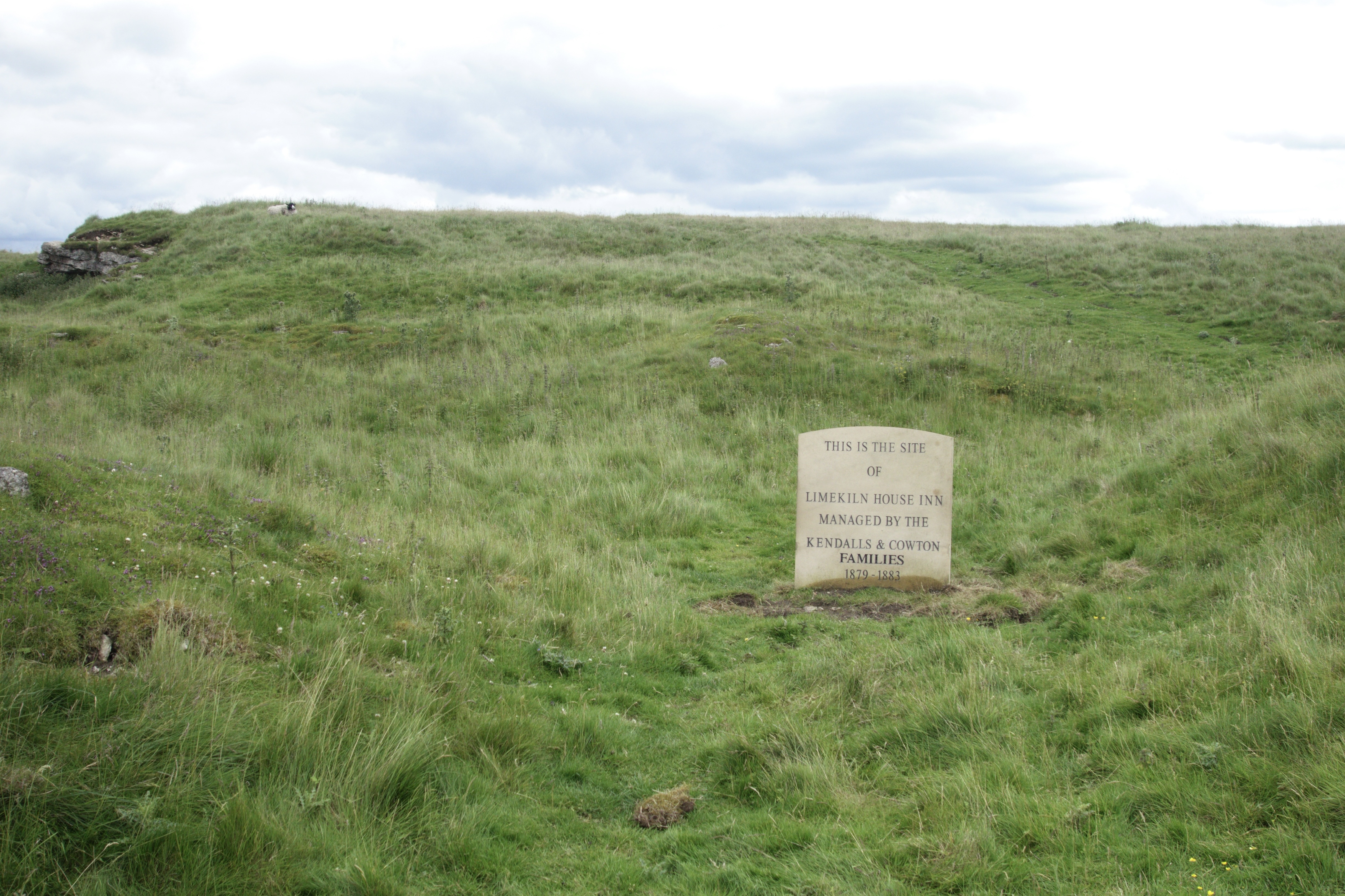
Site of the Limekiln House Inn
The track narrowed as it began its descent along the side of Black Hambleton and, as it wound its way around the hillside, the landscape ahead of us changed, allowing us our first glimpses of Osmotherley nestling in the valley below. The descent steepened slightly as we approached the road below at a junction and popular parking place for walkers known as Square Corner.

Approaching Square Corner
Downwards the path wound along from Square Corner as we entered Oakdale, following a nicely paved path through the bracken to pass by a former reservoir in the valley bottom. Now reduced to a small pond, the reservoir once supplied drinking water to the region but was decommissioned in 2015, having been previously downsized in the 1990s. The valley of Oakdale itself was very pretty and a perfect haven for wildlife.

Above Oakdale
A short walk across farmland finally brought us to our destination for the night. The pretty little village of Osmotherley carries the distinction of being ideally positioned on two long distance trails – the Cleveland Way and the Coast to Coast. As a result of this, our inn for the night was busy not only with locals but also several enthusiastic Coast to Coasters.
We received a warm welcome at the Golden Lion and, after downing a most welcome pint of beer, we were shown to our fabulous room. I can quite safely say that this was one of the nicest rooms we’d stayed in on any long distance walk. It was spotlessly clean and modern, with a king sized bed and amazing shower. Our room even had its own patio area complete with garden furniture. And, most importantly given our experience the previous night, it smelt nice and fresh.

Our room’s very own garden
Our evening meal in the candlelit dining area was of an equally superb standard and we returned to our room relaxed and happy, safe in the knowledge that the phantom pong of Kilburn wasn’t awaiting us.
From recent reviews I can see that since our stay the Golden Lion has had a change of ownership, but it appears to continue to receive mostly favourable reviews, so I’d definitely welcome a return visit.

Map of day two’s route
Up next…..On our third day on the Cleveland Way we leave Osmotherley and walk along the roller-coaster northern escarpment of the North York Moors ending the day with a revisit to a favourite watering hole.


Comments
Post a Comment